
-
 8992 Hits
-
 79.78% Score
-
 11 Votes
|
|
Mountain/Rock |
|---|---|
|
|
32.77659°N / 17.07996°W |
|
|
Hiking |
|
|
Spring, Summer, Fall, Winter |
|
|
5381 ft / 1640 m |
|
|
Overview
 Pico Ruivo do Paul seen from the south-east Pico Ruivo do Paul seen from the south-east |
Madeira is a deeply divided island. Unlike Cyprus, however, the division is not political but rather geografic: while to the east of Boca da Encumeada you will find one of the wildes volcanic mountain ranges on earth with summits up to nearly 2000m, to the west of the pass there is the huge, slightly sloped high plateau Paul da Serra. The plateau is one huge, windswept bog thanks to Madeira's generous precipitation.
To the north and east Paul da Serra shares some of the wildness of Madeira's central range with huge and deep near vertical faces, to the south and west, however, it more gradually lowers to the coast. Out of this plateu, two summits rise some 3km apart from each other: Pico Ruivo do Paul, at 1640m, Paul da Serra's highpoint and Pico Bica da Cana, at 1620m only a little lower than its neighbour. Both rise above the north and east faces so that they become massive undertakings from one of the lower trailheads while reachable by a short stroll from their respective parking lots on the high plateau.
 |  |  |
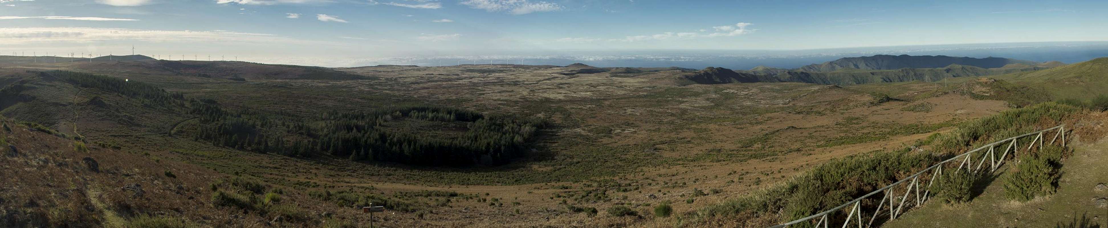
Pico Ruivo do Paul stands above the north face of Paul da Serra. It offers big views down towards the coast 1600m beneath. In particular the valley of Sao Vicente attracts the views. To the east, Madeira's central range rises above the valley pith Picos Ruivo, Casado, das Torres, Arierio and Grande making up a wonderful, rugged panorama. to the south, the swamps and bbos of Paul da Serra look like an endless sea of bushes and grassland.
 |  |  |
A particularly fine route to Pico Ruivo do Paul runs along and through Paul da Serra's west faces (see route section below). It follows one of the irrigation channels which provide the south side of the island with water, Levada do Lombo do Mouro. Running along about 200m beneath the plateau it offers great views towards the central range. However, be prepared to be showered by an endless series of cascades which batter and are collected by the levada.
Paul da Serra
  |
Getting There
 Madeira's Central Range seen from Levada do Lombo do Mouro
Madeira can be reached from any of the major European airports. There are almost no regular flights (with the exception of some portugese airports) but quite a lot of charter flights.
The closest trailhead to Pico Ruivo do Paul is only a few hundred metres to its south on the plateau Paul da Serra. Other options are Boca da Encumeada, a parking lot near Pico Bica da Cana, Paul da Serra's second highest summit or the town Sao Vicente on Madeira's north coast. All trailheads are close to each other and can be reached very similarily.
- Take Motorway R101 until its end at Ribeira Brava.
- After the long last tunnel don't turn to Ribeira Brava but to Serra de Água (ER104).
- For Sao Vicente stay on the road and drive through the Encumeada Tunnel.
- For the other trailheads go left at the start of Serra de Água turn left and go up to Boca da Encumeada on ER105.
- For the Paul da Serra trailheads pass the lookout in the pass and drive up ER105 through multiple tunnels. After about 1km there is a small parking lot on the left hand side. Here you can start on a route leading through the Paul da Serra west face on Levada do Lombo do Mouro.
- If you stay on ER105 until you reach the plateau you'll find the first parking lot near Pico Bica da Cana on the right hand side.
- After two turns in the road you'll reach the Estanquinhos recreation area directly underneath the Pico Ruivo do Paul summit.
Routes
 The Central Range seen Pico Ruivo do Paul
- Sao Vicente Route (best for mountain biking)
From Sao Vicente there are a number of dirt roads which lead up to Paul da Serra through the Ribeira do Passo Valley. At around 300m elevation they pass to the south-west towards the valley of Ribeira dos Ariöes, where they join a road which heads up to Paul da Serra in endless switchbacks. Once you reach the plateau you are near the Estanquinhos recration area and only a few steps away from Pico Ruivo do Paul (see below).
- Encumeada Route
Directly beneath the saddle (southern side) you'll come across the irrigation channel of Levada do Norte. Follow it to the right until you reach a lavada intersection after some 500m. Straight on Levada dos Rabacas leads to one of the longest levada tunnels to the south of Paul da Serra. Instead turn right, staying on Levada do Norte which immediately runs through a long tunnel as well. After the tunnel the levada turns left and runs through an old forest through the Folhadal Valley. The second, even longer tunnel follows, after which a short path sidesteps to Cascata de Folhadal. Back at the levada, follow it until it reaches the third tunnel. While it is possible to stay near the levada the tunnel is extremely long and probably no fun to hike. However, jjust at the entry into the tunnel a staircase leads downwards to a narrow path which heads in north-westerly direction. Where it ends another staircase, this one seemingly endless, leads up to Paul da Serra. As you reach Ribeira dos Agriöes the path bends northwards and leads to the dirt road coming up from Sao Vicente. Follow the road to the Estanquinhos recreation area.
- Levada do Lombo do Mouro Route route (1km above Encumeada)
![Waterfalls abound]() Waterfall filling the levada
Waterfall filling the levada
Opposite the parking lot, 200m down the road, a path starts which runs in . parallel to the road at first. After some 500m you'll reach a staircase which heads up to a path which climbs to Levada do Lombo do Mouro. It reaches the levada near the Pinaculo Tower. It follows the levada for a bit running beneath a multitude of waterfalls until you reach Pico Bica da Cana. You can head up to the mountain (see next route from there) or stay on the levada path. After you have passed the levada sources the path turns into a mountain path, running along the topmost west face of Paul da Serra. It reaches the dirt road from Sao Vicente near its end close to the Estanquinhos recreattion area.
- Pico Bica da Cana Route
Starting at the parking lot west of Pico Bica da Cana you'll want to climb the mountain first. After returning hike to the bend on ER105, where the road turns from north to nort-west. Here a maintenance road for the windmills turns off northward. Follow the road or a path to the other side of the windmmills which both lead to the Estanquinhos recreation area.
- Estanquinhos loop
A very short outing: from the parking lot head back to ER105. At the road the young Levada do Paul crosses. Follow it to the north until you reach its source, a lake in Ribeira do Lajjeado. Pass the lake, where a path starts which takes you to Pico Ruivo do Paul. Descend the south-east slope of the mountain, which leads directly back to Estanquinhos.

Red Tape
There's no red tape here. However, sometimes the parking space at Estanquinhos is closed with bars across the roads. Also, , take extreme care with fire. There has been a series of forest fires in the last years which destroyed much of Madeira's wonderful vegetaion, especially on the south side of the weather divide.Accommodation
You can find a lot of hotel rooms and apartments on Madeira. Either visit the next travel office or do an internet search. The island is small, all trailheads can be reached by car in an hour from almost anywhere on the island. Most accomodation can be found in the south of the island near Funchal and Camara de Lobos.Weather Conditions
Weather conditions cannot be predicted accurately. Madeira is located in the trade wind zone. You almost always encounter northeastern winds which carry a lot of humid air. Being forced to climb to higher altitudes this moisture condenses into clouds. This in return means that most of the time the northern part of the island is covered in clouds from altitudes of 1000m through 2000m.
The mountains themselves - being of the same altitude -finally stop the clouds so that on their southeastern slopes the clouds "run out". Look at the pictures - it looks like the clouds creeping over the weather divide. Boca da Encumeada - being some 500m lower than the surrounding summits - is a gateway for the clouds from north to south. Thus it very often is covered in mist. Unfortunately all of the major peaks of Madeira lie around the weather divide, sometimes within, sometimes just out of the clouds.
The following table shows weather data for Funchal on the southern coast. Be careful with these data if you want to climb the summits...
| Month | Jan | Feb | Mar | Apr | May | Jun | Jul | Aug | Sep | Oct | Nov | Dec |
| Avg. day temp.[°C / °F] | 16 / 61 | 16 / 61 | 17 / 63 | 20 / 68 | 24 / 75 | 27 / 81 | 29 / 84 | 29 / 84 | 27 / 81 | 23 / 73 | 21 / 70 | 17 / 63 |
| Avg. night temp.[°C / °F] | 9 / 48 | 9 / 48 | 10 / 50 | 12 / 54 | 15 / 59 | 19 / 66 | 21 / 70 | 22 / 72 | 19 / 66 | 16 / 61 | 13 / 55 | 11 / 52 |
| Water temp.[°C / °F] | 16 / 61 | 15 / 59 | 16 / 61 | 16 / 61 | 19 / 66 | 22 / 72 | 24 / 75 | 25 / 77 | 24 / 75 | 23 / 73 | 20 / 68 | 17 / 63 |
| Rainy days | 12 | 7 | 8 | 4 | 2 | 1 | 0 | 0 | 2 | 6 | 6 | 10 |
Maps & Books
Maps
- Madeira
Tour & Trail Map
Discovery Walking Guides
1:40000
ISBN: 190494678X
Books
My recommendation is a guidebook by Rother Verlag, available in several languages. The book is an excellent hiking guide covering all the interesting areas of the island. Since it comes with small maps for each excursion it might even be used without a map to support them.
- Madeira
Rolf Götz
Rother Verlag
ISBN 978-3-7633-4811-4 (English)
ISBN 978-3-7633-4274-7 (German)
ISBN 978-3-7633-4910-4 (French)
ISBN 978-3-7633-4297-6 (Portugese)
ISBN 978-3-7633-4708-7 (Spanish)