
|
|
Mountain/Rock |
|---|---|
|
|
32.69780°N / 116.16449°W |
|
|
Scrambling |
|
|
Spring, Fall, Winter |
|
|
4512 ft / 1375 m |
|
|
Overview
Jacumba Mountain is the southernmost summit on the Sierra Club Desert Peak Section List in California. Located a few miles north of the Mexican border, Jacumba sees comparatively little traffic compared to other summits in the Anza-Borrego Desert State Park area. A series of decent dirt roads leads to the base from Highway S2 and Mortero Palms, a popular stop for 4WD enthusiasts. But those willing to break off the beaten path, Jacumba is a relatively straightforward cross country adventure with fantastic views across Southern California and Northern Mexico.
The original page for Jacumba was deleted from SP, so I thought it would be worthwhile to make a new one.
The original page for Jacumba was deleted from SP, so I thought it would be worthwhile to make a new one.
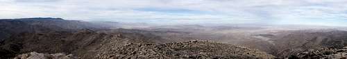
Jacumba Summit Panorama.
Getting There
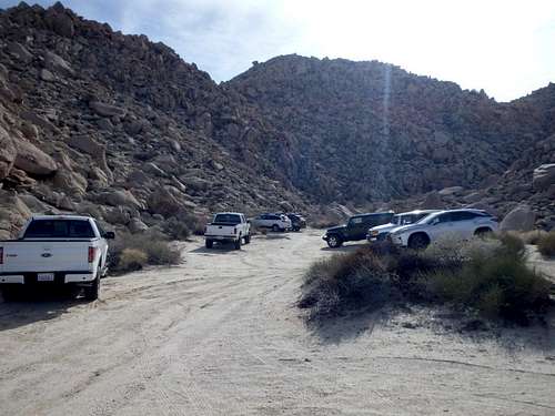
Mortero Palms Trailhead
The best place to start a climb of Jacumba is from the Mortero Palms trailhead. To get there, head west on Mortero Canyon Road, a sandy dirt road that is in pretty good shape aside from one short section which definitely requires high clearance. The turn off for Mortero Canyon Road is 8.5 miles north from the I-8 Ocotillo exit on Highway S2, or 39 miles south of Scissors Crossing. Follow this sandy track 4 miles to Dos Cabezas, an old railroad station with only a water tower and tracks remaining. Crossing the track at Dos Cabezas requires high clearance and is not recommended. For an easier option, follow the dirt road paralleling the track 1.5 miles south and turn right to cross the track. Once on the west side of the track, turn right heading north (back towards Dos Cabezas) and hook left onto Mortero Canyon Rd in about 50 yards. You'll hit a fork in about a mile, I recommend keeping left, although the road rejoins in 0.3 miles. Beyond this is a final fork in 0.5 miles, with the left going to Dos Cabezas Spring, and the right going to the Mortero Canyon Trailhead. Keep right and follow the road to its end at the small parking area.
Do no attempt this route without high clearance, there is a short section before Dos Cabezas that requires it, although the road overall is quite sandy and smooth.
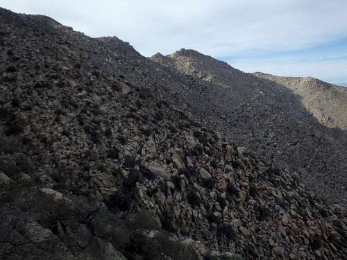
From the Mortero Canyon Trailhead, there are two main options. The first, and probably easiest, is to cross the wash north and turn into Mortero Canyon (the canyon directly across from the trailhead IS NOT Mortero). You can follow this canyon to about 3400' then scramble up the north-south ridgeline of Jacumba, hiking the remaining distance south to the summit. This route goes slightly out of the way with the canyon angled slightly north and away from Jacumba, but utilizes a good use trail for those hiking to Goat Canyon Railroad Trestle (not visible from the summit). You have to leave this trail and head cross country up the ridgeline at some point, and be sure not to follow it all the way to Goat Canyon.
The second option, which is more direct but steeper, follows the canyon south of the main Mortero Canyon, with mixed class 2 scrambling around boulders. About 0.5 miles in is a fork, either of which will work and put you at the base of the summit. From there it's pure cross country using either the broad gully just north of the summit or any number of steep ridgelines to the top. Those comfortable with desert cross country should have no trouble with the route, although the higher slopes have some scrappy junipers that seemed to get in the way.
Red Tape
No park entrance fees or red tape that I know of. There is a border patrol stop on highway S-2 near the turnoff but I've never seen it manned.
This hike would really only be enjoyable November-March, with late spring through early fall being dangerously hot. No reliable water en route.
Camping
Camping is abundant in Anza-Borrego Desert State Park, with both developed campground options and at large camping off the dirt roads in the park.
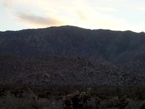
Jacumba at sunset.
External Links
My Trip Report-
The Mountains Are Calling: Jacumba Mountain