-
 5520 Hits
-
 85.87% Score
-
 21 Votes
|
|
Mountain/Rock |
|---|---|
|
|
46.25556°N / 13.68902°E |
|
|
Hiking, Scrambling, Skiing |
|
|
Spring, Summer, Fall |
|
|
6604 ft / 2013 m |
|
|
In Slovenian language č, š and ž are pronounced like ch, sh, and zh. Our mountain is written: Škofič.
Overview
The south-eastern part of Krn group was already described quite in detail on the page of Rdeči rob. There, the steep southern wall of Rdeči rob was described, the inclined plateau north of it and nice meadows above Tolminka valley. Still, the description of the area is not complete, until its highest summit is not described. And that is Škofič, otherwise a summit which is less important in a mountaineering sense.
The marked paths of Krn group go close to the summit of Škofič, but not on it. The path from the south, from Leskovica meadow and Sleme meadow is quite frequented. But what attracts hikers is more the vicinity of a small lake, called Jezero v Lužnici, and many of them of course only are passing further towards the central part of Krn group. As described on Rdeči rob page, the ascents from the east are quite long and lonesome. Škofič is also primarilly a hiker's goal. The tour is not hard, but it requires some experience in a remote terrain. Especially nice is the tour in early summer, when the eastern slopes are full of blossoming flowers. In winter, the ascent is harder. Other places of interest in the broader area are fully described on the page of Rdeči rob.
Geographical Overview
From Krn, the central ridge of the group goes towards the east, where the other highest summits of the group rise: Batognica and Vrh nad Peski. From the latter, the ridge towards the east broadens and lowers towards Bohinj group more as the edge of a high plateau. But towards the south-east a side ridge goes towards Rdeči rob. Till Mali peski the ridge is easy, so also the main path towards Bohinj group follows it. East of Mali peski there's a high edge, where a monument from the World War I stands. There the marked path turns towards the north-east, while another path, a non-marked ex mulatiera keeps descending towards the south-east, towards Lašca alpine meadow.
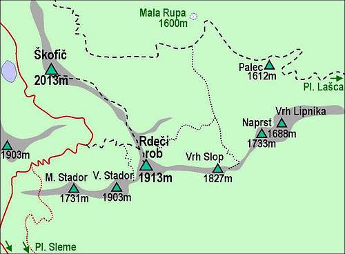
The ridge of Škofič continues towards the south of Mali peski. This ridge is sharp and so crumbly that climbing over it would be almost impossible. It has to be detoured, either by the western or eastern side. The ridge from Škofič summit further towards the south-east is easier. Only on the upper part some care is needed, the rest all the way to Rdeči rob is easy. Also a decent path follows this ridge. This is the normal ascent on Škofič. The western face of Škofič is rocky, falling steeply in the valley, where Jezero (lake) v Lužnici lies. The eastern face is less steep, but crumbly and unpleasant. With some carefulness it still allows the ascent, if one would be coming from the north, not wanting to go fully around.
Getting There
See the main Krn Group page and Julian Alps page to get an impressiopn how to reach the towns of Tolmin and Kobarid!
1. The western, shorter approach on Škofič starts in Krn village, 865 m. This picturesque mountain village can be reached by a mountain road, starting either in Kobarid or in Kamno, on the shore of Soca river.
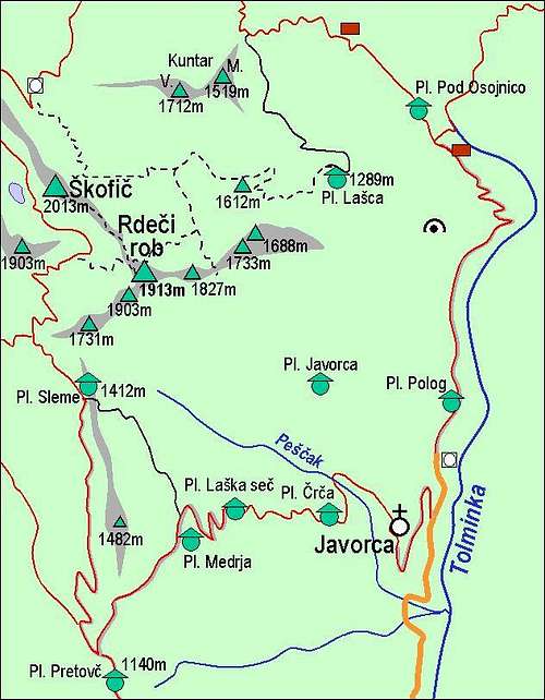
2. The eastern approach starts in Tolminka river valley. From Tolmin town we can drive by a narrow mountain road some 6 kilometers into the valley till Polog meadow, below Javorca.
3. You might see on maps mountain roads up on meadows Pretovč and even Sleme. I'm not sure what is their formal status, but walking by them I can say that they are bad, steep and narrow, appropriate perhaps only for 4WD, with a praying not to meet another vehicle, coming in the opposite direstion.
Routes Overview
As they are identical, more in detail the three usual ascents are described on the page of Rdeči rob.
1. From Krn village, 865 m, over Leskovca meadow, 1230 m into the valley between Mali Stador (on the right) and Leskovški vrh or Maselnik (on the left). From there towards the east on the main ridge near Rdeči rob and towards the north-west on top. 3 hours, medium hard, partly not marked, steep hike-up.
2. From Tolminka valley over planina Sleme. You start below Javorca, on some 500 meters of altitude. By marked paths on Sleme meadow and further around Stador. East of Mali Stador you reach the crossroads with the path from Leskovca meadow and from there you continue on top, as described under #1. 4 h 30 min.
3. From Tolminka valley over Lašca meadow. This is the most beautiful, but not the shortest and the easiest approach. As it is not marked, I described it on a separate page, here is only the outline: Polog, 458 m, planina pod Osojnico, 700 m, planina Lašca, 1289 m, around Palec, Mala rupa, 1600 m, southeastern ridge, summit. 5 hours. Below a shepherds path, above Lašca abandoned military paths, hard to follow, below the summit ridge a steep, pathless slope. This ascent, together with the descent by route #2 makes a wonderful one-day round tour.
If you are crossing the whole Krn group, you migh be coming also from other directions, for example from the summit of Krn (hut) over Batognica, or from Krn lake.
Red Tape
No limitations. The area lies within the broader borders of Triglav National Parc.
Huts and Camping
- There is a hut on Kuhinja alpine meadow, but it is only 30 minutes away from Krn village, which can be reached by car.
- The other mountain hut is on the summit of Krn, which is also not really supporting the ascent on Škofič.
So you do a one-day hike or rely on shepherds hospitality or take a sleeping bag and a tent and sleep in a 'thousand stars hotel'.
When to Climb?
The best months are early summer, when snow is gone and autumn. Summer can be very hot, especially on the east approach. In winter and spring most of the west ascent can be done with skis. It is possible to ski from just below the summit ridge down to Krn village. The passage on the summit ridge and on top is very steep, so in snow winter equipment (ice pick, crampons) is needed.


