
-
 24721 Hits
-
 82.48% Score
-
 15 Votes
|
|
Mountain/Rock |
|---|---|
|
|
49.41470°N / 124.9197°W |
|
|
Hiking, Mountaineering, Skiing |
|
|
Spring, Summer, Fall, Winter |
|
|
5108 ft / 1557 m |
|
|
Introduction
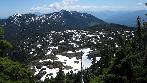
Mt Joan W Aspect
The Beauforts have been heavily scarred by logging and access is often at issue. However, they remain a very popular destination for day trips in all seasons. Being the highest point, Mt Joan is, naturally, one of the most popular destinations in the area. Don’t be put off by this however. This is Vancouver Island after all. The chances of meeting anyone else on any Island trip are pretty remote.
Together with its neighbours, The Squarehead and Mt Curran, Mt Joan forms a cirque around the head of Roaring Creek. If time permits, a traverse of all three summits around the cirque is a superb trip.
Like most of the mountains in the Beaufort Range, Mt Joan is named for a local personality from years gone by. Joan Moorehead was a prominent citizen of the nearby community of Port Alberni. Five kilometres to the south of Mt Joan is Mt Hal, named after Hal Moorehead, Joan's brother.
Mt Joan N Aspect
Getting There
Vancouver Island can be reached by air from Toronto, Vancouver, Seattle, Calgary and Edmonton to Victoria, Nanaimo, Comox or Campbell River and by ferry from Port Angeles to Victoria on The Coho Ferry and on BC Ferries from Vancouver to Victoria or Nanaimo. Public transport on the Island is notoriously poor and anyone arriving by air would be advised to rent a car.There is some gravel road involved in getting to the Joan/Squarehead/Curran access spur but, generally, a normal 2WD sedan is fine. Progress up the access spur is for high clearance 4WD vehicles only.

Access spur road
Most visitors will approach the area from the Inland Island Highway 19. From the north or south turn west on Cook Creek Road. This is the second traffic light after the Island Highway becomes freeway travelling north from Parksville or the first if coming south from Courtenay. The turn is also signed for Rosewall Creek Provincial Park. Set your odometer to 0 as you leave the highway.
The pavement ends after 200 metres as the road turns left. Keep right at a prominent junction after 2-3 km. This is a forest service road and is well signed with yellow kilometre markers. Just after marker 14 cross Rosewall Creek – there is a small camping area by the creek below you - over a second creek and finally, 15.6 km from Highway 19 reach the logging spur that gives access to Mt Joan. There is a prominent yellow sign nailed to a tree announcing that access to Mts Joan and Curran lies this way. If you cross a third bridge – over Roaring Creek – you’ve gone too far.
Drive 200 metres up the spur to a nice flat parking/camping area right by Roaring Creek. Elevation at this point is about 350 metres.
Approach
The method of progress beyond the parking area varies. Following recent (2013) logging, the road is clear of deadfall it can be driven to an elevation of ~750 metres with a high clearance 4WD vehicle. The old "tank trap” ditch that defeated many an unwary driver is long gone but there are still many water bars to cross. The route, however, is straightforward. Don't take the first left uphill turn. Keep right/straight here and follow the road around to where it heads uphill on its original pre-logging course. The driveable section of the road ends at a semi-flat area with a turn round spot and another yellow sign for Mts Joan and Curran. Park here.
From the parking spot walk up the remains of the road – one area has sloughed off preventing driving – to another yellow trail sign at a junction for Mt Joan to the left and Mt Curran to the right. Altitude here is about 850 metres.
If the spur is impassable or you don’t have a 4WD vehicle, it takes about an hour to walk up to this point from the lower parking area off Cook Creek FSR.
As of May 2016, access off Cook Creek Road is closed. Leave sufficient time and energy therefore for the walk up to what was the upper parking area. I will try to keep any developments on this issue as current as possible.
Route
From the Joan/Curran junction go left, down and across Roaring Creek. The crossing may be tricky when there is snow on the ground. There used to be a bridge here as evinced by the abundance of old cable lying about. Almost immediately make a second, easier creek crossing and find yourself on the faint remains of yet another old road. This one is long since abandoned and is little more than a trail. Follow the remains of the road as it switchbacks up the hillside to an elevation of ~1,000 metres. Shortly before it ends at N 49° 25.329 W 124° 54.220 pick up flagging and a boot-path leading off the road and heading SW. This point may be tricky to locate when there is snow on the ground. In which case find a steep snow gully at N 49° 25.300 W 124° 54.199 and follow it up to the SW.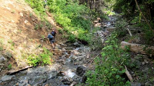 First Creek Crossing |  Second Creek Crossing | 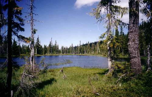 Sub Alpine Tarn below Mt Joan | 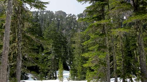 Joan/Squarehead Col |
From the tarns flagging follows a creek up into a high meadow (abundant flowers in spring) and into the col between Mt Joan and The Squarehead. Turn left at the col and follow Mt Joan’s gentle north ridge to the top in 20-30 minutes.
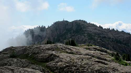
The summit is unfortunately crowned by one of those horrible Vancouver Island microwave phalluses. Ignore it and have your photo taken by the trig point with its old wooden Comox and District Mountaineering Club (CDMC) sign instead. There is also a summit register to sign.
There are lovely views in all directions. Port Alberni, the Alberni Inlet and Mt Arrowsmith dominate to the south. To the east are Denman and Hornby Islands and the Strait of Georgia. The most spectacular views are to the north. Joan’s near neighbours, The Squarehead and Mt Curran and beyond the whole of the south aspect of the mountains of Strathcona Provincial Park, with Nine Peaks, The Septimus massif, Mt Albert Edward and the Comox Glacier particularly prominent.

Mt Joan Summit View S
Red Tape
None.As always, make sure that you have left a detailed trip plan with someone responsible. The RCMP and the appropriate SAR agency will respond in an emergency but it is up to you to have the mechanism in place that will initiate the call-out process if it becomes necessary.
Camping
Mt Joan is generally considered a day trip but if you wish to camp en route, there are no restrictions other than the availability of water and a flat spot for your tent. Fires are, however, strictly prohibited, so you must pack a stove. Giardia is well documented throughout Vancouver Island, so boil or treat all water.The parking area just off Cook Creek Road makes a good spot to car camp if you want an early start on a day trip up Joan. Although the upper parking area has no obvious flat spots, with a little creativity it's possible to position your vehicle such that you can sleep inside. I have done this and it does make a great place to get an early start from. There's certainly no water though, so haul a barrel in with you.
Useful links
Another good source for route information is Island Alpine – A Guide to The Mountains of Strathcona Park and Vancouver Island, Philip Stone, Wild Isle Publications, 2003, ISBN 0-9680766-5-3For precise road directions get hold of a copy of Vancouver Island Backroad Mapbook: v7
Weather and other considerations
Port Alberni weather will likely reflect the most accurate forecast for Mt Joan.For winter trips consult Vancouver Island avalanche bulliten prior to leaving home.

