
-
 13180 Hits
-
 83.69% Score
-
 17 Votes
|
|
Mountain/Rock |
|---|---|
|
|
50.29670°N / 125.7025°W |
|
|
Hiking |
|
|
4757 ft / 1450 m |
|
|
Overview
Mt Kitchener is the second highest summit in the Prince of Wales Range which is found on the northeast coast of Vancouver Island, British Columbia.Kitchener’s serrated 4-peak summit ridge is an impressive sight from the Highway 19, the main (and only) paved thoroughfare on the Island north of the town of Campbell River.
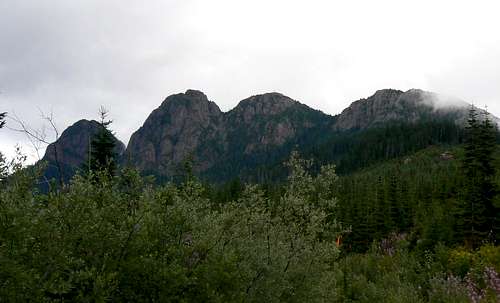 Mt Kitchener southwest aspect Mt Kitchener southwest aspect |
Excellent high access from old industrial roads as well as a maintained trail to the first of the four summits makes Kitchener an often visited and popular objective for north Island residents.
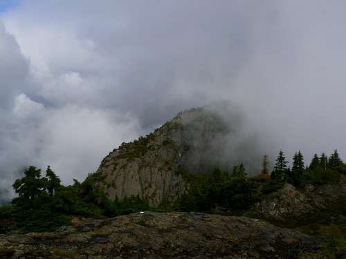
Mt Kitchener third summit south aspect
Mt Kitchener is named for Horatio Herbert, Field Marshal The Right Honourable The Earl Kitchener, celebrated military man and victor in campaigns in the Sudan and South Africa in the final years of Victoria’s reign and later Secretary of State for War in the British Cabinet at the outbreak of World War I.
Getting There/Approach
Vancouver Island can be reached directly by air from Toronto, Vancouver, Seattle, Calgary, Edmonton and recently from San Francisco to Victoria and by ferry from Port Angeles to Victoria on The Coho and on BC Ferries from Vancouver to Victoria or Nanaimo. Public transport on the Island is notoriously poor and anyone arriving by air would be advised to rent a car.Approach the mountain from the south on Highway 19 and drive through Campbell River following signs for Port Hardy. Drive 45 km from the silver bridge over the Campbell River and find Big Tree Road on the right at N50 15.347 W125 43.472. Turn right (north).
Drive up Big Tree Main as far as you can and ideally 9.7 km to the trailhead at N50 16.965 W125 42.556. The road is negotiable with a normal vehicle lower down but after passing a spur labeled “BT 1500” the first water bars/cross ditches appear. Reasonable at first, they eventually deteriorate to real tank traps well before the top of the road is reached.
 Approach road markers Approach road markers |  Approach road end Approach road end |  SW ridge route trailhead SW ridge route trailhead |
Generally it’s just a question of following the obvious, most travelled road up the mountain. However, for thoroughness sake, I include the following information.
At N50 16.100 W125 45.197 keep right
At N50 16.456 W125 43.979 keep left
At N50 16.726 W125 43.713 keep right
At N50 16.596 W125 43.325 turn left down the hill. The road becomes brushy from this point with some big ditches.
At N50 16.965 W125 42.556 arrive at a flat area at the end of the road.
Triangular markers have been placed at some junctions with the apex pointing out the correct direction.
Southwest Ridge Summit Route
From the start point walk across some old logs and onto the well made trail through old logging slash. Follow the trail NE and into the old growth in five minutes or so.Continue NE on consistently excellent trail for about 1 km before the route swings round to the north as it heads up the ridge towards the alpine. After an initial steep section, the trail goes gently uphill through lovely open forest.
Once on a northerly course the route steepens considerably before breaking out of the forest onto a heathery ramp.
 Open forest approach Open forest approach |  Gully to summit ridge Gully to summit ridge |  Summit ridge access 1 Summit ridge access 1 |  Summit ridge access 2 Summit ridge access 2 |
Go up the ramp to the top and exit left up a krumholtz filled gully or straight on across a rock step and then up left onto the open rocky ridge above.
Walk north along the wide ridge, past a large cairn, down to a low spot and then up to a heathery draw at about N50 17.513 W125 41.767. The trail ends here.
 Summit ridge Summit ridge |  First summit CGS monument First summit CGS monument |  First summit "view" west First summit "view" west |
Turn right (east) at any convenient point to go up to the first summit at N50 17.534 W125 41.665 with its survey tripod and Canadian Geodetic Survey marker – about 150 metres from the heathery draw.
Returning to the draw, continue north and down to a wide col. Continue north out of the col and then northwest up heather and low angle slabs to the second summit with its microwave tower at N50 17.668 W125 41.955
 Mt Kitchener second summit Mt Kitchener second summit |  Route to second summit Route to second summit |  Approaching second summit Approaching second summit |  Returning to first summit Returning to first summit |
Bad weather/visibility prevented a visit to the third and reportedly highest summit. If any reader has been this way, please feel free to post details.
Summit views must be superlative. Unfortunately, on the day of this and subsequent visits, my old friend Vancouver Island clag has always been well in evidence and views have been confined to just a few glimpses here and there. I hope others will fill the pictorial void I’ve had to leave.
Return to your vehicle by reversing the route.
Approximate route data to the second summit.
Total return distance: ~ 5 km
Net elevation: ~ 470 metres
Total elevation: ~ 550 metres
Ascent Time: ~ 2 hours
Descent Time: ~ 1.5 hours
As always a MapSource/Garmin tracklog is available for the asking for the approach and summit routes. Just send me an email or PM.
Trail Marking

Mt Kitchener flagging tape cleanup
Kitchener is an easy and pleasant trip on, for the most part, well made trail.
I would not normally consider any marking necessary beyond the occasional flag for winter visitors. Certainly, if the ground is clear the path is obvious and easy to follow without the need for any marking whatsoever. And yet the whole route to the alpine is literally festooned with flagging, not only in the trees but all over the forest floor as well.
We picked up as much excess bunting as we could in one pass through the area and I would urge others to do likewise. Above all, I would ask that folk stop adding any more plastic to this otherwise lovely route. Does anyone seriously think that day-glo pink, yellow and green ribbon every 2 or 3 metres adds something positive to the experience of climbing Mt Kitchener?
Red Tape and Safety Considerations
In keeping with my imprecations about the plastic variety, there is absolutely no red tape of the officialdom variety to reckon with.There’s nothing resembling an intentions system in this neck of the woods. Make sure, therefore, that you have left a detailed trip plan with someone responsible. The RCMP and the appropriate SAR agency will respond in an emergency but it is up to you to have the mechanism in place that will initiate the call-out process if it becomes necessary.
There is no cellular service anywhere on Mt Kitchener.
Camping
Most will tackle Kitchener as a day trip. Nevertheless, you may want to get an early start and a car camp may be called for. If so, the trailhead is a great spot with lovely views north along the Prince of Wales Range to Mts Roberts and Milner.There is no source of water available so haul a barrel in with you.
There is plentiful evidence of bear activity on the road up to the trailhead, so practice good back country methods – isolating food out of reach, cleaning up all cooking scraps, good toilet practice etc.
Useful Links
For more information refer to Island Alpine – A Guide to The Mountains of Strathcona Park and Vancouver Island, Philip Stone, Wild Isle Publications, 2003, ISBN 0-9680766-5-3For general backroad information and directions get hold of a copy of Backroad Mapbook. Volume III: Vancouver Island