Tell me about Crater Peak

Regional discussion and conditions reports for the Golden State. Please post partners requests and trip plans in the California Climbing Partners forum.
User Avatar
jibmaster

 
Posts: 417
Joined: Sat Apr 24, 2004 10:23 am
Thanked: 39 times in 27 posts

Tell me about Crater Peak

by jibmaster » Mon Dec 03, 2012 5:31 pm

in winter.

I've seen this
http://www.summitpost.org/crater-peak/154447
Has anyone ever skied this peak? What/where would a winter approach be.
Overnight parking?
Been googling around lately. Not much out there.

Crater Peak as seen from South Yolla Bolly a few weeks ago
Image

User Avatar
colinr

 
Posts: 914
Joined: Tue Jul 26, 2005 8:37 pm
Thanked: 525 times in 390 posts

Re: Tell me about Crater Peak

by colinr » Mon Dec 03, 2012 10:04 pm

Jibmaster, Crater Peak can be hot and dry in the summer, so I actually prefer it with some snow. I've been there in late November and late December when able to drive to the trailheads. Visitation to the Thousand Lakes Wilderness in winter is sparse at most. The views of Lassen and Shasta dominate, but views of the rest of the Northstate are expansive. I don't ski, but I've seen some of your Coastal Crest trip reports and suspect you could have fun up in the crater. Crater peak itself is mostly covered with small trees, but there are lots of relatively clear slopes heading down from along the crater rim. You might head up toward Magee Peak, Fredonyer Peak, or one of the other spots along the rim and pick a way back down.

Access roads are in the 5-12 mile range and might still be drivable in your jeep depending on how recent storms played out. Of course drivable access roads probably make for questionable ski conditions up higher in early season. The cleanest slopes consist of volcanic rock, some of it large. On the northwest is the Cypress Trailhead (acces road heads west from HWY 89 north of Honn campground near Doty Rd. Loop). Closer to HWY 89, on the east side of the area, is the Tamarack Trailhead (south of Honn Campground). I've never been to the two trailheads above, nor their access roads; reaching steep, clean runs might not happen quickly from those trailheads. http://www.fs.usda.gov/recarea/lassen/recreation/recarea/?recid=21865&actid=50

I've always started from the Magee Trailhead in the southwest corner of the area. The trail climbs eastward steeply through fairly dense forest and then crosses through more open terrain consisting mostly of small brush (that will be snow covered) as the route climbs north steeply, reaching the crater rim at Magee Peak. There were a bunch of downed trees down low years ago that have mostly been cleared. There is a large parking area at the Magee Trailhead that you would have to yourself if you can reach it (at about 6,000 ft.). There are side roads and wide places to pull off along the way if you can drive part way to the trailhead. I've noticed the turnoff to Bunchgrass Trailhead on the southern edge of the area, along the way to Magee Trailhead, but I haven't checked it out and doubt it would be your best bet unless part of a long loop. Once it snows enough down low, the forest roads accessing the latter two trailheads shift from a logging area with passable roads to a snowmobile area, signed Ashpan, with ample parking just off HWY 44/89 over 5 miles north of the turnoff to Lassen NP: http://www.fs.usda.gov/recarea/lassen/recreation/wintersports/recarea/?recid=11416&actid=92

Be sure to also check out this page and the Route links as well: http://www.summitpost.org/magee-peak/344226

The following user would like to thank colinr for this post
youngclimer123

User Avatar
Bubba Suess

 
Posts: 726
Joined: Tue Oct 04, 2005 9:15 pm
Thanked: 183 times in 105 posts

Re: Tell me about Crater Peak

by Bubba Suess » Thu Dec 06, 2012 2:54 pm

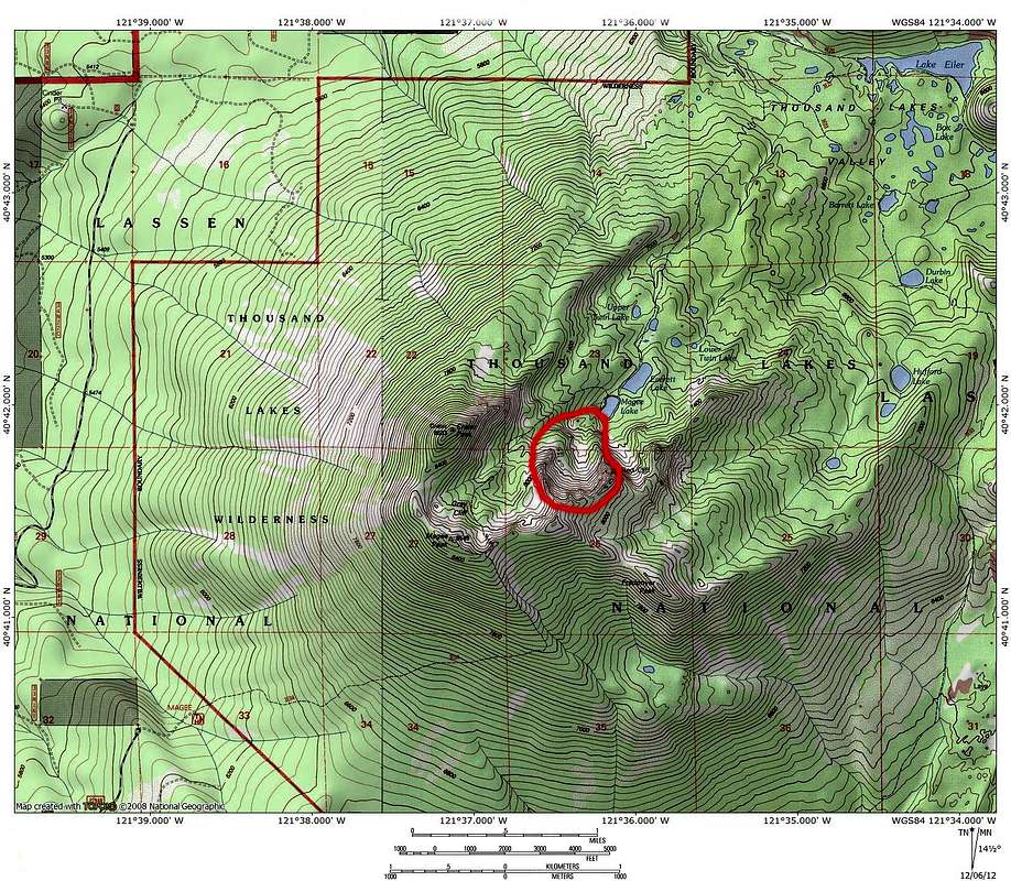
Sean hit most of the salient information I think you would want to know but I would add a few particulars. First, if you want to get inside the crater and not go up the Magee Trail, then you will want to start at the Cypress Trailhead. It is the closest and provides the easiest access, as well as passing Everett and Magee Lakes, easily the prettiest spot in the area. One other small feature to consider is the Red Cliffs. There is a bowl (I always call it Red Cliff Bowl) in the cliffs that is reminiscent of Sun Bowl on Mount Shasta. I have not skied it nor do I know anyone who has but it certainly looks doable and if you were heading through, it might be worth checking out. Incidently, I am almost done with a page on the Thousand Lakes Wilderness. If you do ski it, please post something so I can reference it on the page.

Map showing Red Cliff Bowl:
Image

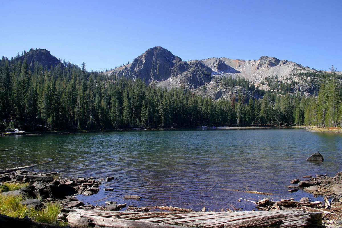
The the bowl is the large cliff to the right of the prominent tower in the center:
Image

User Avatar
jibmaster

 
Posts: 417
Joined: Sat Apr 24, 2004 10:23 am
Thanked: 39 times in 27 posts

Re: Tell me about Crater Peak

by jibmaster » Thu Dec 06, 2012 5:24 pm

It looks like the shortest distance from a road is on the south side.
By Aspan Butte. Are there any gates? Or can I drive in as far as the snow will allow?
Thanx for all the info!

User Avatar
colinr

 
Posts: 914
Joined: Tue Jul 26, 2005 8:37 pm
Thanked: 525 times in 390 posts

Re: Tell me about Crater Peak

by colinr » Fri Dec 07, 2012 10:19 am

Ahhh, yes, the Red Cliffs; that bowl does look like a good ski suggestion based on the map and photo. Bubba, I forgot you had made a page for that spot and it's also nice to hear that there will be a go to page on SP for the wilderness area. I need to allow myself enough time to tag the Red Cliffs highpoint and also to visit the lakes via the Cypress Trailhead on one of my next visits to Thousand Lakes Wilderness. Freaner Peak sounds like a nice viewpoint as well. Maybe I'll be lucky and conditions will make a visit feasible late this month.

jibmaster wrote:It looks like the shortest distance from a road is on the south side.
By Aspan Butte. Are there any gates? Or can I drive in as far as the snow will allow?
Thanx for all the info!


There are no gates in the Ashpan area (not sure about the access roads on the north and east sides of the wilderness, but I doubt it). When there is enough snow, I recall seeing a roadblock plowed to keep people from trying to drive on what becomes snowmobile trails. The shortest (but not the most scenic) route to the rim from a trailhead is the Magee Trail mentioned above. Closed/snowed in access roads and/or cross country travel might make other approaches more appealing as far as distance, but off trail travel might not be easy going in very many areas. I'd guess that the major forest roads are not yet blocked by snow and are still seeing a small amount of traffic. The area is well signed. Checking my summit logs for Crater and Magee on SP, I did run into snow and downed trees that were worth stopping and parking for on the short spur road that leads to the Magee Trailhead last December. The main forest road from Ashpan ranged from snow free, to snow and ice that was manageable with 4 wheel drive and decent tires. I carried chains just in case. I'd guess that Cypress Trailhead is most likely to remain snow free the longest. These links might help with estimating likely current conditions, but beware the area northwest of Lassen you are aiming for was colder on my visits than the area pictured in the Caltrans Cam, besides not being paved, nor plowed:

1. You can click on the cam at 5,800 feet near Lassen's NW entrance south of Ashpan on HWY 44 near the junction with HWY 89-- http://www.dot.ca.gov/dist2/cctv/shastaco.html

2. Lassen conditions & webcam at Manzanita Lake (5,850 feet), as well as higher spots (phone number provided for updated NP trail info.)-- http://www.nps.gov/lavo/planyourvisit/current_conditions.htm. -- it looks snow covered at 6,700 feet in SW Lassen and a sensor is indicating about 6 feet of snow on Lower Lassen Peak at 8,250 ft.

User Avatar
colinr

 
Posts: 914
Joined: Tue Jul 26, 2005 8:37 pm
Thanked: 525 times in 390 posts

Re: Tell me about Crater Peak

by colinr » Fri Dec 07, 2012 6:04 pm

You'll be near SETI: http://www.redding.com/news/2012/dec/06/new-hat-creek-receivers-will-let-seti-delve-into/

I've yet to see anyone, nor any large animals while in the Thousand Lakes Wilderness, but who knows? Maybe you'll get more than you bargained for on your visit. :wink:

[youtube]http://www.youtube.com/watch?v=S4PYI6TzqYk[/youtube]

Let us know how it goes if you make it up there.

User Avatar
jibmaster

 
Posts: 417
Joined: Sat Apr 24, 2004 10:23 am
Thanked: 39 times in 27 posts

Re: Tell me about Crater Peak

by jibmaster » Fri Dec 07, 2012 6:19 pm

I seen those receivers on Google Earth. Looking to get in there sometime this winter. Got a bunch of time off in Jan. But it looks doable with only a few days off.
Still waiting for more snow...

User Avatar
Bubba Suess

 
Posts: 726
Joined: Tue Oct 04, 2005 9:15 pm
Thanked: 183 times in 105 posts

Re: Tell me about Crater Peak

by Bubba Suess » Wed Jan 16, 2013 4:43 am

I do not know how useful this is, but I just posted a page on the Thousand Lakes Wilderness.


Return to California


  • Related topics
    Replies
    Views
    Last post

Who is online

Users browsing this forum: No registered users and 0 guests

cron