
-
 6631 Hits
-
 72.08% Score
-
 2 Votes
|
|
Mountain/Rock |
|---|---|
|
|
20.42943°S / 43.47466°W |
|
|
Ouro Preto |
|
|
Hiking, Mountaineering, Trad Climbing, Sport Climbing, Toprope, Bouldering, Big Wall, Scrambling |
|
|
Fall, Winter |
|
|
5840 ft / 1780 m |
|
|
Overview
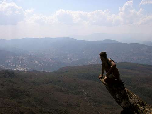
Pico do Itacolomy ( 1780m ) is the highest peak of Serra do Itacolomy ( Ita=Pedra=Rock and Colomy=Filho=Son ), Minas Gerais State. This mountains are the first group of Serra do Espinhaço, the greatest range in Brazilian territory. Localized in the south border, Itacolomy is in the transition of Mantiqueira Range and Espinhaço and divides Atlantic Forest to Cerrado Forest. Itacolomy is surrounded by other great mountains, like Itacolomy Towers ( E ), Serra de Ouro Preto ( W and N ) and Lavras Novas Mountains ( S ). The rock formation is singular, having spires with more than 300m of height ( not common in this region ) and highfields with needles arising from the mountains, pointing to the west.
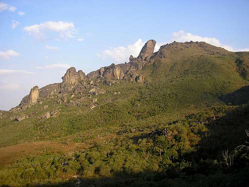 Itacolomy Massif
Getting There
Itacolomy is in Ouro Preto town, 100 km of distance from Belo Horizonte, Minas Gerais State capital. Driving from BH, take BR-040 to south ( Rio de Janeiro ) and drive 30 km till the entrance of the road to Ouro Preto and Mariana ( Historical towns of Minas Gerais ) called BR- 356 . Drive more 77 km to arrive in Ouro Preto and stop your car at the Hospital parking car. The trail starts in front of the municipal hospital, at left from Itacolomy State Park entrance. The trail have 12 km and cross 3 mountains until the Itacolomy massif, with moderate difficult in the beginning and turning a hard walking in the final sections. All of the trail is possible to see the way and the mountain, making easy the ascent to the summit.
 The road to Ouro Preto
Minas Gerais State Minas Gerais State - Road Map
Red Tape
The access is free but, it’s necessary to communicate the Itacolomy State Park about your intentions to trekking over the mountains. Do not take values equipments with you, because there are another entrances out of bounds of State Park and, turning the region not safety. The trail to Itacolomy from the State Park is close, because this problems with security, the government want to exempt of any problems.
Camping
Pico do Itacolomy have good areas to camp all over the trail, included on the summit ( in my opinion – the best place ). There are 3 points of water on the trail, but I recommend to bring your own water.
When to Climb
Pico do Itacolomy is an easy mountain to climb and, if you want to go up and go down in the same day, start early morning because at afternoon could rains hard, because the heat. The best season to camping on the mountain is in the Winter ( June to September ). The temperatures can drop down to – 5°C at Winter nights and reach 40°C at Summer days.
 Great rocks to climb close Itacolomy
Weather Conditions Ouro Preto Weather
Climbing Routes
I will search informations of routes in the Itacolomy spire. There aren’t any sources in the Internet or books. I’ll contact the Mineiro Trekker Club to send me any informations of climbing in Itacolomy region.
Links
Photos of Ouro Preto and Itacolomy