
-
 44320 Hits
-
 91.13% Score
-
 34 Votes
|
|
Area/Range |
|---|---|
|
|
45.56022°N / 113.04932°W |
|
|
Hiking, Mountaineering, Trad Climbing, Scrambling |
|
|
11154 ft / 3400 m |
|
|
Overview
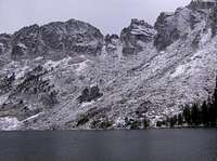
Southwest Montana's Pioneer Range is separated into the East and West Pioneer Ranges by the Wise River and the Pioneer Scenic Byway. The West Pioneer Mountains are gentle and have no peaks above timberline. The East Pioneers are a jagged line of 10,000ft and 11,000ft peaks. The Pioneers lie north of Dillon, southwest of Butte, and southeast of Wisdom. This range sees relatively few people compared to most ranges, because of its remoteness. Every peak in the range offers an awesome view of surrounding mountains and ranges.
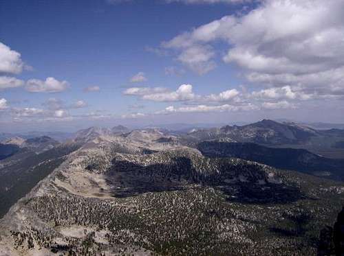
NE Pioneers from Tweedy Mountain
Looking South from Black Lion
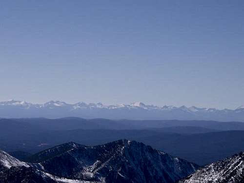
Beaverhead Mountains viewed from Granite Mountain
There are 11 named peaks over 10,400 ft in the Pioneers.
1. Tweedy Mountain: 11,154ft
2. Torrey Mountain: 11,147ft
3. Granite Mountain: 10,633ft
4. Baldy Mountain: 10,568ft
5. Alturas 2: 10,550ft
6. Barb Mountain: 10,497ft
7. Mount Tahepia: 10,473ft
8. Mount Alverson: 10,467ft
9. West Black Lion Mountian: 10,432ft
10. Highboy Mountain: 10,431ft
11. East Black Lion Mountain: 10,419ft


Accesses
The Pioneer Mountains have many good roads to trailheads.
The Apex Road (exit 74 I-15) branches off into Birch Creek, French Creek, and Willow Creek Roads. Birch Creek Road leads to Dearhead Lake trailhead, Pear Lake motorized trail, and Minneopea Lake trailhead. Willow Creek Road leads to Gorge Lakes trailhead, Tendoy Lake motorized trial, Rainbow lake and Lake Agnes trailhead, and Waukena Lake trailhead. French Creek Road heads south through the mountains and connects with Argenta Road, which leads to Dillon.
Quartz Hill road heads south after it takes off from Hwy 43. It goes by a few silver mines, goes through Vipond Park and connects to Canyon Creek Road.
Trapper Creek Road takes off from Melrose and goes almost all the way up Trapper Creek. Several old mining roads wind around the valley where Trapper Creek Road ends. Trapper Lake is about a mile from the end of the road.
Trapper Creek
Canyon Creek Road branches off of the Trapper Creek Road about 3 miles from Melrose. Canyon Creek Road ends at the Canyon Creek Ranch and a trailhead. The trail leads to Grayling Lake, Lion Lake, Canyon Lake, Abundance Lake, and Crescent Lake. There is also a group of old charcoal kilns along the Canyon Creek Road, they look like large beehives, but they are starting to fall apart.

Canyon Creek Rd.
Several Trailheads take off from the Pioneer Scenic Byway. Mono Creek trail leads to Torrey Lake.
Alpine Trad and Rock Climbing
Highboy Spire and the NW Ridge of Tweedy Mountain offer class 5 climbing on decent rock.
The NW Ridge route of Tweedy is a few pitches long, the hardest being the 5.7 parallel cracks pitch.

Highboy Spire is a prominent point on a ridge coming off of Highboy Mountain, on the Pear Lake side (NE). The Brunkhorst guide has the routes and ratings of this spire in it. (I don't have the guide yet, so I won't give you the wrong route beta)

The ridge above Lion and Grayling Lakes and Mt. Tahepia could offer some alpine trad routes.
Ridge above Grayling Lake
Canyon Creek has a 400+ft limestone cliff, which could be climbed, the trouble is you'd have to find a solid line. Most of the limestone is either blank or made of rotten limestone, but there are some spots of good rock.

cliff in Canyon Creek
Maiden Rock is another area that could offer some great climbing. It is a gnarly series of limestone faces along Canyon Creek. It is filled with holes and amphitheater like shelters. Maiden Rock is located in the foothills of the Pioneers, near the connection of Canyon Creek and the Big Hole River. I've been told that it is getting established, but I haven't found any bolted routes there yet.
To the east of the northern end of the Pioneer Range, just across the Big Hole River lies Humbug Spires, which offer almost limitless rock climbing.
Lakes, Rivers, and Fishing
The Wise River offers some great flyfishing, there are many fishing accesses located along the Pioneer Scenic Byway.
There are over 30 lakes in the Pioneers. Most of the lakes and streams in the Pioneers contain either grayling, cutthroat, rainbow, or brook trout.


----------------------------------------------------------------------------------------------------------------------------


----------------------------------------------------------------------------------------------------------------------------


Mines
There are many abandoned gold and siver mines scattered thoughout the Pioneers. Caution should be taken when approaching mines and walking in areas around mines. There are many unmarked and open pits and shafts in the Pioneers.

mine shaft
Trapper Creek is one of these areas. Hecla Mine, Keokirk Mine, Franklin Mine, Trapper Mine, and Cleve Mine are all in Trapper Creek.
Trapper Creek
Along with abandon mines comes ghost towns. The Coolridge ghost town is located off of the southern end of the Pioneer Scenic Byway in the East Pioneers.
Camping
There are a few established campgrounds in the Pioneers.
Mono Creek Campground- along the Scenic Byway
Dinner Station Campground- on Birch Creek Road.
Camping is allowed in unestablished areas along roads.
Watch for fire restictions.
Other Recreation
During the winter the Pioneer Scenic Byway isn't plowed and offers snowmobiling. Elkhorn Hot Springs offers lodging.
Rockhounding: Crystal Park, located along the Pioneer Scenic Byway, allows people look for sapphires and crystals. Black Lion Mountain has areas where you can look for crystals and different ores, such as copper and silver ores.
Caving: there are 2 known caves in the Pioneer Mountains, Argenta Cave and French Creek Cave.
Argenta cave is a fairly large cave (805ft of explored passages) with many speleothems and possible new passages. The entrance is a 40ft vertical pit and a rope is needed to enter.


French Creek Cave is one of Montana's largest caves, with some unexplored passages. The entrance of the cave is located in the back of a gold mine (gold has been found in the cave), which is part of the Park Mine. Exploration of this cave required ropes. Unfortunately the entrance to the cave has been bulldozed by the owner.
For Skiing, check out Maverick Mountain Ski Area on the south end of the West Pioneers.
Sources
1. Big Sky Fishing.com, "Fishing and Hiking in the Pioneer Mountains"
2. Newell Campbell, "Caves of Montana" 1978.
Information
The Pioneers Mountains are part of the Beaverhead-Dearlodge Ranger District. For information contact these offices:
Dillon Office:
420 Barrett St.
Dillon, MT 59725-3572
Phone: (406) 683-3900 or
(406) 683-3913
Wise River Ranger District
P.O. Box 100
Wise River, MT 59762
Phone: (406) 832-3178
District Ranger: Charlie Hester
Wisdom Ranger District
P.O. Box 238
Wisdom, MT 59761
Phone: (406) 689-3243
District Ranger: Dennis Havig