Rila National Park
Rila National Park, the largest national park in Bulgaria, is located about 100 km south of Sofia town (capital of Bulgaria), in the central and highest regions of the Rila Mountains, on the north from Pirin National Park and on west-northwest from Rodopi National Park. Mt Rila is with it's highest peak Musala (2925 m) also the highest mountain in East Europe & Balkan Peninsula.
The Park contains large meadows, over 100 peaks above 2000 m, as well as a variety of rock faces, precipices, caves, deep canyons, and waterfalls. Its territory is dotted with about 120 lakes - 70 date back from the Ice Age.
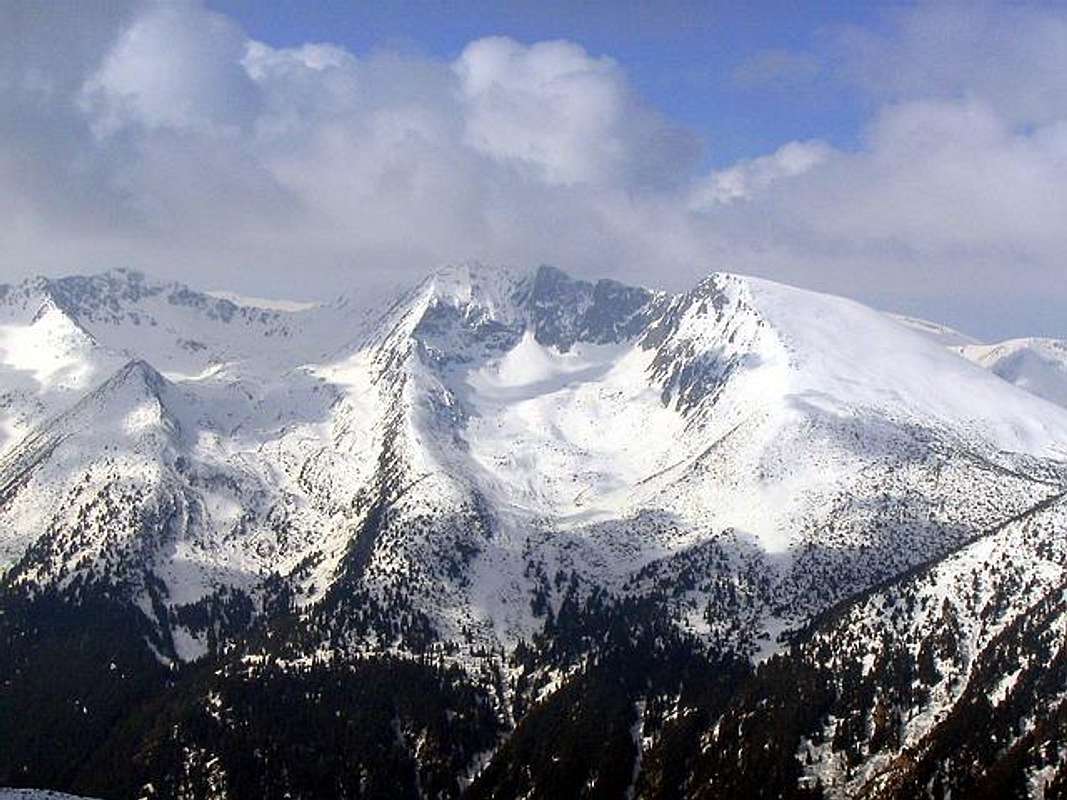
![Rila massif]()
Rila massif
The highest peaks of Rila massif are Musala (2925 m), Malka Musala (2902 m) and Irecek (2852 m).
With it's forests, mountain peaks, lakes, valleys and rivers, Rila is a ideal place for hiking, mountain climbing and skiing.
Rila National Park is located in the Rila Mountains, between 41° 53’ and 42° 19’ north latitude and 23° 07’ and 23° 55’ east longitude, in the southwestern region of Bulgaria. It comprises the treeless areas along the mountain ridge and sections of the coniferous forests below it. Its territory occupies 30% of the entire mountain. The mountain peaks along the main ridges rise to an average height of 2700 m above sea level and includes the highest peak in the Balkan Peninsula: Musala (2925 meters).
The oldest name of the mountain is "Dounkas", given to it by the Thracians. It means a place with a lot of water. Thracian is it's other name Roula, which was altered by the Slav to Rila. There are claimed to be 140 lakes in the Rila, and have given the mountains their name. "Rila" is an ancient Thracian word meaning "mountain full of water". Few ranges in Europe have so many rugged peaks; 132 peaks over 6500 feet and 78 peaks over 8000 feet. The highest is Musala (2925 m - 9397ft), the highest in south-east Europe.
The key constructive element in the mountain is granite. There are also marble, crystalline schists and others here. The twofold glaciating of Rila played an important part in the formation of its relief. The multitude of cirques, the well outlined trog (glacial) valleys, the Alpine peaks and the glacial lakes are evidence for this.
Rila has the following boundaries (clockwise): on the north - the Dzhubrena River, the Klisura Saddle and the Klisurchitsa River separate it from Verila Mountain. The Samokov Plain, the Bistritsa River, the Borovets Saddle, the Malka Slivnitsa, Slivnitsa and Maritsa Rivers (the Maritsa River up to Dolna Banya) separate it from Ihtiman Sredna Gora Mountain. Kostenets-Dolna Banya mountain valley, the Maritsa River up to its overfall with the Yadenitsa River separate Rila from the farthest south-eastern sprouts of Ihtiman Sredna Gora Mountain. On the east it borders on the Rhodopes through the Yadenitsa and Yundolska Rivers, the Yundola Saddle, Lyuta River, Avramov's Saddle, the Dreshenets River and the Mesta River to Razlog mountain valley. On the south - Razlog mountain valley. It is separated from Pirin through the Rablevska River, Predel Saddle, and the rivers of Kulina, Elovitsa and Gradevska. On the west - the Valley of the Struma River from the overfall with the Gradevska River to the overfall with the Dzherman River. The valley of the Dzherman River from the overfall with the Struma River to the Dupnitsa Plain.
Within the so outlined borders Rila occupies the area of 2396 square kilometres.
On the basis of its orographic structures and characteristics and morphographic features the mountain is divided into 4 main parts - Eastern, Middle, North-Western and South-Western. The following rivers serve as their borders - Cherni (Black) Iskar, Levi (Left) Iskar, Beli (White) Iskar, Rilska, Iliina, Belishka and Stankova as well as the ridge saddles - Kobilino Branishte, Kadiin Grob and Gorni Kuki. Each of the main parts, on its part, is subdivided into several subparts bearing the names of the highest or central peak.
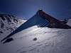
1. Eastern Rila is the highest (absolutely) and the most spacious of the 4 main parts and it comprises 37% of the total area of the mountain. Eastern Rila on its part is divided into 7 subparts. Three of them - the Musala, Maritsa and Kovashki are situated on the Moussala gorge and the remaining 4 - Slavov's, Belmeken, Ibur and Mustachal on the Ibur main gorge. The two main gorges cross at the junction Mt. Marishki Chal, situated at the main watershed on the Balkan Peninsula, between the water catchment areas of the Iskar, Maritsa and Mesta Rivers. The 11 highest peaks of the mountain steeper in Eastern Rila headed by Musala (2925.4 m). The second – Mt. Malka (Little) Musala (2902 m) is situated to the east (they are linked by the narrow rocky edge Trionite (the Saws). The third highest and unique between the altitude of 2800 and 2900 metres – Mt. Irechek (2852 m) is next to them too. The lake groups of Moussalenski Ezera (“ezera” meaning lakes), Marichini Ezera, Ropalishki Ezera, Yakoruda Ezera and others are in this part as well. The highest lake in Rila is within the Moussala group - the Glacial Lake (2709 m), situated in the immediate proximity on the north under Mount Musala. There are 9 tourist chalets and 2 high-mountain shelters in Eastern Rila. The highest meteorological station in South-Eastern Europe, built in 1932 is situated on the Musala.
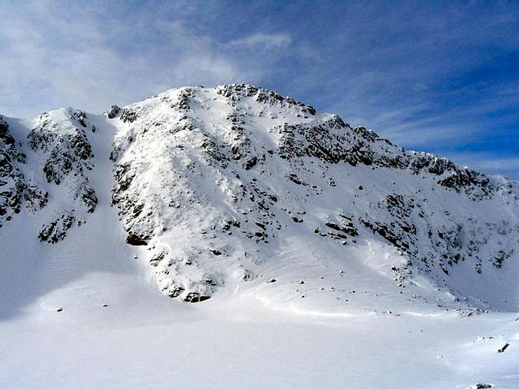
![Rila winter scenery]()
Eastern Rila winter scenery
2. Middle Rila is the smallest part of the mountain - it occupies only 9% of its area. Its relief, however, is the most Alpine with the average altitude above sea level - 2077.17 m. Middle Rila has two main ridges - Skakavishko and Riletsko separated by the valley of the Rilska River. They are linked by Mt. Kanarata (The Rock) (2691м), occupying a focal place in the orohydrographic characteristics of the whole mountain, known as the “navel” of Rila. Three subparts are outlined along the Skakavishki Main Ridge - Skakav, Marinkov and Shishkov. There are 3 subparts along the Rilets Ridge, too - Kanara, Rilets and Brichebor, i.e. Middle Rila has 6 subparts. The highest peak is Mt. Karaalanitsa (Black Meadow) - 2716 m (14th highest in Rila). The following peaks are remarkable, too: Mt. Rilets (2713 m), Mt. Yosafitsa (2697 m), Mt. Aladzha Slap (2684 m), Mt. Vodniya Chal (Water Peak) (2683 m). Middle Rila is rich in glacial lakes. Here are: the Fish Lakes, Prekorech Lakes, Mermer Lakes, Karaomerish Lakes, Dzhendem (Hell) Lakes, the Monastery Lakes. The biggest glacial lake on the Balkan Peninsula - Smradlivoto (Srinking) with the area of 212 decares is also in this part of the mountain. There are 3 chalets in Middle Rila and one high-mountain shelter.
3. North-Western Rila, which is divided into low and high (Alpine) parts, occupies 24% of the total area of the mountain and is the third biggest in relation to the average altitude above sea level, too - 1555.73 m. Its low part comprises the oblong Govedartsi mountain valley and the so-called Lakatish Rila, which is a fore-mountain of the main massif of Rila. The high (Alpine) part is divided into Malyovitsa, Damga, Kalins, Otovish and Kabul subparts. The most prominent Alpine sites of Rila and Bulgaria are located in the Malyovitsa subpart. These are the peaks: Mt. Malyovitsa (2730 m) - the symbol of Bulgarian alpinism and mountaineering), Mt. Kupenite (the highest of them – Mt. Great Kupen is the highest peak in North-Western Rila - 2731 м), Mt. Elenin, Mt. Orlovets, Mt. Zliya Zub (Evil Tooth), Mt. Dvuglav (Two-headed), Mt. Lovnitsa, Mt. Petlite (Roosters), Mt. Orleto (Little Eagle) and a number of others. Some of the biggest and significant lake groups are situated in this part of the mountain – Urdini Ezera, Malyovshki Ezera, Elenski Ezera, Gradinski Ezera, Popovokapski Ezera, as well as the biggest and most famous lake group on the Balkan Peninsula – Sedemte Rilski Ezera (The 7 Rila Lakes). There are 10 tourist chalets and 2 high-mountain shelters built up in North-Western Rila.
4. South-Western Rila comprises 30% of the mountain - the lowest part with the average altitude above sea level of 1306.63 m. It is divided into two main ridges - northern, consisting of Mechi Vruh and Tsarev Vruh subpart and southern, divided into Parangal, Kapatnik and Hurs. Mt. Angel is the highest in this subpart (2643 m). Some of the more remarkable peaks here are Mt. Goliam Mechi (Big Bear) (2618 m), Mt. Uzunitsa (2606 m), Mt. Tsarev Vruh (Tsar's Peak) (2378 m), Mt. Kapatnik (2170 m) and others. There are 2 tourist's chalets in South-Western Rila. One of the oldest biosphere reserves in Bulgaria is located on the territory of this part - Parangalitsa, known also for its centuries-old spruces.
Some of the most well-known Bulgarian rivers flowing their waters in the direction of both the Black Sea and the Aegean Sea spring from Rila, i.e. the main watershed of the Balkans passes through it. Solely the Iskar River drains into the Black Sea, but its water catchment area in Rila is big enough including its initial tributaries Cherni (Black), Beli (White) and Levi (Left) Iskar as well as a lot of other smaller ones. The Chanakski Ezera (Chanak Lakes) in North-Western Rila are considered as the origin of the Iskar River near the cirque of the 7 Rila Lakes. The longest Bulgarian river - the Maritsa River as well as the Mesta River empty in the Aegean Sea, beyond the territory of Bulgaria. The first flows out of Marichini Ezera (Maritsa Lakes), south of Mt. Moussala, and the second drains the southern slopes of Eastern Rila. The water catchment area of Struma River (taking its rise from Vitosha Mountain) is spacious, too. It catches the waters of the western and south-western slopes of Rila and also empties into the Aegean Sea, on the territory of Greece. Among its Rila tributaries of greater importance are the Rila River, the Dzherman River, the Dupnitsa River and the Blagoevgrad Bistritsa River.
Rila National Park was established on February 24, 1992 to conserve the natural heritage of the Rila Mountains as well as the local traditions, culture, and livelihoods linked with the area. The National Park Directorate, a regional body reporting to the Ministry of Environment and Waters, manages the Park. The Directorate engages local organizations and volunteers to pursue its goals.
Park Statistics:
Area: 81,046 hectares
Highest elevation: Musala at 2,925 meters above sea level
Lowest elevation: the area above Blagoevgrad, at 800 meters above sea level
Wooded area: 53,481 hectares
Treeless areas: 27,565 hectares
90% of all ecosystems are natural
There are four nature reserves, with a combined area of 16,222.1 hectares
Protected Area:
Rila National Park is one of the largest and most valuable protected areas in Europe—listed as Category 2 by the World Conservation Union (IUCN). The Park and all four of its nature reserves are on the UN List of Representative Protected Areas. The Parangalitsa Reserve and the former Marichini Ezera Reserve (now incorporated in the territory of Central Rila Reserve) are part of the World Biospheric Reserves Network under the UNESCO Man and Biosphere Program. Central Rila is the largest nature reserve in Bulgaria and covers a total area of 12,393.7 hectares. Parangalitsa, designated in 1933, is one of the oldest Bulgarian nature reserves.
Ecosystems:
Most of Rila National Park is covered in thick forests—primarily spruce, white fir, and Macedonian pine. The higher plant species identified thus far, within the park, constitute 38.35% of the higher flora of Bulgaria.
There exist:
- 57 endemic species (of limited geographic range)
are local endemic species
- 18 are Bulgarian endemic species
- 36 are Balkan endemic species
- 105 relict species (survivors from past geological ages), of which 74 dating from the Ice Age, and 31 from the Tertiary Age.
- 98 are listed in the Red Data Book of Bulgaria (13% of all those listed).
Of the 141 species of medicinal plants, 20 are listed in the Red Data Book, while 8 are protected under the Environmental Protection Act. In addition, Rila National Park is home to 282 species of moss, 233 species of mushrooms (11.6% of all identified in Bulgaria), and 130 species of freshwater algae.
This part of Rila Mountain is home to 2,934 invertebrate and 172 vertebrate species of the Bulgarian fauna. There are 99 species of nesting birds (30% of all known in Bulgaria), of which all but 5 are protected. Many of the vertebrate species within the Park are protected:
- 121 species are listed in the Red Data Book of Bulgaria
- 24 are on the World Conservation Union (IUCN) Red List
- 158 are on lists under the Bern Convention.
Of the invertebrate fauna, 41 organisms are included in world or European lists of endangered species.
The EU-funded CORINE BIOTOPS Project created a habitat classification methodology and 60 of the CORINE classified types of habitats are represented in the Rila National Park. Of these, 29 are included on the List of Endangered Habitats, requiring special protection measures pursuant to the EU Convention on Habitats and Resolution 4.
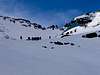
Seven Rila Lakes Valley
![7 Rila Lakes Valley]()
Beautiful scenery of 7 Rila Lakes Valley
The cirque of the Seven Rila Lakes is the largest in all of Rila Mountain. It is centered East of Haidyta Peak (also known as Hermit Peak) and South of the steap rock slopes of Razdela Ridge and Otovishka Peak, found to the West of the peak directly above Kidney lake. The cirque opens to the North and feeds the German River, which is a main source of the Stryma River. The lakes of the cirque are found at differing altitudes and appear like large footprints or steps leading up the mountain. They are the most picturesque and visited group of lakes in Rila Mountain. They are all named according to their shapes and officially numbered from the top to the bottom. The entire area is maintained within the boundaries of Rila National Park.
The Seven Rila Lakes is an extremely sensitive and wonderous spot on Rila Mountain. Many of its species are endemic and listed in the Red Data Book of Flora and Fauna, which denotes them as endangered or rare.
The 1st - “Salzata” (The Tear ) is the highest of the Rila Lakes. It is found at 2535 meters above sea level and has an area of .7 hectares. It is 4.5 meters at its deepest.
The 2nd - “Okoto” (The Eye) is found at 2440 meters above sea level and has an area of 6.8 hectares. It is the deepest of thelakes with a depth of 37.5 meters.
The 3rd - "Babreka" (The Kidney) is at an altitude of 2282 meters above sea level and has an area of 8.5 hectares. It is 28 meters at its deepest.
The 4th - "Bliznaka” (The Twins) are actually one lake nearly split into two. They are at 2243 meters above sea level and is the largest and longest of the lakes. It has an area of 9.1 hectares and a depth of 27.5 meters.
The 5th - "Trilistnika" (Three-Lobed Lake) has an irregular shape and steep banks and is found at 2216 meters above sea level. It is 6.5 meters deep and has a total area of 2.6 hectares.
The 6th - "Ribnoto" (The Fish Lake) is found at 2184 meters above seal level and has an area of 3.5 hectares. It is the shallowest of the lakes at 2.5 meters. The 7 Lakes Lodge is found at its most Northern bank.
The 7th - "Dolnoto" (The Low Lake) is at 2095 meteres above sea level, has an area of 5.9 hectares and is 11 meters deep.
![7 Rila Lakes Valley]()
![7 Lakes Valley]()
![7 Rila Lakes Valley]()
![Okoto Ezero]()
Borovets
RILA massif is a ideal place for hiking, mountain climbing and skiing. Only 70 km from Bulgarian capital Sofia is a beautiful mountain town and ski resort - Borovets (1350 m).
Borovets is the oldest and the biggest mountain resort in Bulgaria. Lots of world ski championships were organised here. It is located at 1350 m above the sea level on the northern slopes of Rila mountain among age-old pine woods, at the foot of peak Musala (2925 m) the highest one on the Balkan peninsula. Borovets is easily accessible, being at a distance of 73 km from Sofia (the capital of Bulgaria) and 126 km from Plovdiv. The nearest town is Samokov, which is 10 km far from the resort.
At 1,350 metres (4,430 feet) above sea level on the northern slopes of Rila Mountain, among age-old pine woods, Borovets is located at the foot of Moussala peak (2,925 metres / 9,600 feet) - the highest on the Balkan Peninsula. Borovets is easily accessible, being at a distance of 73km (45 miles) from Sofia and 126km (79 miles) from Plovdiv, Bulgaria's second city. Although Borovets is not residential, the town of Samokov is only 10km (6 miles) along the road from the resort.
Established at the end of the 19th century as a hunting place for the Bulgarian kings, Borovets gradually developed into a modern ski resort of high-class and luxury hotels, haute-cuisine restaurants and an excellent network of ski runs and lifts along the slopes of Rila Mountain, providing excellent opportunities for the whole range of winter sports — from Alpine to cross-country skiing, ski jumps and biathlon. The resort twice hosted World Cup Alpine skiing rounds, while the biathlon track is one of the best in the world.
The ski runs are of various difficulty, and are suitable for all, be they beginners, intermediate, advanced or expert skiers. The slopes and runs are maintained in perfect condition, and are designed with international markings and multilingual signs. A snow machine is also used.
The Borovets ski school, with more than 200 ski instructors, enjoys international prestige and long-standing traditions. All of them are fluent in different languages, and many are former professional skiers. Skiing classes are at 5 levels of difficulty, from A to E - in groups or individually - 4 hours per day, for 6 or 12 days. Cross-country skiing classes are for 2 hours daily. All course graduates receive skiing certificates.
Borovets has ten ski rental services, located next to the lift station around the ski runs. They offer 7,000 sets of skiing equipment from world famous companies, as well as toboggans, sledges, etc. Skiers can also leave their own quipment for safekeeping there.
A ski package is available, with a view towards saving time and money, and covers ski school classes, unlimited lift usage, ski and boot hire or storage of one's own skiing equipment.
The Ski Patrol, based at the first station of the cable lift, provides a round-the-clock emergency service. It is organised in four teams, fully equipped with all necessary equipment, including a helicopter, if needed. The air in Borovets is crystal clear and totally free of any pollutants, while the average temperature during January, the coldest month, is -4.6ºC.
The Peter Popanguelov (famous former Bulgarian ski star) Ski School for Expert Skiing and its 10 highly qualified ski instructors are ready to offer their services to those who want to hone their skiing skills to world championship level.
Toboggans, swimming pools, saunas, fitness centre, billiards, table tennis, bowling, sleigh rides and helicopter flights are some of the activities on offer. In 2007 golf should be added to this list.
During the summer, Borovets offers walks along scenic routes, including many ski-routes, in groups led by experience guides. Organised trips lead to picturesque spots in the Rila Mountains, such as Seven Rila Lakes, Malyovitsa peak, Moussala peak, etc. A photo safari and a visit to the Bulgarian kings' resience of Bistritsa are also organised regularly.
Voted "Best for intermediates" by the Daily Mail, 13 November, 2004: "Adept marketing in recent years has given this Bulgarian destination the highest profile of all Eastern European resorts... Its 40km of pistes offer more challenge than any others in Bulgaria... Both main ski schools have a reputation for friendly instruction, and the standard of rental equipment has vastly improved in recent years."
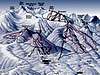
![Borovets Ski Infrastructure]()
Getting There
Gateway to Rila National Park is Borovec (1350 m) town, famous Bulgarian ski resort.
Look Borovets Webcam!
By plane:
To Sofia Airport, Sofia town - capital of Bulgaria. Information about flights to Sofia on Balkan Bulgarian Airlines.
By train:
Sofia - Kostenec: 74 km (1.15h - 1.55h by train)(Sofia - Plovdiv line). From Kostenec to Borovets by local bus or by taxi.
Information about train on Bulgarian Railway timetable. Combine Sofia - Kostenec. Approximately time of this train distance: 1.15h - 1.55h.
By bus:
Sofia - Samokov - Borovets
Information about bus lines and tickets.
By car:
Sofia - Samokov - Borovets. Road Nr. 82 Sofia-Kostenec (70 km).
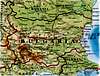
![Bulgaria Map]()
![Rila Map]()
Routes Overview
MUSALA (2925 m):
1. Borovets - Musala (2925 m): Borovets - Bistrica village - Velcevo Mostce - Musala hut - Ledenoto Ezero - Ledenoto Ezero hut - Musala (2925 m): 6-7h
2. Borovets - Deno - Irecek - Malka Musala - Musala: Borovets - Deno (2790 m) - Sfinksa - Irecek (2852 m) - Malka Musala (2902 m) - Musala (2925 m): 7-8h
If you are short on time, you can also use the gondola lift Borovets - Jastrebec (2369 m) peak and so save 3 hours of walking/hiking. Then, from Jastrebec peak till Musala summit by walk.
When To Climb
Accessible through the whole year; great ski resort(s) in the winter.
The peaks of Rila massif you can climb during whole year, but of course, the optimal period is from mid June - mid September (beginning of October), out of the season of snow on the mountain.
Camping
HUTS:
1. Hiza Musala (2430 m) (food, drinks, overnight stay),
2. Ledenoto Ezero Hut (no food, soft drinks and beer, overnight stay),
3. Musala Hut, which is located right on the peak (no food, you can buy water in plastic bottles).
4. Central Mountaineering School "Maljovica"
-altitude - 1700m
-115 beds
-library, indoors gym with a small climbing wall, conference rooms
Contacts:
0712/ 52-270
048/ 916-266
5. "Maljovica" Hut
-altitude - 1960 m
-125 beds in two buildings
Contacts:
048 / 944-359
0887/ 570-006
6. "Rila Lakes" Hut
-altitude - 2150 m
-135 beds
Contacts:
048/ 986 796
0888 / 463 526
SHELTERS (mainly for emergency use):
1. "BAK"
(also known as "Orlovec" or "Granitna voda" (Granite water))
-situated in the dry cirque encircled by Orlovec, Zlijat Zab, Lovnica and Kamilata
-altitude - 2530 m
-may shelter up to 10 people
2. "Strashnoto ezero" (Scary lake) Shelter
-situated on the Northern shore of the lake, below Kupenite
-altitude - 2465 m
-may shelter up to 20 people
Also, you can stay in Borovets town or in Bistrica village (in hotels or in private apartments or rooms) and start from there your climbing routes on Mt Rila.
![Hiza Musala]()
![Hiza Musala]()
![Hiza Musala]()
Mountain Conditions
The climate of Rila is determined by its geographical situation, on the border between the continental and the transitional Mediterranean climate and the microclimate - by the altitude zones and by the soil and vegetation cover.
The lowest average monthly temperature was recorded during the month of February on the mount of Moussala - 11.6°С below zero. The absolute minimal temperature so far in Bulgaria was measured in the same place - 31.2°С below zero (during February). During the month of August the average temperature of the mount is 5.4°С and the absolute maximal temperature measured on Moussala is 18.7°С.
The average annual temperature is -3.1C, and the snow-cover lasts 8 months per year.
The winds in Rila blow predominantly from the west and the south-west. There are rarely north-western and north-eastern winds and they are more moderate, and the northern, southern and south-eastern winds do not play an essential role. The quantity of precipitation is significant, about 1200 mm fall on Moussala per year, about 80 per cent of them being snow. The snow cover on the parts of average altitude and the Alpine parts of the mountain often exceeds 2 metres. All these enumerated climatic factors create prerequisites, mostly in the Alpine parts of the mountain, for avalanches.
MUSALA WEATHER FORECAST
weatheronline.co.uk
weather.digsys.bg
Red Tape
No fees required.
No permits needed either.
Usual rules of behaviour for NP's do apply.
The only tax one may have to pay is the parking taxes in, if came by car/van, etc. But they're insignificant (approx 2 EUR per 24hrs).
External Links


Tarambuka3500 - Sep 25, 2003 9:50 am - Hasn't voted
Untitled CommentThat was a period of 500 years, which started some 700 years AFTER (!) establishment of the Bulgarian Kingdom.
So Bulgaria just REGAINED its independency, in the 1800s, unfortunately in way-smaller size than it had been in the 14th century.
gordonye - Jul 25, 2002 11:25 am - Hasn't voted
Untitled CommentBulgaria was ruled by Ottoman Empire of Turkey as recent as late 1800's before it became independent.
gordonye - Nov 6, 2002 5:01 pm - Hasn't voted
Untitled Commentfor Mussala: 42.1833 lat, 23.5833 long
http://www.me.umn.edu/~curt/weather/data/stnlist-sorted.txt
notracks - Sep 17, 2003 1:08 pm - Hasn't voted
Untitled CommentAnother popular starting point for Rila is the town of Dupnica - about 2 hours by train south of Sofia . If you want to hike in the Western part of Rila (including "seven rila lakes"), this is where you need to start.
Tarambuka3500 - Sep 25, 2003 9:50 am - Hasn't voted
Untitled CommentThat was a period of 500 years, which started some 700 years AFTER (!) establishment of the Bulgarian Kingdom.
So Bulgaria just REGAINED its independency, in the 1800s, unfortunately in way-smaller size than it had been in the 14th century.
Tarambuka3500 - Sep 25, 2003 9:53 am - Hasn't voted
Untitled Commenthttp://www.wunderground.com/cgi-bin/findweather/getForecast?query=mussala
http://weather.digsys.bg/c/index.pl%3Fplace=48&action=real&lang=_eng.html
spellbinder - Sep 9, 2005 6:28 am - Hasn't voted
Untitled Commentyou pay for camping in Rila Mts when you do it near the challet (appr. 1 euro per tent). Night in the shelter/challet costs ca. 5 euro