
|
|
Mountain/Rock |
|---|---|
|
|
41.35914°N / 122.34966°W |
|
|
6325 ft / 1928 m |
|
|
Overview
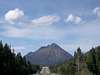
Black Butte is one of the Cascade Range's southernmost volcanoes, rising up dramatically directly next to I-5 in northern California. Black Butte is a plug dome that was formed about the same time as Shastina, Shasta's parasitic western cone. Were it not for Mt. Shasta, Black Butte would seem a great deal more dramatic than it already does. However, due to Mt. Shasta (the 2nd highest of the Cascade giants), as well as county highpoint (also the highest peak W of I-5) Mt. Eddy, Black Butte is sadly relegated to a largely secondary role. Somewhat pathetically, Black Butte's name is even largely ambiguous- another smaller Oregon Cascade volcano (near Bend, slightly higher than this one) has the same name, as well as Glenn County (CA) highpoint Black Butte (ironically, Black Butte had several other, & more distinctive, I might add, names in its past, including Muir's Peak). In the words of the late Rodney Dangerfield (RIP), "I can't get no respect..."
While all of these things are unfortunate & to some perhaps even demoralizing to (northern Californian, southern Cascade) Black Butte fans, this too often overlooked little volcanic vent has its perks as well. One can climb this imposing-looking peak via an easy class 2 trail that requires nothing more than half a day, sturdy legs, & a healthy cardiovascular system. Upon reaching the summit, one is rewarded with one of the most spectacular views possible of gargantuan neighbor Mt. Shasta, as well as Mt. Eddy & the Klamath range. Perhaps best of all, by ascending Black Butte, one is generally able to escape the overwhelming hordes of freaks generally encountered on Mt. Shasta or (to a lesser degree) Mt. Eddy.
 |
 |
 |
 |
 |
How To Get There
While one drives within spitting distance of Black Butte on I-5, getting to the parking lot at the base of its trail is a different matter.
To reach Black Butte, take the Central Mount Shasta exit from I-5 (Lake Street.) and head east towards Mount Shasta. As Lake Street turns left near a baseball park it turns into Everett Memorial Highway. From here follow Everett Memorial Highway until you cross the railroad tracks. At the tracks go 1.7 miles to the turnoff on the left. Be careful, as the signs sometimes are missing. At the time of writing this (BTW- this section mostly written & unmodified, by Shredder), it was the only road that was kept up with nice rock and graded. Follow diamond arrow signs (also sometimes missing) to trailhead. Don't try to take some of the lesser kept up roads unless you want to 4x4 and get lost.
romo provides the following information:
check this out and do not try to get there from Weed via Black Butte Rd or Black Butte Lookout Rd. There are gates and at least one locked gate.
This gives history and directions.
http://www.fs.usda.gov/Internet/FSE_DOCUMENTS/fsm9_008082.pdf
A regular car could make it as of 9/29/2015
The summit trail is basically well made, & easy to follow, but steep- two and a half miles uphill with 1,900 feet of elevation gain. This is an easy walk up a nice trail to the summit. The views of one of the Mt. Shasta, one of the Cascade's giants, are jaw-dropping (seeing it in alpenglow is a sublime experience). Going off trail is not recommended as this is obviously a giant [steep] scree pile with loose rock everywhere. I recommend a jug of water and a bit of sunscreen.
check this out and do not try to get there from Weed via Black Butte Rd or Black Butte Lookout Rd. There are gates and at least one locked gate.
This gives history and directions.
http://www.fs.usda.gov/Internet/FSE_DOCUMENTS/fsm9_008082.pdf
A regular car could make it as of 9/29/2015
 |
 |
 |
The Trail
Summer / FallThe summit trail is basically well made, & easy to follow, but steep- two and a half miles uphill with 1,900 feet of elevation gain. This is an easy walk up a nice trail to the summit. The views of one of the Mt. Shasta, one of the Cascade's giants, are jaw-dropping (seeing it in alpenglow is a sublime experience). Going off trail is not recommended as this is obviously a giant [steep] scree pile with loose rock everywhere. I recommend a jug of water and a bit of sunscreen.
As of 7/6/'20, utahjimk reports the following: "~1.5 mile from TH: trail damage. A "gabion basket" section collapsed. There is a warning sign of this at the TH. This is a section of basically chain-link steel basket that hold back the loose rock. No great deterrence though."
Climbing this in winter?
The road is snowbound during the winter snows so usually it is not climbed until the road is clear but if you do then remember the side of Black Butte is very steep and obviously the trail will be covered with snow. If snow is present then use your good judgement and use an ice axe and crampons.
Spring
During the spring there may be snow still on the trail and an ice axe may make some people feel more comfortable on the steeper sections. If you forget an axe you can sometimes find a walking stick just before the snow sections. Just use the stick as you would use the axe handle for self arrest (if you don't know what this means, perhaps you should wait until later in the season). If you do find one please leave it at the beginning of the snow section for other hikers.
 |
Weather Information
For up to date weather from a weather station at the base of Black Butte use link belowWeather
One place to double check this is the weather.com site for Mt. Shasta City weather
 |
Books
Check out this site!Mount Shasta's Black Butte
External Links
- Weather
Weather station information at the base of Black Butte - USGS
Volcano information, maps - live camera for Mount Shasta
- Highway cam at base of Black Butte
Highway cam at base of Black Butte
SpankyBob - Jun 29, 2004 12:25 am - Voted 10/10
Untitled CommentThe signs are largely down or missing. You can identify this road because it is the only dirt road from Everitt Memorial Highway that has a stop sign. (You see only the back of the stop sign). All the other roads are much less maintained. The turn off is 1.5 - 1.6 miles from the railroad crossing (according to my odometer). Follow the excellent topo map on this page for the final driving directions. The road starts to peter out towards the end, just keep following the one with the most evidence of traffic on it. The road ends with a small round about at the trail head. Parking can be tough if there are more than a few cars there.
emilie - Apr 30, 2014 5:26 pm - Hasn't voted
Road conditionsI did this this morning in my Mazda 3. Drove carefully as there are numerous potholes, but no major problems in a low clearance FWD vehicle. I didn't have any driving beta and didn't notice any signs at all. I just stayed on the main gravel road. Anytime there was a fork or a turnoff, I stuck to the more obvious choice and it took me to the small cul-de-sac parking lot just fine.
romo - Oct 5, 2015 12:17 am - Hasn't voted
road directions and historycheck this out and do not try to get there from Weed via Black Butte Rd or Black Butte Lookout Rd. There are gates and at least one locked gate. This gives history and directions. http://www.fs.usda.gov/Internet/FSE_DOCUMENTS/fsm9_008082.pdf A regular car could make it as of 9/29/2015