|
|
Route |
|---|---|
|
|
46.38178°N / 14.55688°E |
|
|
Hiking, Scrambling |
|
|
Summer, Fall |
|
|
Most of a day |
|
|
Walk up and an easy climb of UIAA I degree |
|
|
Approach
You drive to Jezersko and then on the parking place on the meadow Ravenska kočna. How to come on Jezersko read on the main page.Route Description
Soon after the parking place we see the signpost for the route on Velika Baba over Jenkova planina (meadow). So we deter left from the road and start ascending through a forrest. In good one hour we reach the nice alpine meadow where also a private hut stands, 1494m. Here is the main ridge, which comes from Velika and Mala Baba down, and continues over Goli vrh towards Jezerski vrh (saddle). By this ridge also the border between Austria and Slovenia goes. From Jenkova planina meadow we can also reach Goli vrh, 1788m, by a marked path. It is a wonderful lookout peak.
The ascent on Baba goes right, at first by the main ridge. In the beginning the path is easy, then steep sections through the woods come. On this part the path avoids the main ridge and goes over the right slopes, so on the Slovenian side. Then it reaches a steep, shallow ravine, goes through it and above turns a bit left, so we reach the main ridge. The terrain is now open and the view broader and broader. The path is well marked, but steep all the time towards the summit of Mala Baba, 2018m.
From Mala Baba the summit of Velika Baba looks close, but till there we will normally need another hour. The path first descends right down and goes below the main ridge on. Here we realise that also on harder and more exposed places the route is not protected, as it is usual in these mountains for marked paths. If there are marks, in Slovenian mountains paths get protected by artificial means when difficulties reach the climbing level of UIAA I. But not here. We move by narrow ledges, by a crumbly terrain, the route is marked, but not protected.
After crossing the slopes on Slovenian side, the route ascends again on the main ridge and goes by it steeply up. For the ascent this section is not so hard, but the depth below us is rising, and we must be careful. The next section goes by tiny ledges on the Austrian side. Here we move over a steep face, which is partially overgrown by vegetation (also dwarf pines), but that helps a little with security.
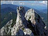
We are already very close to the main summit of Velika Baba, where we pass by a tiny ledge a ridge tower, actually this one is more recognisable, when we look back after passing it.
Now the final ascent on top starts. Here we go from the ridge point over a steep rocky part, oriented towards the north. This is the only part, which is protected by a short, but reliable cable (not any more in 2015 - now there's no trace of any protectuion at all!!!). Above we soon find ourselves on the sunny double summit of Velika Baba, 2127 m. As it was described on the main page, Velika Baba has two summits and before we come on the highest point, we reach first the lower twin summit and then the highest one. The view is magnificent.
From the parking place we need some 4 hours to reach the summit of Velika Baba. Count on also good 3 hours for a descent.
We descend by the same route but more comfortable (easier) and beautiful is the descent by Kranjska koča na Ledinah (hut) - so over the SE ridge and from the hut back on Jezersko. (see the description of that route for more details).
Description written by Bor and Vid.


