


-
 1349 Hits
-
 77.48% Score
-
 8 Votes
|
|
Route |
|---|---|
|
|
45.64911°N / 7.42811°E |
|
|
Hiking |
|
|
Spring, Summer, Fall, Winter |
|
|
A long day |
|
|
F (easy) |
|
|
Note
|
La montagna chiama i suoi figli, ed essi rispondono fedelmente al suo appello… Osvaldo Cardellina, Diario alpinistico, 1964-65 Page texts: @ OsvaldoCardellina "Osva", passed away on May 2, 2022. Page owners: Christian Cardellina e Osvaldo Cardellina. Any updates from September 12, 2022: Antonio Giani, page administrator, friend and climbing companion. Testi della pagina: @ OsvaldoCardellina "Osva", scomparso il 2 maggio 2022. Proprietari pagina: Christian Cardellina e Osvaldo Cardellina. Eventuali aggiornamenti dal 12 settembre 2022: Antonio Giani, amministratore della pagina, amico e compagno di salite. |
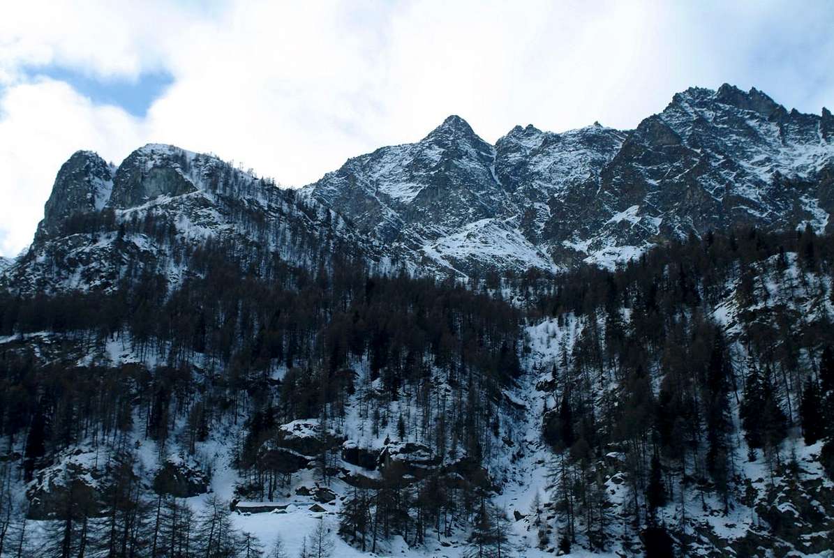
Dzimillan Overview Les Druges
A high hill (2.931m) bypassed already since many Centuries, perhaps even Millennia, then fell almost into oblivion and "rediscovered" by Mountaineers Hikers. An essential step in ancient times, adapted to connect the Central Valley of Baltea with the Valley of Cogne thus avoiding wide turn toward Aymavilles and the City of Aosta. But also a hill that lived beautiful days of mountaineering feats, not so much for the difficulty but for the adventure of a winter crossing as that carried out by Giuseppe Corona, winner of Punta Tersiva February 17th 1875, and companions from Cogne in St. Marcel during the winter of the second half of the Nineteenth Century. But also a hill, probably attended since the time of the Salassian People, that the Abbé Pierre Balthazar Chamonin, Cogne Curate-Vicar, describes enthusiastically in the "Bulletin C.A.I. 1866" as: "Ce col est un des plus faciles et des plus fréquentés de toute la vallée. Les mulets mêmes ne courent aucun danger à y passer, car son chemin, qui part de Grauson et passe au Plan des Souches, monte en pente douce le plateau du Coronas, serpente sur le lac de ce nom, puis après un petit clapej, il se relève encore légèrment à travers un pâturage que le mois d'octobre émaille de fleurs, et touche enfin le col. Le point de vue de ce col est très-beau: on y découvre tout le versant méridional des Alpes Pennines depuis le Mont Combin jusq'au Mont Rose. Mais ce surtout le Mont Cervin qui frappe le plus les regards. Il se dresse en face svelte et majestueux, il foule aux pics qui semblent des nains à ses côtes. Au levant du Col Coronas l'arête de la montagne hausse de nouveau sans cesser d'être accessible jusque tous près de la pointe du Thessonet. Ce pic est le noeud qui lie Cogne - St. Marcel et Fénis. Ses flancs sont très escarpés, on croit même qu'il soit inaccessible. A quelque distance vers son sud-est on voit la pointe Tersiva." Where once, except for us and some Poacher that it was divided between the Beck Peckoz Reserve and the Gran Paradiso Park, did not see almost nobody ...
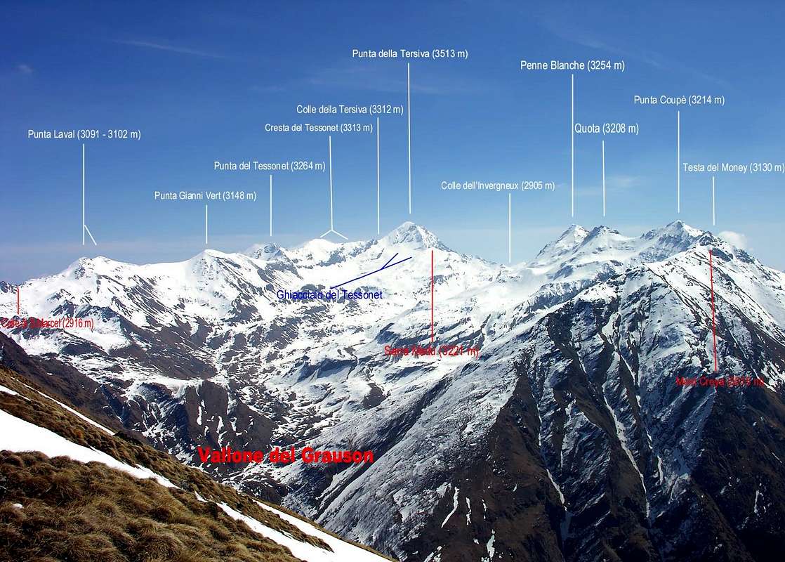
Un alto colle (2.931 m) transitato già da molti Secoli, forse da Millenni, poi caduto quasi nel dimenticatoio e "riscoperto" dagli Alpinisti nonché dagli Escursionisti. Un passaggio essenziale nei tempi antichi, atto a collegare la Valle Centrale della Dora Baltea con la Valle di Cogne evitando quindi il largo giro verso Aymavilles e la Città di Aosta. Ma anche un colle che ha vissuto belle giornate di imprese alpinistiche, non tanto per la difficoltà ma per l'avventura di una traversata invernale come quella effettuata da Giuseppe Corona, già vincitore della Punta Tersiva il 17 Febbraio 1875, e compagni da Cogne a St. Marcel durante un inverno della seconda metà del XIX° Secolo. Ma anche un colle, probabilmente frequentato già dai tempi dei Salassi, che l'Abbé Pierre Balthazar Chamonin, Curato di Cogne, descrive con entusiasmo nel "Bollettino del C.A.I. 1866" come: "Ce col est un des plus faciles et des plus fréquentés de toute la vallée. Les mulets mêmes ne courent aucun danger à y passer, car son chemin, qui part de Grauson et passe au Plan des Souches, monte en pente douce le plateau du Coronas, serpente sur le lac de ce nom, puis après un petit clapej, il se relève encore légèrment à travers un pâturage que le mois d'octobre émaille de fleurs, et touche enfin le col. Le point de vue de ce col est très-beau: on y découvre tout le versant méridional des Alpes Pennines depuis le Mont Combin jusq'au Mont Rose. Mais ce surtout le Mont Cervin qui frappe le plus les regards. Il se dresse en face svelte et majestueux, il foule aux pics qui semblent des nains à ses côtes. Au levant du Col Coronas l'arête de la montagne hausse de nouveau sans cesser d'être accessible jusque tous près de la pointe du Thessonet. Ce pic est le noeud qui lie Cogne - St. Marcel et Fénis. Ses flancs sont très escarpés, on croit meme qu'il soit inaccessible. A quelque distance vers son sud-est on voit la pointe Tersiva. " Là dove una volta, ad eccezion di noi e qualche Bracconiere che si barcamenava tra la Riserva Peckoz ed il Parco del Gran Paradiso, non vedevi quasi nessuno ...
 |
 |
 |
 |
 |
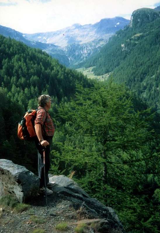
*** All the pictures of this page are by Antonio Giani, Marco Cossard "Crevassino", Emilio Bertona aka emilius, "Gigi" Gadin, livioz, marco87, Zed & Osw
*** Tutte le foto di questa pagina sono di Antonio Giani, Marco Cossard "Crevassino", Emilio Bertona alias emilius, "Gigi" Gadin, livioz, marco87, Zed & Osw

- From Turin or Milan: Motorway A5. Exit in Aosta Ovest. Drive to the near Aymavilles; follow in the direction of Cogne Valley. Or Exit Aosta East to Gr. Brissogne and St. Marcel.
- From Switzerland: through the Grand St. Bernard Tunnel or the homonym Pass). Drive to Aosta, then follow Courmayeur direction on SS.26. Just after Sarre, turn to the left, in the direction of Cogne Valley, the main side valley in the South after the City of Aosta.
- From France: through Mont Blanc Tunnel or Petit St. Bernard Pass). It isn't necessary to enter in Motorway A5, you can drive through SS.26 Aosta direction. Before arriving at the Village of Sarre, follow the sign and turn right towards the Valley of Cogne.
Specific Roads by Cogne Fénis & St. Marcel After Aymavilles Municipality, the RR.47 crosses the Villages of Vieyes (1.158m; ancient small Sainct Grat Church with various frescoes), Epinel (1.436m) and Crétaz (1.534m) and after about 25 Km. arrives at Cogne (1.534m; important Seat of P.N.G.P. since 1922). Follow the road signs for Gimillan and Lillaz (renowned three waterfalls); arrived at a round-about, recently built in proximity of the St. Anthony Chapel, go left along the scenic route leading to the Villages of Montroz (1.702m), Gimillan (1.787m); 1,5 and 3 Km. after Cogne. Usually no parking problem neeighbor the bell tower of a little chapel in center, also near the bridge above Gimillan Torrent (small parking).

From Fénis (537m) on Pieiller small Vallon towards Le-Pieiller-de-Sermaz, Maison Longue, Le Plany Hamlets (1.075m, 1.112m, 1.174m); through asphalt road) and subsequent connection with La Morgetta(z), Pressunettaz, alternative before Champremier (1.383m) at Les Druges Lower (1.567m) and Upper or "Les Druges Alte" small Villages (1.600m). From Saint Marcel (630m) towards the Saint Marcel Vallon and Turati Reserve up to the Mulac-St. Louis & Grande Chaux Hunting Houses and Alp (1.937m, 2.370m).
BY PLANE:
- Aeroporto "Corrado Gex" Saint Christophe (Aosta).

Route Description by Gimillan (Cogne) towards Les Druges (St. Marcel)
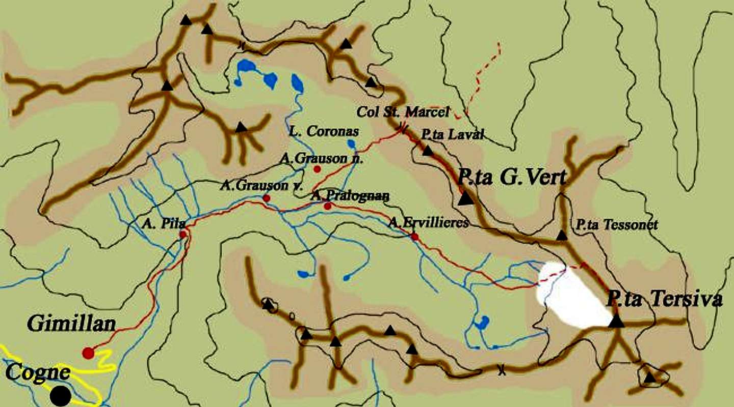
A) - In ascent from Gimillan Hamlet (1.787m) in Cogne Valley: go right starting from the car park 1.800 meters about of Gimillan: after few metres the indications to Lakes of Lussert, St. Marcel Hill are found. The pathway is indicated by the yellow circle 8/8A/8B/TVC and by yellow strips marked on stones along the route. The path begins going immediately uphill, then the slope decreases as we go beyond Révènti Alp (1.906m; perimeter ruines) and a little Chapel dedicated to the Virgin (1.836m). Soon the path resumes to go up and splits in two, before it begins to penetrate into the Grauson Vallon. It's possible to continue following the right one that goes down as far as the small bridge of Ecloseur Pastures (1.904m; shop-sign Tchezeu Alp; 1.918m), but in such a case we must go up again; it's better to follow the left one that, in practice without losing height, arrives at the bridge under the Alp of Pila (2.025m), cross it and, following the stepped pathway equipped with small wooded stairs, overcome the rocky bastion beside a fine waterfall (to the left). At this point the path turns right markedly, entering, high on the torrent, into a small vallon; by an alternation of steep and slight slopes, it reaches a panoramic cross, on the edge of a pleasant plateau. The path goes through the meadows, slightly descending and, after the Old Grauson’s Pastures (2.271m), crosses the Doreire Torrent on the small bridge and by a steep trail beside the torrent, reach the wide upper part of the Grauson Valley. At the junction before Pralognan Pasture (about 2.400m), instead of going straight ahead along the pathway 8/TVC leading to the head of Grauson/Doreire-Tessonet Vallon, go left (North) till to New Pasture (2.540m), where once there was the burned Tentori Bivouac, on Summer 2000. Before along grassy slopes and great blocks among small springs, after on a small rounded promontory with the path 8A/8B/102 towards the "Rane" (Frogs) Corona Lakes and by this last in short time in East to the St. Marcel Hill or Corona's (2.641m, 2.702m, 2.931m; 3h'30/4h'00).
A) - In salita dalla Frazione di Gimillan (1.787 m) in Val di Cogne: partire dal parcheggio (1.800 metri circa) trovando dopo pochi metri i "panneaux" con l'indicazioni per i Laghi di Lussert, il Colle di Saint Marcel o Corona, scegliendo quello giallo cerchiato in nero con l'indicazione 8/8A/8B/TVC. Il sentiero inizia salendo immediatamente in ripida salita per poi diminuire gradualmente in pendenza andando verso l'Alpe Révèntì (1.906 m; rovine perimetrali) ed incontrando subito dopo una Cappelletta dedicata alla Vergine (1.836 m). Subito dopo lo stesso riprende a salire con falsopiano e dividendosi in due presso un grosso cartello indicatore con piccola tettoia. Tenendosi sulla destra (Est) penetrare nel Vallone del Grauson e, tramite una breve discesa, raggiungere il Ponte dell'Ecloseur (1.904 m; cartello indicante l'Alpe Tchezeu; 1.918 m). Attraversarlo sul Torrente Lussert e, lasciate le Alpi Ecloseur appena a destra, con un lungo diagonale a sinistra ed in mezzo ai prati raggiungere il successivo Alpeggio di Pila (2.025 m), con alla sua sinistra una bella cascata. Superare la soprastante bastionata rocciosa doppiandola a sinistra con una gradinata attrezzata in legno con puntelli in ferro per poi ritornare a destra passando alti sul torrente in una valletta. Con pendenze alternate e lievi raggiungere una croce su d'un promontorio panoramico. Il sentiero attraversa la prateria in minima discesa e, dopo Grauson Vecchie o Dessous (2.271 m), guada sul ponticello il Torrente Doreire e con un ripido percorso accanto al medesimo perviene alla parte larga e superiore del Vallone del Grauson. Verso la congiunzione prima dell'Alpe di Pralognan (2.400 m), invece di progredire direttamente lungo il sentiero 8/TVC, che abbandona la testata del Vallone di Grauson/Doreire verso l'Invergneux, girare a sinistra (Nord) sino all'Alpe di Grauson Nuove o Dessus (2.540 m), ove esisteva il Bivacco Tentori andato a fuoco nell'estate del 2000. Attraversando pendii erbosi tra grandi blocchi e sorgentelle, dopo un piccolo promontorio arrotondato, pervenire su tranquillo sentiero 8A/8B/102 dapprima ai Laghi delle "Rane" e poi Corona e da quest'ultimo in breve tempo e verso Oriente al Colle di St. Marcel o di Corona (2.641 m, 2.702 m, 2.931 m; 3h '30/4h '00).
B) - In ascent by St. Marcel towards the homonym valley, Grande Chaux and Corona's Hill: from the rotunda to the entry of the St. Marcel Commune, to go up over on a wide bridge the Dora Baltea, bringing himself in the center of the same in direction of his great Church; to edge it and to continue (manifold indications for which thing, with the purpose not to be wrong, to follow the poster of brown color with the wording Plout Sanctuary. To go up again toward South with the Regional Road towards the Hamlets Crétaz (653m) and then, decidedly towards East, Jayer (693m) and Mezein (793m); immediately after this point, leaving on the left a ramification that goes down to the Municipality of Fénis (prohibition of transit for the cars), the road changes completely direction toward Southwest to reach the Village of Réan (898m) and, through a long diagonal, the famous Sanctuary of Plout (898m; * splendid "Via Crucis" in the covered communication trench and before), where from centuries a procession happens departing really from St. Marcel. Doubling it same the road is again addressed to thin East to a wide hairpin-road, where it reenters towards the preceding direction reaching the Village of Seissogne (1.066m) and, through great grasslands, the following one of Sazailland (1.220m); they follow those of Ronc (1.359m), Viplana (1.346m), Champremier (1.383m), over which he leaves on the left a deviation for the tall alpis of the Municipality Fénis (passable and open to the traffic) to reach the fork for Porteron (famous for his international footstep of the sled) and the following place of Leycher (1.506m; famous "Inn of the Devil"). Returning to East, the road leaves in low the short deviation for Lower Les Druges (1.567m) to reach later immediately to Upper Les Druges (1.600m about; beautiful fountain near a small square wooden "rascard" and just nearby votive small Chapel dedicated to St. Bernard, at the beginning of the path n° 14 to Fontanafreida Alp (1.810m), which is connected with the farm dirt road to the Alpe Bren (1.961m) at the feet of Mont Corquet. By Les Druges towards Grande Chaux: abandoning this deviation, from Les Druges "Alte", Pouria Pasture (1.600m; various panels) starting from the small lay-by beyond the rocky-wooden dump of the above abandoned Coppermines Chuc-Servette, and after rounding the cape entering the real vallon, walk "suspended" on the left (East) along the entire Vallon St. Marcel and, after passing a small gate, border of the Reserve by Marquis Turati ex Baron Peckoz, and after a short descent, remount passing through Mulàc Hunting House (1.937m; beautiful fountain with wooden steinbock) boarding on the right (Northwest) the manganese old Mine of Praz Bornaz also Prabor(g)na (1.882m; abandoned for years now). Cross the torrent on a footstep (1.995m) and walk up (little steeper with a final ramp to the East) get two Plan Ruè Pastures (2.100m) and, just after, to those Plan d'Emonin Dessous e Dessus Dessous e Dessus (2.129m, 2.219m). Once in Layet (2.233m; fine pond), flanked by a boulder, and in a short time, just after leaving the left (Southeast) deviation for Pastures of Petite Chaux (2.419m), you get the hunting House "Turati", ex Hunting House Baron Beck Peckoz Gressoney (2.370m), placed at the base of the Grand Vallon and Vallon Fenêtre. From Grand Chaux, leave on the Western side the route of the small vallon or Petit Vallon for the Leppe Pass and more to West-southwest the one of the big vallon also Grand Vallon (leading to the Vallonet Pass (3.062m) along tracks, more straight but steep and tiring). Once at the fork 2.602 metres; in opposite the other path goes to Lavodilec Hill (2.863m). Besides move more and more to the right, first with a Southerly direction and then the Southwest, crossing along a diagonal ascent on the morainic slopes of hanging Vallon Fenêtre you get the Saint Marcel also Corona Hill (2.931m through the base trail 4/102; abundant presence of soapstone) and from here follow the route 8B/102 coming by Gimillan Hamlet (E/F 1h'45/2h'15 from Grande Chaux Hunting House; 5h'30/6h'00 by Les Druges Village)
 |
 |
 |
 |
 |
 |
 |
 |
 |
 |
.![]()
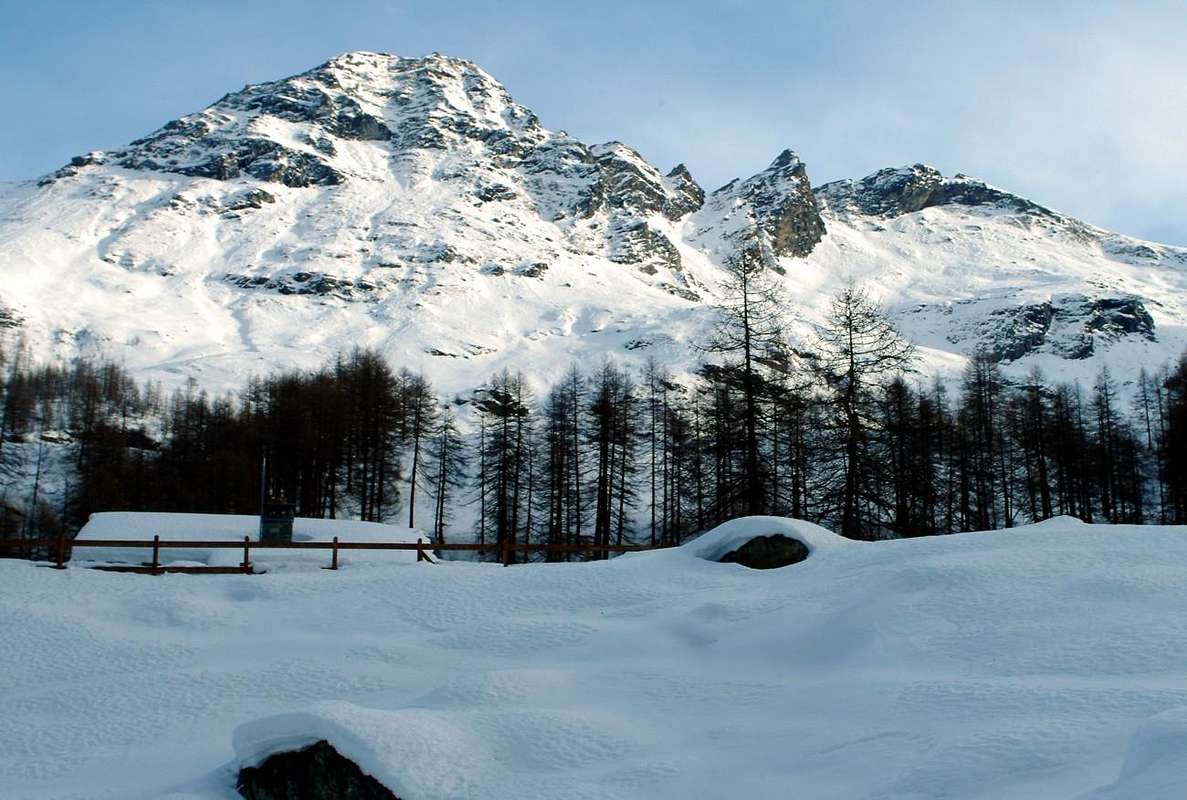
Winter near Praborna Manganesemine
B)- In salita verso Les Druges "Alte": dalla rotonda all'ingresso di St. Marcel, scavalcare su d'un largo ponte la Dora, portandosi nel centro dello stesso in direzione della sua grande Chiesa; contornarla e proseguire (molteplici indicazioni per la quale cosa, al fine di non sbagliare, seguire i cartelli di colore marrone con la dicitura Santuario di Plout. Risalire verso Sud con la Regionale verso le Frazioni di Crétaz (653 m) e poi, decisamente verso Est, di Jayer (693 m) e Mezein (793 m); subito dopo questo punto, lasciando sulla sinistra una diramazione che scende al Paese di Fénis (divieto di transito per gli automezzi), la strada cambia completamente direzione verso Sudovest per raggiungere il Villaggio di Réan (898 m) e, tramite un lungo diagonale, il celebre Santuario di Plout (898 m; * splendida Via Crucis nel camminatoio ricoperto ed antistante), dove da secoli avviene una processione partendo proprio da St. Marcel. Doppiando lo stesso la strada si indirizza nuovamente ad Est fino ad un largo tornante, dove rientra verso la precedente direzione raggiungendo il Villaggio di Seissogne (1.066 m) ed, attraverso grandi praterie, il successivo di Sazailland (1.220 m); seguono quelli di Ronc (1.359 m), Viplana (1.346 m), Champremier (1.383 m), oltre il quale si lascia sulla sinistra una deviazione per le alte alpi del Comune di Fénis (transitabile ed aperta al traffico) per raggiungere il bivio per Porteron (famosa per la sua pista internazionale dello slittino) e la successiva località di Leycher (1.506 m; rinomata "Locanda del Diavolo"). Ritornando ad Est, la strada lascia in basso la corta deviazione per Les Druges Basse (1.567 m) per pervenire subito dopo a Les Druges Alte (1.600 m circa; bella fontana presso un piccolo squadrato "rascard" in legno e Cappelletta votiva dedicata a San Bernardo, all'inizio del sentiero n° 14 per l'Alpe Fontanafreida (1.810 m), congiungentesi con la poderale verso l'Alpe di Bren (1.961 m).
Da Les Druges a Grande Chaux: partendo da Les Druges "Alte", località Pouria (1.600 m; cartelli varii), a partire dalla piccola piazzola al di là della discarica dell'abbandonata miniera di rame Chuc-Servette, e dopo aver doppiato il promontorio roccioso-boschivo entrando nel vero e proprio vallone, camminare "sospesi" sulla sinistra (Est) lungo l'intera Valle di Saint Marcel e, dopo aver superato un cancelletto, confine della Riserva di proprietà del Marchese Turati ex Barone Peckoz, e dopo una breve discesa, rimontare passando affianco alla Casa di Caccia di Mulàc (1.937 m; bella fontana con stambecco in legno), con immediatamente sulla destra (Nordovest) l'antica miniera di manganese, abbandonata ormai da molti anni, di Praz Bornaz o Praborna od ancora Praborgna (1.882 m). Si attraversa il torrente su d'una passerella (1.995 m) e, tramite percorso appena più ripido con rampa finale ad Est, arrivare alle due Alpi di Plan Rué (2.100 m) ed immediatamente dopo a quelle del Plan d'Emonin Dessous e Dessus Dessous e Dessus (2.129 m, 2.219 m). Dopodiché raggiungere l'Alpe di Layet (2.233 m) nei pressi d'un grazioso laghetto, fiancheggiato da un masso, ed in breve tempo, subito dopo aver lasciato sulla sinistra (Sudest) la deviazione per gli Alpeggi di Petite Chaux (2.419 m), pervenire alla Casa di Caccia "Turati", una volta Casa Barone Beck Peckoz di Gressoney, (2.370 m), collocata alla base del Gran Vallon e del Vallon Fenêtre. Da Grand Chaux, lasciare ad Occidente la via adducente al valloncello per il Colle di Leppe o Petit Vallon ed invece prendere più a Ovest-sudovest quella della Grand Vallon che conduce al Colle di Vallonet (3.062 m) tramite un sentierucolo seguito da tracce con percorso più diretto ma ripido e faticoso ad Ovest partendo dal bivio sottostante (2.602 metri; in direzione opposta l'altro s'indirizza al Colle di Lavodilec). Altrimenti dirigendosi invece ancora maggiormente a destra, prima con direzione Sud quindi Sudovest, attraverso un lungo diagonale tra pendii morenici nel cosiddetto e superiore Vallon Fenêtre, si perviene al Colle di Saint Marcel o Coronas (2.931 m; pietra "ollare") tramite il sentiero di base 4/102. Indii riprendere il percorso 8B/102 da Gimillan (E/F; 1h'45/2h'15 dalla Casa di Caccia Grande Chaux; 5h'30/6h'00 da Les Druges).
 |
 |
 |
 |
 |
Essential Gear
Equipment: for Hiking.Equipaggiamento: da Escursionismo![]()
Difficoltà: per E od Escursionisti
Campings
Remember that free camping is forbidden (except for emergency reasons, over 2.500m, from darkness until dawn).Mountain Condition
- Meteo: you can find all the needed informations at the official site of the Valle d'Aosta Region:
- Valle d'Aosta Meteo
Important Information
- REGIONE AUTONOMA VALLE D'AOSTA the official site.
- FONDAZIONE MONTAGNA SICURA Villa Cameron, località Villard de la Palud n° 1 Courmayeur (AO) Tel: 39 0165 897602 - Fax: 39 0165 897647.
- A.I.NE.VA. (Associazione Interregionale Neve e Valanghe).
Useful numbers
- Protezione Civile Valdostana località Aeroporto n° 7/A Saint Christophe (Ao) Tel. 0165-238222.
- Bollettino Meteo (weather info) Tel. 0165-44113.
- Unità Operativa di Soccorso Sanitario Tel. 118.