
-
 32364 Hits
-
 81.18% Score
-
 13 Votes
|
|
Mountain/Rock |
|---|---|
|
|
41.572°S / 148.23700°E |
|
|
Hiking, Scrambling |
|
|
Spring, Summer, Fall, Winter |
|
|
2241 ft / 683 m |
|
|
Overview
 |
St Patrick’s Head Pinnacle is located in the Tasmanian State Reserve of the same name at the east end of the lovely Fingal Valley, close to the village of St Mary’s. Few tourists come this way, so add this one to your list if you’re an afficionado of the obscure and want to get away from the increasing numbers of people travelling to Tassie these days. Great coastal views from the summit and a vigorous short climb combine to make St Patrick’s an undiscovered little gem.
My camera was on the frits when I did this, so I’m afraid I don’t have many photos to add, nor is what I do have of very good quality. Let’s hope that others make their way over to the east coast and add more shots, particularly of the scramble up the last bit. I did, however, dig up this interesting historic photo
Getting There
I’m not aware of public transport options, so the following assumes you have a car available.
Approach on the A1, the main road running from Devonport to Hobart. Near the village of Conara take the main access road to the east coast, the A4, down the Fingal Valley ~75km to St Mary’s. Drive through the village and just before entering St Marys Pass there is a signed right turn for St Patrick’s Head. The road becomes gravel after 1km. Go ~3km almost to the end of the road to where it turns sharp left uphill and becomes more of a lane. Don’t drive up the lane. Park your car here. Facing you and to the right of the lane is a barn with big lettering on the side advising you to “beware of the bull”.
Approach and route
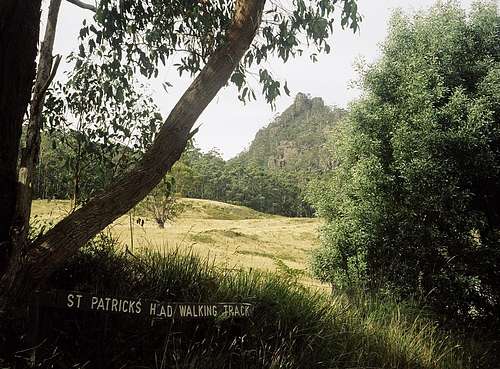
Walk up to the end of the lane where there is a gate set in the wall and a sign announcing the track. This is not the official track start however. Go through the gate, up the path and skirt the left edge of the field (hopefully when the bull is asleep) to where you can see the official sign above you.

The north coast

Fingal Valley
From the track start the obvious path climbs very gently at first through the forest under the west side of the Pinnacle. After 10-15 minutes you’ve traversed to the south side of the peak and the track turns left and heads up abruptly and steeply. The way is now loose, slippery and eroded and stays this way until you’ve cleared the trees and are directly under the rock tower of the Pinnacle itself. The route now spirals around to the east side of the summit and becomes a marked route as the last of the path disappears. Follow the coloured blazes up and between several sub peaks to eventually emerge on the summit with its large trig. There is some considerable exposure in the final 5 minutes to the top and steep drop-offs on all sides once there. While not exactly a via ferrata, there are several steel ladders and hand lines in place to assist the climber.
Below you to the east from Bicheno in the south to St Helens in the north are the huge Tasman Sea breakers crashing ashore. To the west, the pastoral tranquility of your approach, the Fingal Valley, with the huge bulk of the Ben Lomond plateau behind. Even further west are the layers of the Great Western Tiers.
Descend by reversing the above being extra careful on the steep, eroded sections
The total distance is approximately 5km with an elevation difference of ~400m. Round trip time from the car is no more than 2-2.5hrs with the descent taking a little longer than the ascent.
Red Tape
None. However, there is an intentions book at the trailhead information booth that you’re encouraged to use.
Camping
Not applicable
Cautionary note
Poisonous snakes are a fact of life in Tasmania or anywhere else in Australia for that matter. Whereas you should be alert to possible harm from snake bite, it shouldn't put you off getting "out there" into the Aussie bush. Incidences of fatal snake bite are about as rare as those of cougar attacks in North America. They happen - but does that stop you going? Nevertheless be aware of the possibility and do what the locals do. Wear long pants and/or gaiters. You will even see road crews wearing ankle gaiters while clearing bush next to Aussie thoroughfares. Most poisonous snakes in Australia have short fangs and this precaution usually suffices. A local told me that some snakes make a barking noise on the approach of a threat by inflating themselves and expelling the air rapidly and, I must say, I often heard what I thought was a stray dog in a few unusual places in Tasmania. However, knowing Aussie humour, this could be entirely apocryphal.
External Links
Any map you may need for Tasmania can be obtained at TasMaps
Tasmanian East Coast State Reserves