Toggle navigation
Mountains
Routes
Images
Trip Reports
Forum
What's New
People
Areas & Ranges
Articles
Trailheads
Canyons
Huts & Campgrounds
Albums
Logistical Centers
Fact Sheets
Lists
Custom Objects
Gear
Plans & Partners
WELCOME TO SUMMITPOST
SIGN IN
REGISTER
Little Water Peak
Additional Parents
Image
Little Water Pk & Reynolds...
View High-Resolution Image
Little Water Pk & Reynolds...
Little Water Pk & Reynolds Pk Overview Map
Trail
,
Class 1
A
-
Right Branch of Butler Fork
B
-
Mill D North Fork Trail
C
- Beartrap Fork Trail
D
- Desolation Trail
E
- Upper Millcreek Trail - South Fork
F
- Upper Millcreek Canyon Trail - North Fork
G
- Little Water Gulch Trail
H
-
Official Big Water Trail
I
- Wasatch Crest Trail
J
-
Millcreek Ridge
K
-
West Ridge - Little Water Pk
L
-
North Ridge - Reynolds Pk
Information is a combination of personal experience, USGS topos, and route descriptions on SP. Please let me know if any additions or corrections are needed in the map or labeling.
« PREV
NEXT »
PellucidWombat
on
Jul 18, 2005 2:58 pm
Comments & voting
Other parents
Lat/Lon:
40.67190°N / 111.6277°W
Image ID:
115322
3159 Hits
72.08
% Score
2
Votes
Log in to vote
Comments
No comments posted yet.
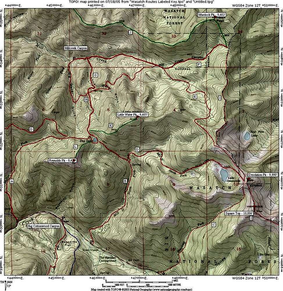
to post!
Don't have an account?
Little Water Peak
(Mountain/Rock)
« PREV
Viewing
#26 of 29
GALLERY
NEXT »
PellucidWombat's Image Gallery
« PREV
Viewing
#1658 of 2324
GALLERY
NEXT »
×
You need to login in order to vote!
User Name
Password
Remember me
Forgot your password?
Log me out when I close my browser.
Keep me logged in all the time.
sign in as a user
Don't have an account?
Register now for FREE
Rating available
Suggested routes for you
People who climb the same things as you
Comments Available
Create Albums
Register Here