
-
 8139 Hits
-
 83.1% Score
-
 16 Votes
|
|
Mountain/Rock |
|---|---|
|
|
40.86580°N / 110.5012°W |
|
|
Summit |
|
|
Hiking |
|
|
Summer, Fall |
|
|
11776 ft / 3589 m |
|
|
Overview
The beauty of the High Uintahs unfolds before the hiker's eyes.
28 Jul 2007
Bald Mountain B resides on the north slope of the High Uinta Mountains, the “Roof of Utah”. Not limited to lofty peaks, the High Uintas in northeastern Utah are home to more than 500 lakes, many unnamed. This area contains the lovely, 456,705-acre High Uintas Wilderness.
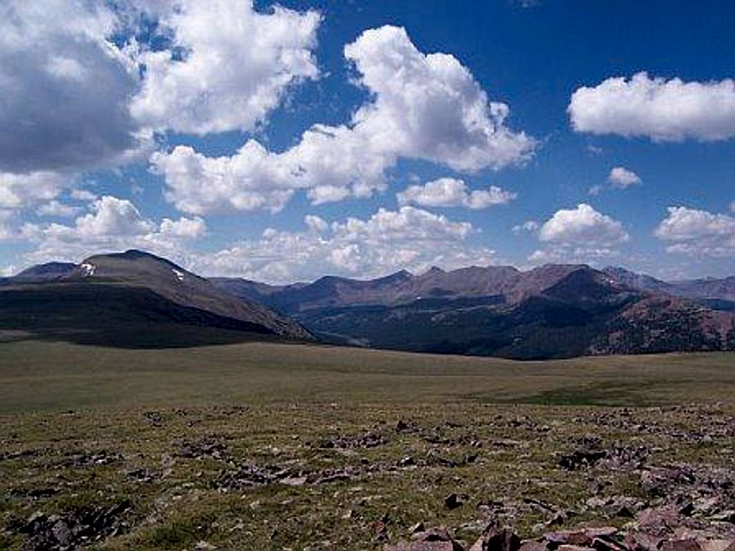
From the summit of Bald Mountain B, the hiker enjoys dramatic, panoramic views of the High Uintas, in all directions. Looking several hundred feet down to the east-northeast, one can gaze down upon Bald Lake.
Not to be confused with it’s higher Uinta neighbor of the same name Bald Mountain - 11,947 ft, Bald Mountain B is easily accessed from the high point of the Bald Mountain Trail from the East Forks Blacks Fork Trailhead. This Bald Mountain Trail is, in turn, not to be confused with the Bald Mountain Trail that whisks hikers to the summit of the higher of the Uinta Bald Mountains.
Utah Rank: 103rd highest mountain in Utah
Utah 11ers Rank: 13th highest 11er in Utah
Prominence: 356 feet
USGS Quad: Mount Lovenia
Rank and prominence information: Lists of John
Getting There
Directions to the East Fork Blacks Fork TrailheadFrom the traffic light in Kamas and the intersection of route 248 and 32, head north 0.1 to SR 150 (Mirror Lake Highway). Turn Right onto SR 150 and follow for 49 miles to FR 058, turn right onto FR 058 (Dirt Road) and follow for 21.2 miles to the intersection with another dirt road heading north south. Turn right and follow road south for approximately 6 miles to the parking area at the East Fork Blacks Fork camping area and trailhead.
As of July, 2014, the last six miles or so of road into the trail head were pretty rough. We made it in a mid-size sedan, but bottomed out once or twice and wound up getting a flat tire due to a pointy rock. Suggest a SUV with good tire tread is most appropriate to reach the trail head at this point in time. - SP Member Bark Eater
Driving directions borrowed from
East Fork Blacks Fork
![Bald Lake from Bald Mountain Trail]()
The lovely, lonely Bald Lake from just under the summit of Bald Mountain B. Looking east-northeast. 28 Jul 2007![Views from Bald Mountain B Summit_C]()
Mountains as far as the eye can see, northeastern Utah. From the summit of Bald Mountain B. 28 Jul 2007 ![Views from Bald Mountain B Summit_D]()
The magic of the High Uintas from the summit of Bald Mountain B, northeastern Utah. 28 Jul 2007
Walk softly and follow LNT (Leave No Trace) principals.
Be aware that the High Uintas are heavily used by sheep herders. Dogs need to be leashed in wilderness areas to begin with. However, should your dog be unrestrained and sheep are encountered, leash your dog at once. It is the responsibility of the herder to protect his sheep from threats, such as coyotes, pumas or domestic dogs, and he will do so, even employing means lethal to your best friend. Should the herdman have herding dogs with him to protect his flock, the outcome could quickly become even more gruesome.
US Forest Service Map (PDF): High Uintas - West Half

Driving directions borrowed from
East Fork Blacks Fork
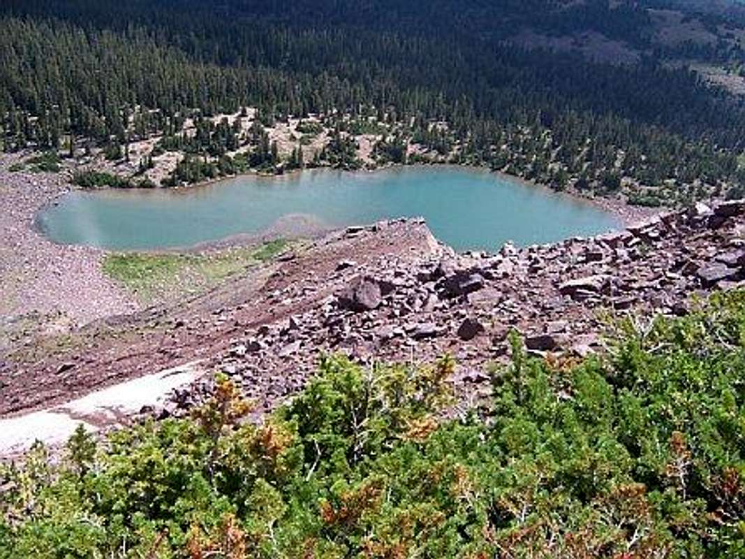
The lovely, lonely Bald Lake from just under the summit of Bald Mountain B. Looking east-northeast. 28 Jul 2007
Red Tape

Mountains as far as the eye can see, northeastern Utah. From the summit of Bald Mountain B. 28 Jul 2007

The magic of the High Uintas from the summit of Bald Mountain B, northeastern Utah. 28 Jul 2007
Walk softly and follow LNT (Leave No Trace) principals.
Be aware that the High Uintas are heavily used by sheep herders. Dogs need to be leashed in wilderness areas to begin with. However, should your dog be unrestrained and sheep are encountered, leash your dog at once. It is the responsibility of the herder to protect his sheep from threats, such as coyotes, pumas or domestic dogs, and he will do so, even employing means lethal to your best friend. Should the herdman have herding dogs with him to protect his flock, the outcome could quickly become even more gruesome.
Camping & Lodging
- Rustic car camping is available at the East Fork Blacks Fork campground at the trailhead.
- Comfortable, reasonably-priced hotels are available in nearby Evanston, Wyoming.
External Links
Visit the Evanston Ranger District, Wasatch-Cache National Forest online or call (801) 642-6662.US Forest Service Map (PDF): High Uintas - West Half
Bark Eater - Jul 14, 2014 11:06 am - Voted 10/10
Rough RoadAs of July, 2014, the last six miles or so of road into the trail head were pretty rough. We made it in a mid-size sedan, but bottomed out once or twice and wound up getting a flat tire due to a pointy rock. Suggest a SUV with good tire tread is most appropriate to reach the trail head at this point in time.
Sarah Simon - Jul 14, 2014 9:16 pm - Hasn't voted
Re: Rough RoadThank you for this update and corrected information. I will update the page accordingly! Climb safely this summer! Sarah
Bark Eater - Jul 16, 2014 7:01 am - Voted 10/10
Re: Rough RoadThanks, Sarah. Hope you get out on a Colorado adventure with Hotoven soon. Great guy!
joshuadyal - Oct 16, 2014 3:41 pm - Hasn't voted
Re: Rough RoadI didn't have any problem in a small sedan in August 2014.
Bark Eater - Nov 17, 2014 3:51 pm - Voted 10/10
Re: Rough RoadThat's good. Apparently the FS must have gotten in and graded it between early July and August. Hope you had a fun trip!
gooncaptain642 - Apr 29, 2016 12:12 am - Hasn't voted
MilesHow many miles is this trip? And about how long do you think it would take to hike this?
Sarah Simon - May 3, 2016 4:08 pm - Hasn't voted
Re: MilesActual distance to reach the summit of this mountain, like any other, depends upon your approach. To begin, you may wish to check the black Black Forks route which I posted attached to this mountain page. Please see left-hand bar on this main mtn page.