
|
|
Area/Range |
|---|---|
|
|
42.20411°N / 13.46924°E |
|
|
Hiking, Mountaineering, Ice Climbing, Mixed, Scrambling, Canyoneering, Skiing |
|
|
Spring, Summer, Fall, Winter |
|
|
8156 ft / 2486 m |
|
|
Introduction
 |
|---|
Velino and Sirente are two ranges usually matched in the guidebooks and, since 1989, both parts of the Velino-Sirente Natural Park. Different mountains, but sharing many characteristics: they haven’t the big rock walls of Gran Sasso, the huge canyons of Majella, but we can find in this area many places where nature is still intact: the wide beech woods, the lonely ridges and peaks, the isolated valleys are places where you can easily see the flight of eagles and vultures and wolves roam since immemorial times...
These mountains are more visited in summer, but in every season there are many interesting reasons to climb: in winter, when the snow covers roads and trails, and these mountains are approchable only by long walks on the snow or with skis (maybe, it’s the better season to visit this area); in fall, when the colors of woods and the beautiful light are a great spectacle; in spring when the pastures in bloom contrast with the snow still remaining over the summits and in the couloirs...
The activities you can enjoy in Velino-Sirente group are a lot: hiking and trekking most, but also mountaineering ascents, especially in winter. In the cold season these mountains become a great playground for ski-tourers: there are many routes for alpine touring skiers but also for backcountry nordic skiers, that in the highplains and roundshaped mountains of the area find an ideal playground.
So, there are several good reasons to enjoy these mountains: with the following description I’ll try to make you known.
Geographical overview
Velino-Sirente area is mainly placed in western Abruzzo, in central Italy, with a very little part, in the west, situated in Lazio. This area has a very complicated orography: unlike other ranges of Central Apennines (Gran Sasso, Majella, Laga, Sibillini), arranged in an unique main chain, the Velino-Sirente mountain area is composed by many ranges, separated by deep valleys and plateaus. First of all, we can distinguish the two main groups: Velino group and Sirente group. Sirente group has a simple conformation and we can split it in two parts: Monte Sirente and Monte Tino (better known as Serra di Celano), separated by the Gole di Celano canyon. Velino group is more complicated: it’s composed by a vast system of mountains arranged in several chains intersecting each other. That conformation involves that we can branch Velino group in various subgroups, which borders are hardly identifiable. The main subgroup, where are placed the higest summits, is Velino and Cafornia Massif; at the east of it, it’s placed the Monti della Magnola subgroup; at the north, the Monti di Campo Felice subgroup; at the north-west, across the boarder between Abruzzo and Lazio regions, the Monti della Duchessa subgroup.Velino group and Sirente group are separated by the wide valley of Altopiano delle Rocche, where are placed many towns.
Velino and Cafornia Massif
 |
|---|
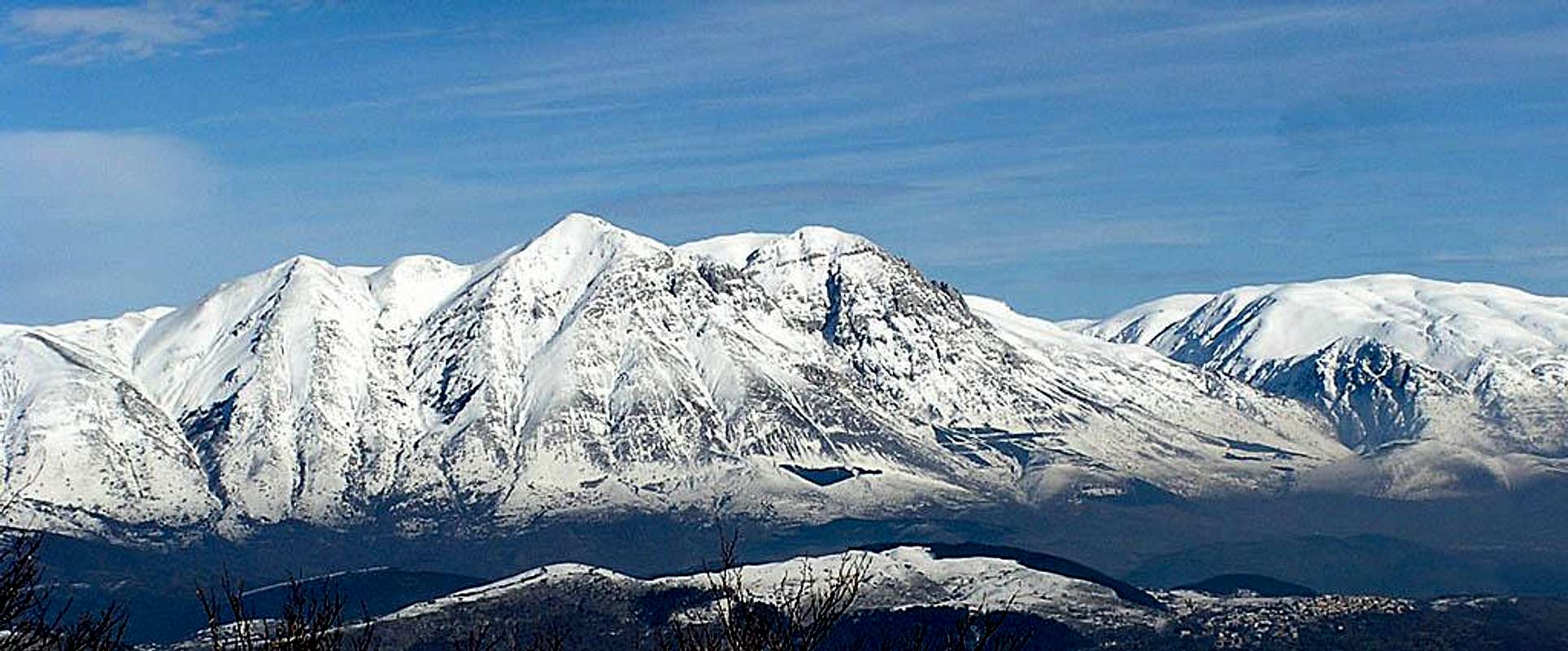
The highest summits of the whole area are situated in the Velino and Cafornia Massif. This subgroup is delimited on the south by the Fucino plain, on the north by the Teve Valley, which splits it from Monti della Duchessa subgroup, on the east and north-east by Majelama/Bicchero Valley, which separates it from the Monti della Magnola subgroup. The main summit is Monte Velino (2487m): it rises with a prominence of more than 1700m above the Fucino plain and is visible by very far distance, especially from west: in fact, it’s the highest summit visible from the downtown of Rome.
At east of Monte Velino is placed Pizzo Cafornia (2424m), the “twin mount” of Monte Velino: it’s separated from Monte Velino by the steep couloir Canalino.
At west of Monte Velino is placed Monte di Sèvice (2331m), then the ridge continues with Monte Rozza (2064m) and ends at Bocca di Teve, near the small town of Càrtore.
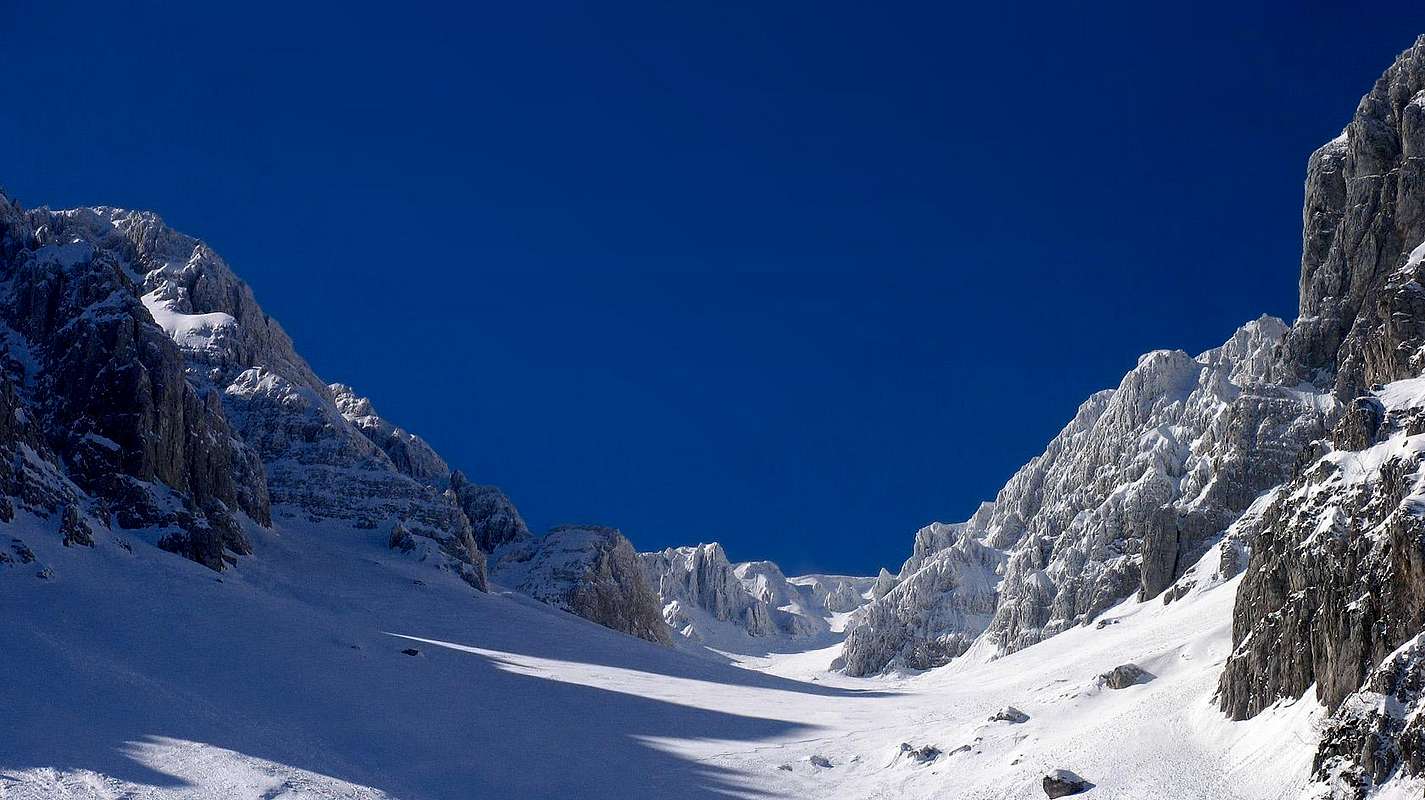
Toward north Monte Velino and Pizzo Cafornia are separated from Monte Il Bicchero (2161m) by the Vallone dei Briganti bowl, a beautiful glacial cirque placed at south of Teve Valley head (Capo di Teve).
Magnola
 Monte della Magnola
At east of the Velino and Cafornia Massif, separated from it by the deep Majelama Valley, is situated the Magnola subgroup. This subgroup is formed by the Monti della Magnola chain in the south, and by the Costone della Cerasa and Capo di Pezza chains in the north.
The Monti della Magnola chain, a beautiful group of mounts, disfigured by some chairlifts on the eastern side, culminates with a summit of 2220m: at north-east this chain goes down with short and steep rocky spurs, towards the town of Ovindoli and the Altipiano delle Rocche valley; at south-west, it has less steep and uniform slopes declining toward the small town of Forme. Monti della Magnola chain continues toward north with the little Costone della Cerasa range, that delimites on the south the beautiful plateau of Piani di Pezza. Then, continues with Capo di Pezza chain, and after the two beautiful summits of Punta Trento (2230m) and Punta Trieste (2242m), facing above Piani di Pezza, the chain ends at west at Colle dell’Orso pass (2202m).
Monti della Duchessa
 Monti della Duchessa
Monti della Duchessa subgroup is separated from the Velino and Cafornia Massif by Teve Valley.
This beautiful range of mountains, placed in the western part of Velino and Sirente range and being part, for the most, of the Lazio region, is composed by three important mountains: Murolungo, Monte Morrone, Torricella.
Murolungo (2104m) is the southernmost: it presents a wild and huge rock face, by wich takes its name (Muro-lungo, in italian, means “long wall”), that falls on the Teve Valley at south; this rock wall is wide and impressive, but not many attractive for climbers, because of the bad quality of its rock. On the north side, instead, Murolungo presents a less high face, dominating the Duchessa Lake bowl, that offers a better rock quality.
Duchessa Lake is a very characteristic lake, the only of Velino-Sirente range and the higher of the whole central Apennines, that lies in a beautiful bowl, surrounded by many summits more than 2000m high: a very suggestive and lonely place. This bowl is reachable by the little town of Càrtore by two valleys: Valle Fua (called in the higher part Valle del Cieco), a steep and narrow couloir covered by thick woods, and Valle di Cesa, a less steep valley, rised by a dirty road.
On the north of Duchessa bowl is placed Monte Morrone (2141m), a beautiful and lonely mountain, the highest of this subgroup. At the north east of it, there are the pastures, surrounded by woods, of Il Campitello bowl, dominated at south by the rocks of Uccettu Peak (2000m). Campitello bowl is linked to Duchessa Lake bowl by the Selletta della Solagna pass (1961m) and, toward north-west, to the town of Corvaro by the Asino Valley.
At the orographic left of the Asino Valley, at north-east of Monte Morrone, is placed Monte Ginepro (1934m), another relevant and good-looking mountain.
At the north-east, Campitello bowl is separated from Morretano valley by La Torricella (2071m): this is a long and scenic ridge, wiht west to east orientation, setting the border between Monti della Duchessa and Monti di Campo Felice subgroup.
At the east of Campitello bowl, the ridge joining Il Costone (2271m) with Monte Puzzillo (2174m) splits Monti della Duchessa subgroup from Puzzillo bowl and Monti di Campo Felice on the east.
 On the left, Murolungo; on the right, Morrone
Monti di Campo Felice
 Monte Costone
In the Monti di Campo Felice subgroup are included the northernmost summits of Velino-Sirente range. One of the most important summit is Monte Puzzillo (2174m), placed at north of Torricella and Morretano pass: it’s a nice looking mount, dominating the Puzzillo bowl and facing on Campo Felice plateau, well known by ski tourer because of the famous “Puzzillo ski-tour”. Monte Puzzillo continues toward north-west with the summit of Monte Cornacchia (2010m), ending on the Chiesola pass (1644m), that separates the Campo Felice plateau from Tornimparte. At north of Chiesola pass we found Monte Orsello (2049m) and, at the east of it, Monte Cefalone (2142m) a bare mountain rising over Campo Felice plateau. The range continues toward north with the summits of Monte Cagno (2159m) and Monte Ocre (2209m), two imposing mountains clearly visible from the city of L’Aquila.
At the north west, at the border with the Cicolano region, Monte San Rocco (1880m), Monte Cava (2000m) and Monte Rotondo (1993m) are the last north-western part of the whole Velino-Sirente range.
Sirente
|
|
|---|


Splitted from Velino range by the Altopiano delle Rocche valley, Sirente range has a simpler orography in comparison with its higher neighbour. We can indeed divide Sirente range in two: Monte Sirente Massif and Monte Tino, better known as Serra di Celano.
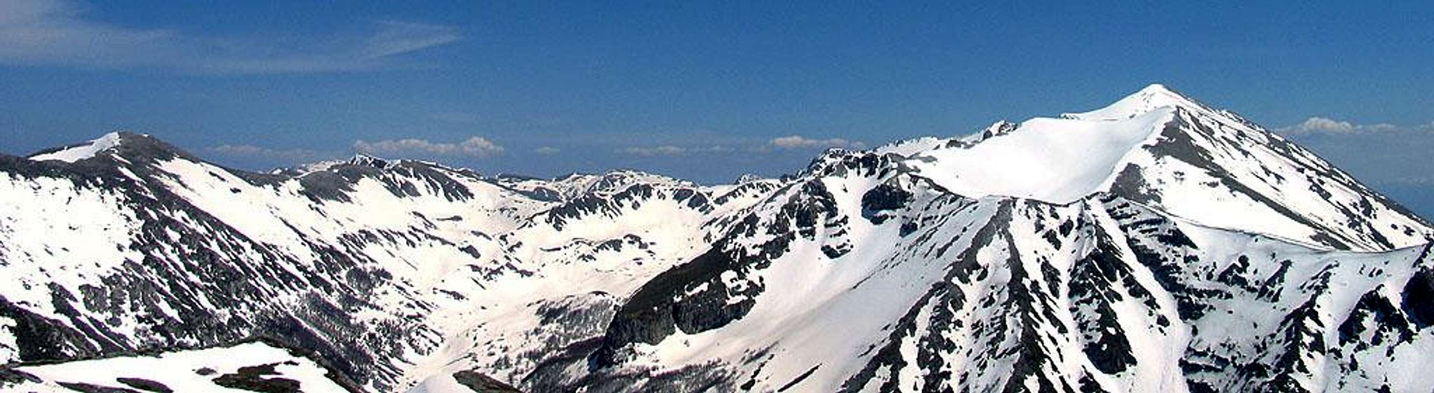
Monte Sirente Massif has two very dissimilar sides: the north side is a 2km long rock face, 500m high, with many rock spurs separated by several couloirs. Most of these couloirs, in winter, are interesting skitouring routes, like Canalone Majori and Valle Lupara, that lead to the main summit. The south side instead, is a vast carsic plain, molded by atmospheric agents, that gently goes down toward the little town of Ajelli. This two different sides (north and south) are bordered by a 15km long ridge, starting from the town of Rovere on the west and ending near the towns of Secinaro and Gagliano Aterno on east: along this ridge are placed the summits of the massif. The most relevant summits we can identify are (from the west to the east): Monte di Mandra Murata (1949m), Punta Macerola (2258m), Monte Sirente (2348m), Montagna di Canale (2207m), Monte San Nicola (2012m).
Serra di Celano is a not so high but beautiful looking mountain: is placed on the south of Monte Sirente Massif and is seperated from it by the Gole di Celano Canyon. This little mountain has its main summit (1924m) placed at south, overtopping the city of Celano: this summit presents a beautiful rocky ridge, running toward east; after a wide saddle, the ridge turns toward north (Serra dei Curti), constituting the southern rim of Arano Valley. On the west of Serra dei Curti, the Piano dei Curti plain comes to the town of Ovindoli, while on south-west the Valle dei Curti valley flows into the near of Celano. On the west of Piano dei Curti and Valle dei Curti, the low summits of Monte Faito (1704m) and Pizzo di Ovindoli (1504m) are the last reliefs of Serra di Celano subgroup.
 |
|---|
Summits over 2000m
|


Some naturalistic remarks
Geology
 Costone north face: bad limestone rock
The rocks of the Velino-Sirente area are constituted, for the most, by limestones and sporadic dolomites, formed by sediments deposited during the middle Jurassik age (about 160 millions of years ago) and the lower Cretaceous age (about 60 millions of years ago).
The actual looking of the landscapes is dued, for the most, to the events of the Quaternary age.
We can identify many signs of Quaternary glaciations over these mountains: especially in the north face of Monte Sirente, where the several couloirs coincide with small ancient glacier, and in Velino group, where Teve and Majelama valleys are typical “U” shaped glacier valleys.
In Velino group we found also several glacial cirques: above Valle dei Briganti; above Piani di Pezza, under the ridge joining Cimata di Pezza, Colle dell’Orso and Punta Trento; above Valle il Bicchero and Valle Majelama, under Punta Trento and il Bicchero; above the two sides of the ridge joining Monti della Magnola with Costone della Cerasa.
The vast plains surrounded by peaks, characterizing the actual landscape, like Piani di Pezza, Campo Felice, Altipiano delle Rocche, were formed by the alluvial deposits left by big lakes of the Quaternary age.
Also carsic phenomena are common in Velino-Sirente area: south side of Monte Sirente presents many doline and little valleys, due to the rain erosion of limestone sole; the Gole di Celano canyon, the Vaccamorta cave, near Tornimparte, and the Stiffe cave are other examples.
Fauna
 Italian Wolf (Canis Lupus Italicus)
Very interesting are also the bird species, with the presence of Griffon Vultures (Gyps Fulvus), easy to see flying above Monte Velino southern side, Golden Eagles (Aquila Chrysaetos), Peregrine Falcons (Falco Peregrinus), Alpine Choughs (Pyrrhocorax graculus).
Among reptiles, are present several species of snakes: worthy to be mentioned is the rare and few poisonous Orsini Viper (Vipera Ursinii), a small viper living, in Italy, only in the Central Apennines.
Flora
 An old beech
The flora of Velino-Sirente range is the typical one of central Apennines: wide beech (Fagus Sylvatica) forests at the medium-high altitudes (especially beautiful are the forest of the Sirente northern side and the one of Valle di Teve and Valle Morretano, in the north part of the range), mixed woods (diverse types of oaks, Ostrya carpinifolia and other essences) in the lower and sunny places.
In spring, many flowers blow everywhere: worthy to be mentioned is the Narcissus, to which is dedicated a festival every may, by the town of Rocca di Mezzo
Getting there
Due to the complex orography of the area, there are several accesses to Velino-Sirente range, depending what part of these ranges we want to reach. If you come from the western part of Italy, you have to reach Rome, while you have to reach Teramo or Pescara if you come from the eastern side. From these cities, you can reach the main acesses to Velino-Sirente area by car with A24/A25 highway.The main access are:
to Monti della Duchessa and Velino range western part, A24 highway until the stations of Valle del Salto (75Km from Rome, 91Km from Teramo);
A24 highway until the station of Tornimparte (92Km from Rome, 74Km from Teramo) to Campo Felice and Velino range northern part;
A24 highway until the station of L’Aquila ovest (108Km from Rome, 58Km from Teramo) to Monte Cagno, Monte Ocre and Velino range northern part.
A25 highway until the station of Magliano dei Marsi (75Km from Rome, 106Km from Pescara) to Velino massif south side;
A25 highway until the station of Celano (93Km from Rome, 88Km from Pescara) to Sirente range and Velino range western part.
By bus: you can reach Avezzano from Rome by bus service, then from Avezzano you can reach by bus Ovindoli.
Here the link to the Bus company ARPA
Campo Felice is linked to Rome by a bus service during the winter season.
The nearest international airports to the area are Rome Ciampino Airport, Rome Fiumicino Airport, Pescara Airport.
Accomodation
 In the town of Càrtore you can rent nice apartments. It's a good place for start Velino ascent
In the Velino-Sirente range there are two of the main ski resorts of central Apennines, so you can find a large offer of Hotels and B&B.
In the small town of Càrtore, in the Monti della Duchessa subgroup, you can rent small and very typical apartments, at a low price: they are a good starting point for hikes in the Monti della Duchessa mountains and for the ascent of Monte Velino too.
There is only a camping, in Magliano dei Marsi, above Monte Velino south side.
Some links:
- Hotels in Rocca di Mezzo
- Hotels in Rocca di Cambio
- Hotels in Ovindoli
- Hotels in Altipiano delle Rocche (Ovindoli, Rovere, Rocca di Mezzo, Rocca di Cambio)
Huts and Bivak
In the Velino-Sirente range huts and bivaks are few, and usually they aren't managed.
 |  |  |  |
| Name | Height | Owner | Open | Tel. |
|---|---|---|---|---|
| Rif. Sebastiani al Colletto di Pezza | 2102m | Cai Roma | June-September and on demand - winter room always opened | +39 339 1079741 (manager) +39 368 279463 |
| Rif. Capanna di Sèvice | 2119m | GEV | You can get keys at the Danilo Santoponte's tobacco-shop, in Magliano dei Marsi | +39 347 6873118 (manager: Achille Fontani) |
| Rif. Telespazio | 1979m | Cai Avezzano | - | +39 368 543319 (manager: Pietro Concia) |
| Rif. Gigi Panei | 2178m | - | Always opened, bad conditions | - |
| Rif. Le Caparnie | 1700m | Sant'Anatolia municipality | Always opened, no beds | +39 0746 30493 (Monti della Duchessa Natural Park) |
| Rif. Forestale Campitello | 1720m | Cfs | Always opened, bad conditions | - |
| Rif. La Vecchia | 1900m | - | Always opened | - |
Red tape
 Duchessa lake: one of the first places of the range to be protected by a Natural Park
Since 1989, Velino-Sirente range is part of Parco Naturale Regionale Velino Sirente. The northern part, in Lazio region, is protected too, by the Parco Naturale Regionale Monti della Duchessa.
In the protected area no fees are dued, no access permits are required, but free camping is not allowed (you need a special permit) and you have to respect the rules for environment protection in force in the Park. In particular, all users of the Park are asked to stay on marked trails to protect against erosion.
In the period 15 february-15 august is forbidden passing through Valle Majelama, to not disturb the eagles reproduction.
Passing through Val di Teve is forbidden in the period 01 october-30 may, because of landslide danger.
Alpine Rescue
 | C.N.S.A. ABRUZZO ALPINE RESCUE PHONE NR. 800-258239 |
 | GUARDIA DI FINANZA ALPINE RESCUE PHONE NR. 117 |
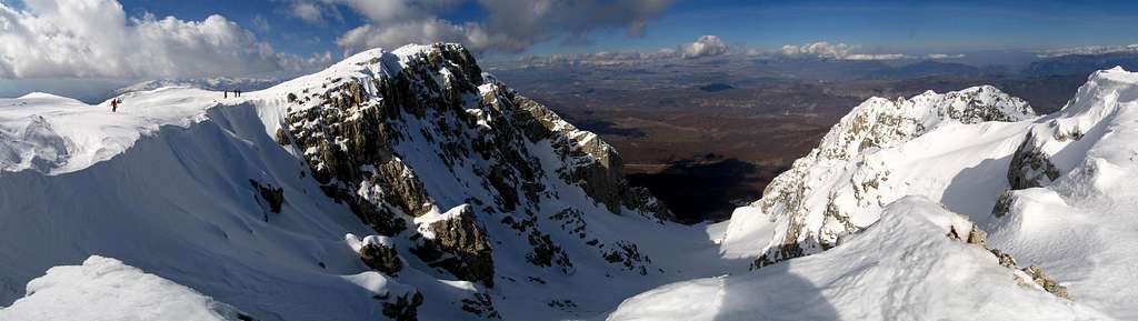
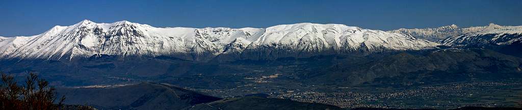
Panorama and sceneries
|
|
Books, guides, maps, external links
Books
- S. Ardito, A piedi sul Sirente Velino, ed. Iter
- S. Ardito, A piedi in Abruzzo Vol. 1, ed. Iter
- N. Galiè, G. Vecchioni, Sirente Velino le più belle escursioni, ed. SER
- C. Coronati, P. Turitto, Sci escursionismo fra Lazio e Abruzzo Vol. I, ed. Il Lupo
Maps
- Velino-Sirente 1:25.000, edited by Cai L'Aquiila
- Velno-Sirente I sentieri montani del gruppo Velino-Sirente 1:25.000, edited by Il Lupo
Meteo links
- Weather conditions in Rocca di Mezzo
- Weather forecast in Ovindoli
- Avalanche bulletin for Central Apennines