
-
 8788 Hits
-
 91.75% Score
-
 36 Votes
|
|
Mountain/Rock |
|---|---|
|
|
46.49473°N / 10.52422°E |
|
|
Lombardia |
|
|
Mountaineering, Trad Climbing, Ice Climbing, Mixed |
|
|
Summer |
|
|
11982 ft / 3652 m |
|
|
Overview
Thurwieser Spitze (Punta Thurwieser) 3652 m
Punta Thurwieser is an icy pyramidal peak belonging to the Trafoi-Thurwieser subgroup and lying on a mighty branch West to Ortles-Koenig Spitze main ridge; its West ridge joins it to another mighty threethousander peak, the Trafoier Eiswand (Cima di Trafoi), while a high icy col, named Passo Thurwieser, separates it from a couple of other interesting peaks, Grosser Eiskogel and Kleiner Eiskogel (Gran Cono di Ghiaccio and Piccolo Cono di Ghiaccio). The superb snowy North-East ridge, starting just from the Thurwieser Col, gives to Punta Thurwieser an unmistakable shape.
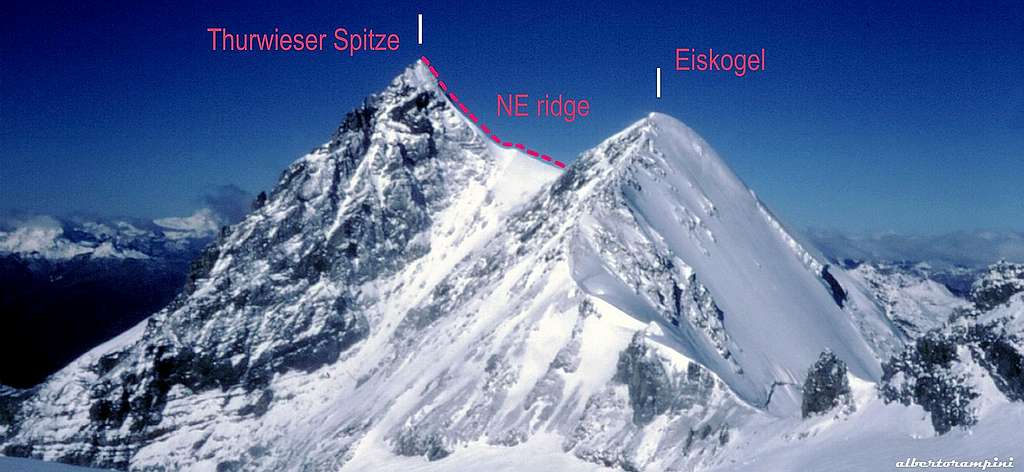
Punta Thurwieser North-East ridge
Though not much frequented because of its secluded position, Punta Thurwieser is one of the finest peak of the Ortles-Cevedale massif. The place-name Thurwieser is in memory of Peter Carl Thurwieser from Salzburg (Austria), one of the first summiters of Ortles. Being the peak surrounded by the most important summits of the group, the superb Gran Zebrù, Monte Zebrù, Ortles and Cima di Trafoi, the summit view is quite spectacular. The most attended route is the one running on the North-East ridge, approachable from V Alpini Hut in upper Val Zebrù.
Getting There
ROAD ACCESS
The starting point is the little settlement of San Nicolò Valfurva, 3 km. from Bormio, a main destination which can be approached from Milan following the Valtellina and from Alto-Adige through the Stelvio Pass.
APPROACH TO RIFUGIO V ALPINI
From San Nicolò Valfurva follow the narrow road entering Val Zebrù, crossing the small settlement of Plazzola and Niblogo and leading to Tre Croci parking m. 1610, besides which the private cars are not allowed. From here carry on walking along the main gravel road running inside Val Zebrù, reaching the alpine “baita” Zebrù di fuori and Zebrù di Dentro m. 1870, then Baita del Pastore m. 2168 and ending at m. 2525 (about 3 hours by walking from the parking). From here a good path follows the moraine, leading to the V Alpini Hut m. 2877 (about 4 hours from Tre Croci parking).
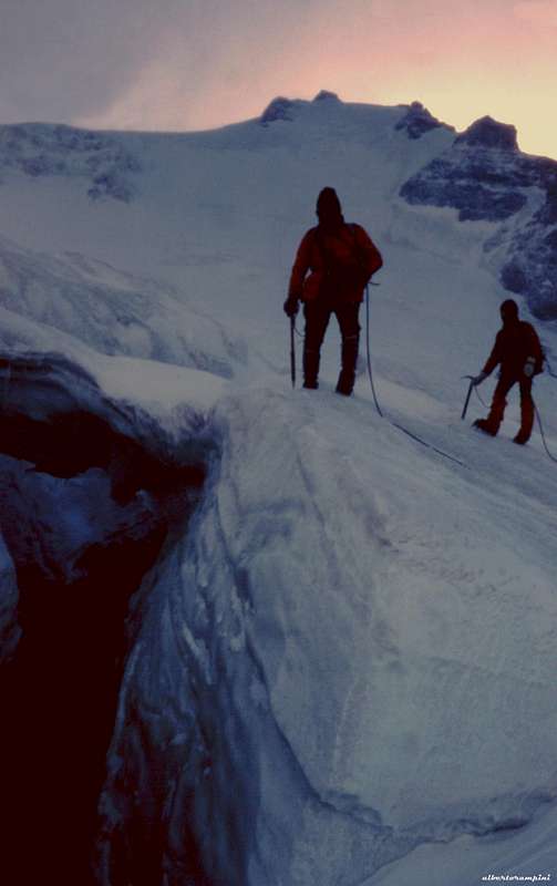
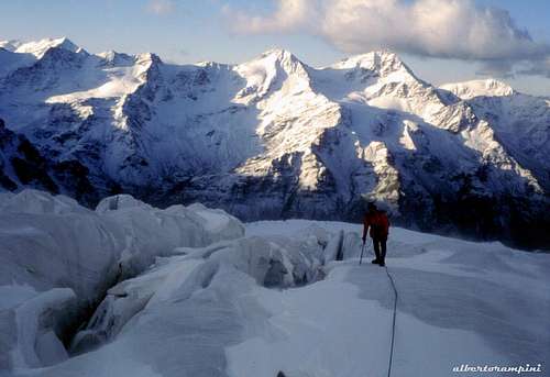
A deep crevasse on Vedretta Zebrù |
Starting point of the glacier |
APPROACH TO PASSO THURWIESER
From V Alpini Hut follow the path towards Vedretta dello Zebrù (Zebrù Glacier); cross the Eastern branch of the glacier, then follow the Western one towards North keeping yourself in the middle and reaching a 300 m. high snowy gully facing SE, leading to Passo Thurwieser.
Punta Thurwieser best routes
NE Ridge
Difficulty: Alpine AD
Length: 300 m.
Exposure: NE
First ascent: Theodor Harpprecht with Josef Schnell 21-8-1869
Starting point: Passo Thurwieser (Thurwieser-Joch) m. 3480
Beautiful ascent, the most frequented on the mountain.
From the Rifugio V Alpini follow the path towards Vedretta dello Zebrù (Zebrù Glacier); cross the Eastern branch of the glacier, then follow the Western branch towards North keeping yourself in the middle and reaching a 300 m. high snowy gully facing SE, leading to Passo Thurwieser.

|

|
N FACE
Difficulty: Alpine D-
Length: 250 m.
Exposure: N First ascent: Eugen Guido Lammer alone 19-8-1893
Starting pont: Passo Thurwieser m. 3480 or Pelliccioli Bivouac m. 3230
The most classic climb amongst the lines running on North and North West faces; as all the routes on this face, it counts few repetitions.
W RIDGE (BAECKMANN GRAT)
Difficulty: Alpine D
Length: 800 m.
Exposure: W
First ascent: Carl Backmann with Alois Kuntner and Alois Pinggera 16-9-1890
First integral ascent: Richard and Rudiger Weitzenboch
Starting point: Cima di Trafoi summit
Descent: following the NE ridge.
Vedretta dello Zebrù
Huts and Bivouacs
***Rifugio V Alpini m. 2877 - C.A.I. Milano – 60 beds, open from middle june to middle September RIFUGIO V ALPINI

|

|
***Bivacco Città di Cantù al Giogo Alto (Hochjoch) m. 3535 – C.A.I. Cantù – 9 places, always open
***Bivacco Leone Pelliccioli m. 3230 – C.A.I. Bergamo – 6 places, always open
Red Tape
A wild environment lying inside Parco Nazionale dello Stelvio. No particulary restrictions in hiking and climbing. Cars are not allowed beyond the Tre Croci parking.
When to climb
Best season goes from the end of June to middle September
Meteo

METEO BOLZANO
DOLOMITI METEO - ALTO ADIGE
METEO LOMBARDIA
Guidebooks and maps
 |
 |
“Ortles-Cevedale – Parco Nazionale dello Stelvio” by Gino Buscaini – Collana CAI-TCI Guide dei Monti d’Italia
Map “Ortles-Cevedale” , foglio 72 - Kompass 1:50.000