
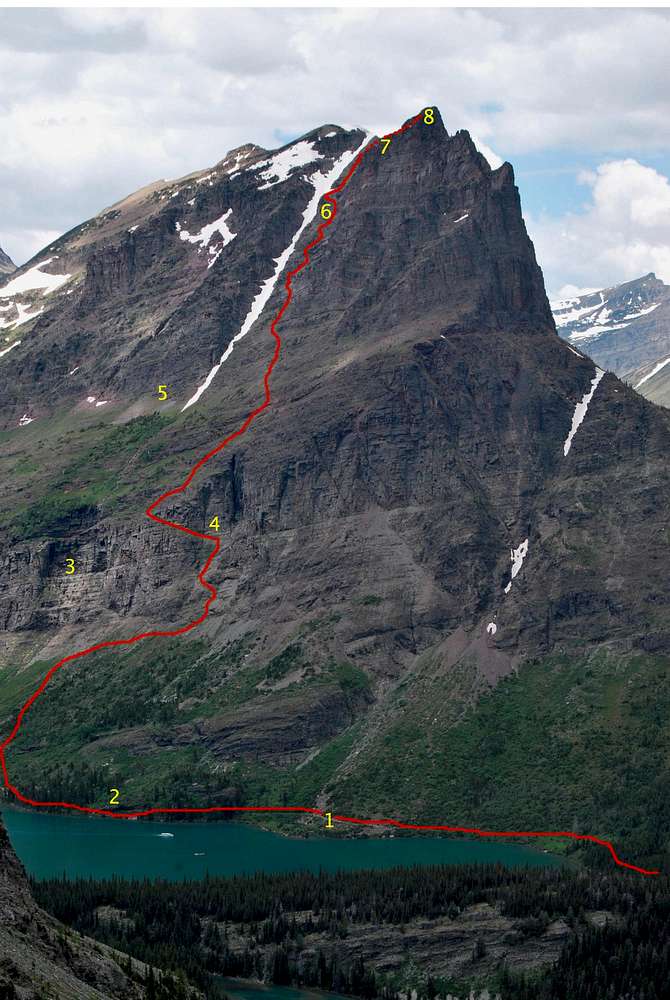
I reworked this photo to provide a better outline after completing this route for a third time during June of 2013. My goal is to make this complicated and potentially dangerous route as clear as possible. Please note that a climber died on the lower portion of this route in July of 2013 while attempting to access the steep couloir that provides the only plausible way to gain the grassy ramp. If you ever find yourself contemplating moves worse than Class III, find a safe place to study the route and look for the easiest possible terrain.
After hiking around Swiftcurrent Lake, follow trail signs to the North Shore of Lake Josephine. As the trail winds past the boat dock and around the lake, take note of a small pond ( 1 ) on your left that will likely hold chunks of ice and snow well into late summer. Soon after, you'll notice a steep, dark cliff to the right (west) that slightly overhangs the trail ( 2 ). Continue on the trail for about 5 minutes, passing through a short forested section. Soon after breaking out of the forest, pause to study the incredible cliffs to your right (west). You should notice a sheer, wet cliff several hundred feet tall well above the trail ( 3 ). Leave the trail when immediately below the wet cliff and slog uphill through steep meadows to the grassy area directly below that cliff. Make your way right (north) along the base of the cliff for a couple of hundred feet until a broad, steep couloir is encountered. Look for a Class III route to access the couloir, then scramble uphill until reaching a very obvious game trail that ascends to the south on a steep grassy ramp ( 4 ). Head uphill and to the right once the terrain mellows above the grassy ramp, and seek the route of least resistance through several small cliff bands interspersed with steep meadows and ledges. Eventually, you will reach a very prominent trail that leads uphill to the right (north); a short detour downhill will lead you to the old Josephine Mine ( 5 ). A large, persistent snow chute leads up a steep break in the mountain above the mine; the route will zig-zag along the north side of the chute, and if care is taken in route finding, nothing worse than Class III should be encountered. The crux of this portion of the route involves utilizing a small pillar ( 6 ) very near the snow chute to avoid an otherwise frightening 30 foot cliff. After this move is negotiated, a large scree slope is encountered. Head uphill to the right, but avoid the temptation to scramble up to the ridgetop. Traverse underneath impressive green lichen-covered cliffs ( 7 ), following well-worn trails that should lead to the massive summit cairn. Enjoy the summit views ( 8 )!!!!!
July 6, 2010
(Route diagram reworked on February 5, 2014)


