36 miles, 10000’ gain-24.5 hours
Counter-clockwise starting from Crater Lake Lodge
Participants: Sarah Strattan & Kevin Baker
August 23-24, 2014
Slideshow
Full Res Images, Including North Sister, Middle Sister, Thielsen hikes
"On the evening of the first day, while riding up a long, sloping mountain, we suddenly came in sight of water, and were very much surprised, as we did not expect to see any lakes, and did not know but what we had come in sight of and close to Klamath Lake, and not until my mule stopped within a few feet of the rim of Crater Lake did I look down, and if I had been riding a blind mule I firmly believe I would have ridden over the edge to death and destruction. We came to the lake a very little to the right of a small sloping butte or mountain, situated in the lake, with a top somewhat flattened. Every man of the party gazed with wonder at the sight before him, and each in his own peculiar way gave expression to the thoughts within him; but we had no time to lose, and after rolling some boulders down the side of the lake, we rode to the left, as near the rim as possible, past the butte, looking to see an outlet for the lake, but we could find none. "
-John Wesley Hillman-discoverer of Crater Lake, 1853
I came to Oregon back in April and made my first visit to Crater Lake. I was blown away and inspired by the enchanting scenery cloaked under spring snow. I had ambitious plans to hit Garfield and Applegate, two “easy” summits not too far from the Crater Lake Lodge. My friend and I were turned back less than a mile from the trailhead by bulletproof snow that would have been a front pointing affair for a long way with big consequences for a fall! I vowed to soon return and wondered what it would be like to traverse all the way around the lake staying or near the crest of the rim.
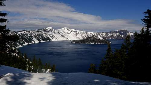
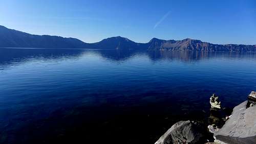
![Crater Lake]() Crater Lake
Crater LakeI figured August would be the best month to try it when all the snow and mosquitoes were gone. I booked a flight for late August and hoped for the best with the weather. A quick Google search on the Crater Lake traverse turned up very little information, which is surprising considering this is a national park! There was some information on Summitpost on some of the peaks, but not on a full rim traverse. I guess this isn’t popular because a fit hiker could hit all the summits in a day via individual hikes moving your car from one “trailhead” to the next. I did read a few reports of skiers who skin the road in winter, which would be a heck of a death march! About 16 miles of the traverse was on trail or road, or 44%. Most of this was on the second day.
My friend Sarah is working in the Grants Pass area for the forest service this summer and was up for the challenge! It was great to have her along, because doing this solo would be tough mentally! We really had no idea of how long this would take, but we did decide to bring some overnight gear in the likely event that we could not pull this off in a day. This turned out to be a pipe dream, because the first third of the traverse is pretty slow going!
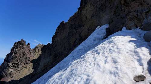
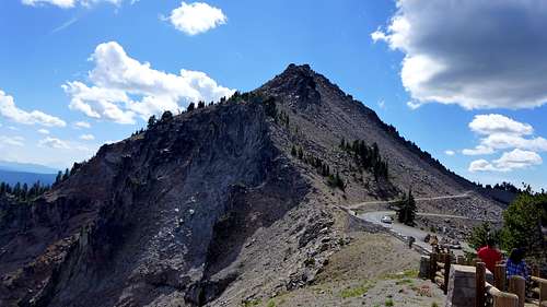
I arrived in Oregon a couple days early to hit some hikes I have been eyeing in the Cascades. I made a valiant solo effort on North Sister, but was turned back by a steep snowfield on the Terrible Traverse that I didn’t want to risk crossing sans axe and crampons. There was a moat at the top of the snow next to the cliff that I went up a bit, but I didn’t like the thought of downclimbing one section. Middle Sister was a nice consolation prize.
![Unnamed Image]() Hard snow on the Terrible Traverse on North Sister turns me back.
Hard snow on the Terrible Traverse on North Sister turns me back.The next day I hit Thielsen, which is a sweet half day scramble with an exciting 4thclass finish.
![Below the summit pinnacle on Thielsen]() Below the summit pinnacle on Thielsen
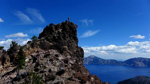
Below the summit pinnacle on ThielsenI met Sarah the night before the traverse in Chiloquin for a hearty meal to fuel up for the daunting task ahead. We drove our cars to the Crater Lake Lodge at the south side of the park and slept there for a few hours. We set out from the lodge at 4:33am in hopes of catching the sunrise from the summit of Garfield, 1.7 miles in with a nice trail to the top. We had to carry enough water to get us to Cleetwood Cove, as there was no water until then. I brought 3.5 liters and just got by. My pack weight was somewhere around 25 pounds with the water and what I thought was a bunch of food, but I burned through the food quick! The trail was very nice and we kept our pace down for the long day ahead. The lake started to reveal itself as the sky started to light up. We hit the summit of Garfield well before sunrise at 5:40 and decided to keep moving. The descent of Garfield was quick and we were soon approaching Dyar Rock, a 4th class unranked tower that we hoped we could find a safe line up. We found the easiest route to be on the east face. We took different lines, Sarah going up a chimney on the s.e. side and my route was a bit north with one 4th class mantel move. The views from the top of this cool little tower were spectacular to say the least!
![Dramatic Dyar Rock at Crater Lake]() Dramatic Dyar Rock at Crater Lake
Dramatic Dyar Rock at Crater LakeThe sun still hadn’t risen yet, so we headed for Applegate, which is a quick 400’ hike from the saddle with Dyar Rock. The sun rose just before we topped out on Applegate.
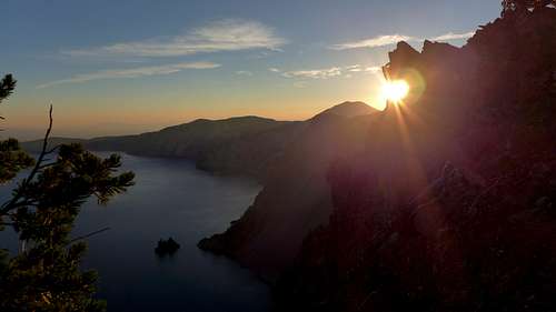
![Sunrise over Crater Lake]() Sunrise over Crater Lake
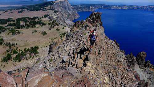
Sunrise over Crater LakeWe weren’t in the best position to enjoy it, but it was still pretty sweet! We topped out on the surprisingly small summit of Applegate at 7:09am and took a snack break to ponder our future, because the easy terrain was over for awhile! There is one TR of some of the peaks on the Crater Lake rim on Summitpost and the writer mentioned a couloir on the east face of Applegate that he ascended, but he didn’t go down that way. Everything we saw off the summit looked steep on ball bearing scree with mini cliffs bands to navigate, so we angled s.e. and hoped to find a weakness without having to get too far away from the rim. We contoured above a cliff at about 7620’ and had to go back up a bit before finding a reasonable downclimb that breached the cliffs. Staying on the south ridge until you see a weakness will save you the headache that we had. A nasty boulder field awaited us below the cliffs, and I decided to just hit the road and go up to the Sun Notch saddle from there while Sarah stayed high. We met back up at Sun Notch after I wasted a few minutes wondering where I would find her. We were relieved to get out of that mess, but the worst part of the day was yet to come!
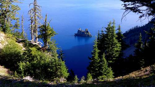
![The Phantom Ship]() The Phantom Ship
The Phantom Ship![The east face of Applegate Peak]() The east face of Applegate Peak
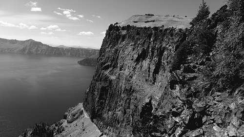
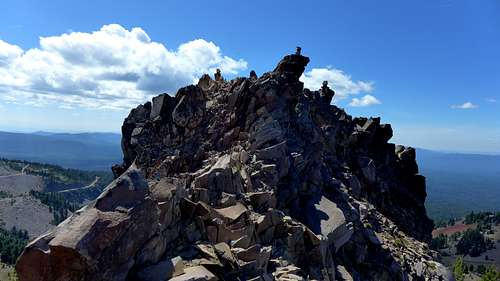
The east face of Applegate PeakNext up was Dutton Ridge, which is a 1000’ grunt from Sun Notch. Sun Notch afforded some awesome views of the Phantom Ship, a jagged island with many spires. I wonder if anybody has climbed anything on this tiny perch! The trees were pretty thin here, and we more or less stayed just south of the rim crest with a few minor scrambling sections. We topped out on the non-descript summit at 9:52am and decided to keep moving as the last section took a lot longer than anticipated. The last crux of the day was getting off Dutton Ridge to Kerr Notch. I told Sarah that I knew the ridge was sharp from images on Google Earth and that it likely wouldn’t go. There are steep contour lines on the map south of the rim, but it looked like there were plenty of trees on the face to find a weakness. We were able to follow the ridge down to 7400’ and it indeed did cliff out, just 600’ above the road. My advice for descending DuttonRidge is to take a s.e. heading off the summit into the trees to avoid a series of deceiving mini cliff bands that never seem to end. There are not many options getting down the way we went, and the terrain was extremely loose and unpleasant. It took a ton of routefinding and tedious sidehilling on some very nasty, exposed terrain, and we were relieved to finally be off of it after burning 2 hours!
![East face of Dutton Ridge]() East face of Dutton Ridge. Don't get enticed by the initial gentle ridge. Take the south ridge until you see a suitable line to the southeast. The cliffs above the road don't have many weaknesses!
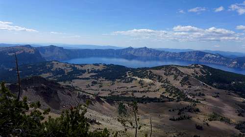
East face of Dutton Ridge. Don't get enticed by the initial gentle ridge. Take the south ridge until you see a suitable line to the southeast. The cliffs above the road don't have many weaknesses!Needless to say, our chances of getting to Cleetwood Cove, near the halfway point, were doubtful. We were both feeling pretty worn out at this point and the morale was low as we had another 800’ of annoying, steep bushwacking to finally get to easy terrain. There was a bike event going on at the time and as we past a pullout at Kerr Notch, the bikers were having a nice snack at an aid station. We were so jealous of the food! The grunt was miserable as expected with limited views of the lake, but we finally got to an easy meadow and it was decision time. Do we hit Mount Scott now or Sun after we finish the traverse as a separate hike? It would add 5 miles and 1700’ to an already long day, but we would get a break with a nice trail and we could ditch the packs for a while! We decided to go for Scott now. We were rejuvenated after taking a quick break where we hit the trail just a bit south of the trailhead. We counted a total of 64 people on the hike and topped out at 2:45pm, my first national park highpoint since Horse Ranch Mountain in Zion back in 2009! We took a long break here and chatted with some of the folks on the summit. Scott has a very nice view of the lake even though it’s about 2 ¼ miles east of the rim.
![Mount Scott summit]() Mount Scott summit
Mount Scott summit![Mount Scott summit views]() Mount Scott summit views
Mount Scott summit viewsFor the remainder of the day, we tried to take it one step at a time and not think too much about how far we could get. Most of the vertical was now done for the day, and we hoped the bushwacking wouldn’t be too bad. Our last summit of the day was Cloudcap, and the true summit is a bit s.e. of the overlook. After Cloudcap, we headed north pretty close to the rim and we were relieved that the terrain was easy as expected. We took a break at two overlooks and decided to call it a day near a feature called Wineglass, near the summit of Roundtop. We called it a day at 7pm after 14.5 hours, 19 miles, and 5800’ gain. We both didn’t bring a stove to save weight so the dinners were a bit less than spectacular. I had some canned fish wrapped in tortillas and Sarah shared some of her veggies with me. I sure hoped the next day would be easier, because I was already running low on food!
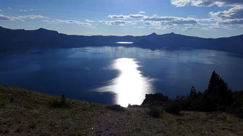
![Late afternoon reflections on Crater Lake]() Late afternoon reflections on Crater Lake
Late afternoon reflections on Crater Lake![Sunset over Crater Lake]() Sunset over Crater Lake
Sunset over Crater LakeDay 2-Much Easier!
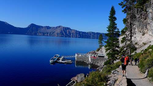
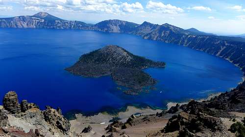
We both were looking forward to an easier day as once we got over Llao Rock, it was all trail miles! We also were looking forward to descending to the lake at Cleetwood Cove to get water and clean up a bit. The sunrise wasn’t quite as good as the first day, but it still was an awesome setting! We set out at 7am, with only a 3.5 mile hike to Cleetwood Cove. We went over unranked bumps Roundtop and Mazama Rock on the way, and the bushwacking was pretty easy. We hit the Cleetwood Cove trailhead fairly quickly and I cached some of my gear in the trees so I didn’t have to haul it back up to the rim from the shore. The trail was pretty busy as the first boats were about to set off for Wizard Island. Apparently there are 3 different tours you can take on the lake. I will have to come back for Wizard Island someday, although you do have to put up with the touristy crap on the boat ride. We hit the shore just under 2 hours from camp and it felt good to get water from one of the cleanest lakes in the world, although we did use Sarah’s steripen just to be safe!
![Cleetwood Cove]() Cleetwood Cove
Cleetwood Cove
![Crater Lake from Cleetwood Cove]() Crater Lake from Cleetwood Cove
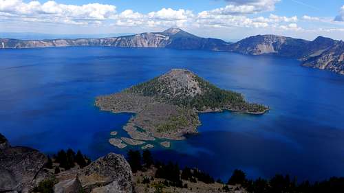
Crater Lake from Cleetwood CoveCrater Lake is a staggering 1,943 feet deep at its deepest point and is the deepest lake in the US. It is also the 9th deepest lake in the world, but if you measure by average depth, it checks in at 3rd deepest in the world! In 1997, scientists recorded a water clarity record of 142 feet. All of the water in the lake is from precipitation and no streams leave or enter it, which is a big reason why it is so blue and clear.
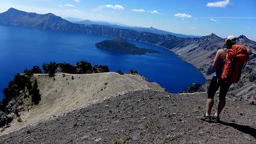
After a nice break at the lake shore, we headed back up the 1 mile and 600’ to the rim. For the sake of time, we decided to follow the road for the next section of the hike until we were closest to the n.e. ridge of Llao Rock at 7160’. From there, it was a fairly easy grunt to treeline, where we were afforded some spectacular views of the lake above the sheer cliffs of Llao Rock. I thought the next 3 summits had the best views of the traverse. We topped out around noon, and were relieved to know that we would soon be hitting the Rim Trail at the next saddle! We bombed down the north ridge of Llao Rock and I commented that you had to step “gingerly” on the soft ash as there were holes here and there. On Day 1, I almost hyperextended my knee stepping into one of these holes! Sarah had never heard of the word gingerly,probably because it isn’t from her generation!
![Llao Rock]() Llao Rock
Llao Rock![Llao Rock summit views]() Llao Rock summit views
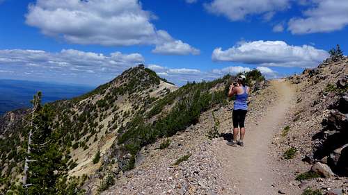
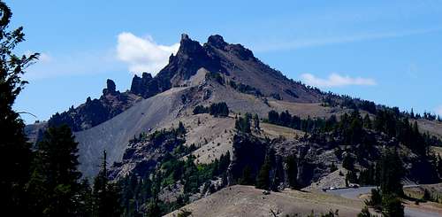
Llao Rock summit viewsThe descent down to Merriam Point and the land of the tourists was cruiser and with renewed vigor, we finally hit the trail. We were now down to Hillman and The Watchman next, and Hillman looked like it could be an interesting scramble from afar. We picked up unranked Devil’s Backbone on the way to Hillman and Sarah went to the cooler more dramatic sub-summit. The map suggested that the trail passed to within 100’ of Hillman, but that was an error. We left the trail shortly after Devil’sBackbone, and it was an easy traverse to the loose north face, where we grunted up a nasty scree field to the saddle between the two summits. Sarah had more energy than me and went over to the 4th class, lower eastern summit. I kind of wished I would have went over, because it was probably cooler than the true summit! The ridge between the two is exposed on the lake side, with a few loose third class moves to gain the summit. Check your holds on this one!
![Hillman Peak]() Hillman Peak
Hillman Peak![The north summit of Hillman Peak.]() The north summit of Hillman Peak.
The north summit of Hillman Peak.![Hillman Peak summit block]() Hillman Peak summit block
Hillman Peak summit block![North ridge of Hillman]() North ridge of Hillman
North ridge of Hillman![Wizard Island from Hillman]() Wizard Island from Hillman
Wizard Island from HillmanI checked out a descent off the s.w. side so we could avoid going down the nasty scree, and it indeed did go and was more fun than the way we went up as it was pretty solid for volcanic rock. The last ranked peak of the day was the popular Watchman, which has a wide trail, many switchbacks, and a lookout on top. We topped out at 3pm with about 20 other people there and there were great views of Wizard Island from here.
![The Watchman]() The Watchman
The Watchman![Wizard Island from The Watchman]() Wizard Island from The Watchman
Wizard Island from The WatchmanFrom the summit of The Watchman, it was only about 3.5 miles back to the lodge over a gentle rolling trail with some minor uphills. Those short uphills were killer after all that vertical though! This section of trail is great for the casual tourist and has some awesome vantage points. We were surprised there weren’t many people on this section. I finished up with a lame unranked bump called Munson Ridge in the picnic area near the lodge and we finally finished a bit before 5pm for a 10 hour, 17.2 mile, 4000’ vertical day.
All in all, I thought the traverse was an awesome experience seeing Crater Lake in a way that few people get to see even though there are many overlooks along the road. The scenes really changed throughout the trip and it was a privilege to experience the many appearances of this amazing place. The major summits can be hit in a day driving between them, but I thought it was more of a complete experience by hiking around the entire rim. If I would have studied the map more and tried not to force the route off Applegate and Dutton Ridge, the experience on the first day would have been a lot less demanding! It was an experience I won’t forget and thanks to Sarah for being a solid partner.


Comments
Post a Comment