
-
 56829 Hits
-
 84.81% Score
-
 19 Votes
|
|
Mountain/Rock |
|---|---|
|
|
36.52620°N / 118.478°W |
|
|
13802 ft / 4207 m |
|
|
Overview
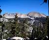
Mt Kaweah is the highest point in the southwestern Sierras, higher than anything west of the Kern Canyon, including the entire Great Western Divide. This earns it a spot as one of the 15 Emblem Peaks on the Sierra Peaks Section Peaks List.
It has a commanding view of some of the finest high country around, and it's all wilderness - no cities, no roads, no power lines. As a class 1 peak it is technically a piece of cake, but provides a greater challenge than bagging some other class 1's like Whitney or Langley.
Mt. Kaweah is not climbed so frequently as some of the other "Emblems". It had, when I was there, 2 small summit register books, both over 10 years old, but less than half full - gone now. According to Bob Burd's Emblem Peaks List, the mileage and the elevation gain to reach Mt. Kaweah are both greater than for any of the other 14 emblem peaks.
Some discussion of first ascents and naming of Kaweah peaks is given at http://www.yosemite.ca.us/history/place_names_of_the_high_sierra/k.html. They say “Kaweah River is named after a Yokuts tribe called Kawia, or probably more exactly, Gā'wia. They lived on or near the river where it emerges from the foothills into the plains.
Although it is not a point on the lofty western divide of the upper Kern River basin, it was long believed to be the source of the Kaweah River. Some people still refer to Mt. Kaweah as the highest peak of the Great Western divide, while that distinction more properly belongs to Midway Mountain at 13,666'.
 |
 |
Getting There
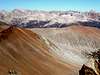
The peak is a 3 mile hike off the High Sierra Trail, above Big Arroyo. The quickest way in is via the easy class 3 Glacier Pass, then over Blackrock Pass and down past Little Five Lakes. From the Sawtooth Pass trailhead in Mineral King, you can either go over Glacier Pass, or go north over Timber Gap, and connect to the Cliff Creek trail to Blackrock Pass. The route, west over Sawtooth Pass, down Lost Canyon and north up past Big Five Lakes to Little Five Lakes is also nice. Coming in along the High Sierra Trail from Giant Forest or Lodgepole would probably take a little longer, but I hear it's very beautiful.
Getting there is half the fun. The trip takes you over high mountain passes, past granite peaks and through valleys showing interesting geologic features and effects of glaciation. You end up in a beautiful, remote part of the wilderness. For the non-wilderness part of getting to Mineral King, see Steve Eckert's driving directions at http://www.climber.org/DrivingDirections/MineralKing.html. Remember to allow a full hour for the last 25 miles of the drive!
Glacier Pass could be dicey with a lot of snow on it, and it looks like it would retain snow later than usual in the season. Secor says it may be blocked by a cornice in the spring.
Red Tape
The usual Red Tape for Sequoia National Park wilderness areas applies here. It's all described at http://www.nps.gov/seki/planyourvisit/wilderness.htm . You are required to have a wilderness permit, bear-proof food storage, and to practice minimum impact camping.
No fee is required to drive into the Mineral King area, but to enter the main park to get to the western end of the High Sierra Trail always requires a park entrance fee.
In 2007, quotas will be in place from May 25 to September 23. Quotas limit the number of people entering each trailhead on a single day. During this quota season, permits require a $15 wilderness camping fee.
When To Climb
Climb when the snow is consolidated, or gone. The trails I took were very steep,and I saw evidence of avalanche damage. It took me 3 days in September, so I imagine February would be pretty darn tough.
Mineral King is closed November 1 until late May - open for Memorial Day weekend, weather permitting.
Camping
It's nice to camp near a bear box, so you don't have to carry a bear canister. All the Bear Boxes I saw had a little map inside them showing where the established campsites in the immediate vicinity are located.
The NPS describes the location of SEKI bear boxes at http://www.nps.gov/seki/planyourvisit/bear_box.htm , but Steve Eckert maintains a much better resource at http://www.climber.org/data/BearBoxes.html . For a map and waypoints of bear boxes in the Big Arroyo area, see http://www.climber.org/data/BearBoxes/BA.html.
Mountain Conditions
The NPS web site at http://www.nps.gov/seki/index.htm should lead you to good information on Mineral King and Sequoia parks. See Trail Conditions, Special Conditions and Closures, and weather.
You can call the nearest ranger at:
Mineral King Ranger Station
Late May - Early September 8am-4:30pm
Hours may vary early and late in the season
Phone 559-565-3768
NOAA (national weather service) Weather forecast for Lat/Lon: 36.5262 -118.4775 Elevation: 12375 ft (that's as close as I could get it to the top of Mt Kaweah!) is at http://www.wrh.noaa.gov/total_forecast/index.php?wfo=hnx&zone=caz097&fire=caz297&county=cac107&dgtl=1&lat=36.5262&lon=-118.4775 - this is a useful web page, with links to road conditions and other types of forecasts and weather display for the region.
Maps
The Mt Kaweah Topographical map quad is available as a 4.8 Megabyte "png" picture file, here.
I like it when the map has that legend at the bottom showing symbols for different types of roads and highways, but there are absolutely no roads on the entire map !
It takes 3 more maps to cover the route I took.
o36118e5 Triple Divide Pk.
o36118d5 Mineral King
o36118d4 Chagoopa Falls
Still want more maps ?... then go to http://langenbacher.org/Maps
Get the full sized (2390 x 2054 Pixel) map of my route at http://langenbacher.org/Maps/KaweahTrip.jpg . It's a big file - 5.57 Megabyte. My route appears Violet (Mineral King to "Turnoff"), then Cyan (From High Sierra Trail to Mt. Kaweah), then Green (Mt Kaweah to High Sierra Trail), then Violet (Back to Little 5 Lakes), then Green (Little 5 to Mineral King). Definitely not the shortest route, but colorful!
.png)
.png)
.png)
.png)
 |
External Links
- Mike McDermitt's trip report
Contains some useful route discussion. - http://www.snwburd.com/bob/emblem/peaks/kaweah.html
Bob Burd's Mt. Kaweah page with maps, trip reports, and Etymology. - Class 3, northeast face from Kaweah Basin route description by Reiner Stenzel.
- My (Harry's) trip report at http://climber.org/TripReports/2005/1449.html