Overview
![Samspitze]() Samspitze beneath Villanderer Berg Samspitze beneath Villanderer Berg |
Above the pilgrimage chapel at
Latzfonser Kreuz / San Croce di Lazfons, the highest such sanctuary in
Südtirol / Alto Adige, you can find a cirque of three mountains:
Cassianspitze / Cima San Cassiano,
Ritzlarspitze and
Samspitze. The latter two - as to my knowledge - carry only German names, an indication that in this part of the
Sarntal Alps / Monti Sarentini the German language is still spoken almost exclusively though the area has belonged to Italy for more than 90 years now. Together, the three mountains are the last outpost of the higher part of the
Sarntal Alps / Monti Sarentini standing above the huge pasture of
Villanderer Alm which stretches all the way to
Rittner Horn / Corno Renon some dozen kilometres to the south.
Samspitze, also simply called
Sam is the second highest summit of the trinity, standing to the south-west of the cirque, which is open to the south. At its eastern base inside the cirque you can find
Kassiansee / Lago San Cassiano, a mountain lake in beautiful surroundings. While the ascent routes to
Samspitze are far from difficult they still are more serious than the routes to the other two mountains of the cirque. From
Latzfonser Kreuz / San Croce di Lazfons you either scramble up the south slopes of the mountains (no trail or markers) or use part of the ascent routes to the higher
Kassianspitze / Cima San Cassiano to traverse the Samspitze north ridge. The latter is considerably exposed though you cannot seriously call it a knife-edge.
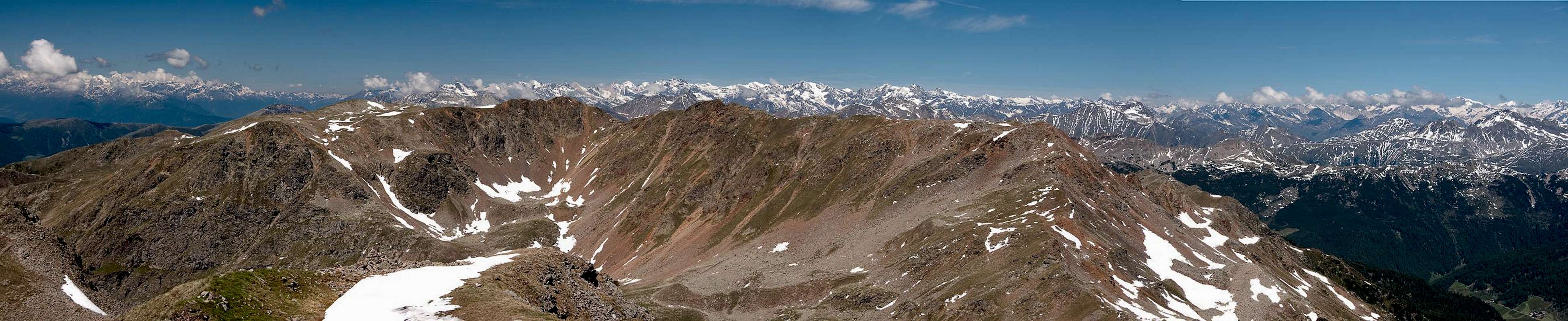
In consequence the summit cross of
Samspitze is not as popular a destination as the ones of its neighbours. However, views are also exceptional, especially when considering the wide panorama of the Dolomites acoss
Eisacktal / Valle d'Isarco in the east. To the north
Kassianspitze hides part of the vista of the
Zillertal Alps and
Ötztal Alps and
Ortler Goup hover above the
Blankenhorn / Getrumspitze Ridge in the west. On clear days you won't be willing to leave ...
Some Views
Blankenhorn and Getrumspitze seen from Samspitze |
![Geisler / Odle Group]() Geisler Group Geisler Group |
![Pflerscher and Gschnitzer Tribulaun]() Pflerscher and Gschnitzer Tribulaun Pflerscher and Gschnitzer Tribulaun | ![Peitlerkofel]() Peitlerkofel Peitlerkofel | ![Zehner and Heiligkreuzkofel]() Zehner and Heiligkreuzkofel Zehner and Heiligkreuzkofel |
![Le Tofane]() Tofane Tofane | ![Sella Group]() Sella Group Sella Group | ![Langkofel Group]() Langkofel Group Langkofel Group |
Getting There
There are two reasonable trailheads for
Samspitze, one at
Reinswald / San Martino in
Sarntal / Val Sarentino (or rather
Durnholztal / Valdurna) and
Lazfons in
Eisacktal / Valle Isarco. Both trailheads are connected by the pilgrimage trail to the sanctuary at
Lazfonser Kreuz / S. Croce di Lazfons
- Reinswald / San Martino trailhead
- Take Brenner Motorway A22 to Bozen / Bolzano
- Drive through the city, following signs to Sarntal / Val Sarentino on SS508
- At Astfeld / Campolasta turn off onto SP137, direction Durnholz / Valdurna
- At Unterreinswald / San Martino Bassa turn onto SP138 to Reinswald / San Martino. Park at the cable-car station.
- Lazfons trailhead
- Take Brenner motorway A22 to the exit Klausen / Chiusa.
- Take SP74 to Feldthurns / Velturno
- Turn left onto SP142 to Lazfons
Red Tape
There's no red tape. You might have to cross pasture gates which you are requested to shut behind you.
Accommodation
Eisacktal / Valle Isarco
Bozen / Bolzano
Weather Conditions
Maps & Books
Maps
- Digital Maps
- Regular Maps
- Sarntal/Val Sarentino
Kompass Map WK 056
1:35.000
ISBN: 3-85491-340-0
- Brixen / Bressanone
Kompass Map WK 56
1:50.000
ISBN: 3-85491-063-0
- Bozen / Bolzano
Kompass Map WK 54
1:50.000
ISBN: 3-85491-061-4
- BOLZANO-RENON / BOZEN-RITTEN-TSCHÖGGLBERG
Tabacco Map 034
1:25.000
- MONTE SARENTINI / SARNTALER ALPEN
Tabacco Map 040
1:25.000
Books
- Bozen-Salten-Schlern
Kompass Guidebook WF953
Kompass Verlag
ISBN: 3-85491-406-7
- Rund um Bozen
Helmut Dumler
Rother Verlag
ISBN: 3-7633-4267-2

 4837 Hits
 81.84% Score
 14 Votes
 Samspitze beneath Villanderer Berg


 Geisler Group
 Pflerscher and Gschnitzer Tribulaun
 Peitlerkofel
 Zehner and Heiligkreuzkofel
 Tofane
 Sella Group
 Langkofel Group