
-
 47680 Hits
-
 90.6% Score
-
 33 Votes
|
|
Mountain/Rock |
|---|---|
|
|
37.79910°N / 107.8284°W |
|
|
13894 ft / 4235 m |
|
|
Ice Lake Basin Overview
West of the small Colorado mining town of Silverton sits a beautiful place called Ice Lakes Basin, arguably one of the most aesthetically-pleasing basins in the San Juan Range. Ice Lakes Basin is east of the high ridge of thirteeners from north to south: U.S. Grant Peak, "V4", Pilot Knob, Golden Horn, Vermilion Peak & Fuller Peak.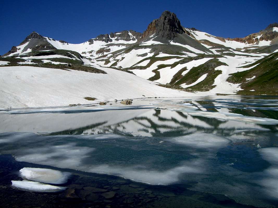
Ice Lake. Left to right: Fuller Peak, Vermilion Peak & UN13230. Photo: altitude14er
Vermilion Peak Overview
Vermilion Peak is the tallest of a series of high, rugged thirteeners that surround this scenic location. Named for the reddish/orange tinge that the peak takes on, Vermilion provides an amazing view when looking at it from the south. When the sun hits it right, the peak appears to almost glow of red and orange (Vermilion means "flame-red"). Many people choose to backpack into Ice Lakes Basin, this way being able to incorporate climbs of Golden Horn, Pilot Knob, US Grant Peak, or Fuller Peak, the other high thirteeners in the area. San Juan County does not have a 14er, but it does have Vermilion (the highest peak in the county), and it is definitely worth climbing.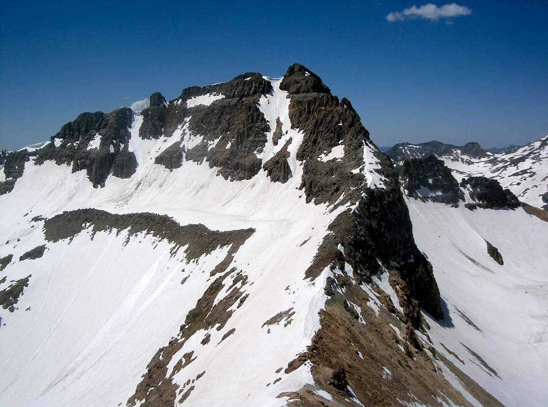
Vermilion Peak from Golden Horn's Southwest Ridge
Route Options
Southeast Ridge - Class 2+, 10.2 miles and ~4,100 feet elevation gain
The southeast ridge route is the standard & easiest route on Vermilion Peak. See red annotation on map below.
Vermilion Dollar Couloir - Class 3, 10 miles, ~4,100 feet elevation gain
The Vermilion Dollar Couloir ascends the aesthetically-pleasing couloir on the east face of Vermilion Peak. See black annotation on map below.
Northeast Ridge - Class 3, 10 miles, ~4,100 feet elevation gain
The northeast ridge route is commonly used when combining ascents of Vermilion Peak and Golden Horn and also provides a Class 3 alternative to the standard route. See blue annotation below. Starting at the S. Mineral Creek Trailhead (see Getting There section), follow the approach to 12,900' in Ice Lake Basin (see green annotation on map below). Continue west for 0.3 miles to 13,060', then climb a southwest-facing ramp to 13,300'. Then find an old trail that leads north through the cliffs reaching the northeast ridge of Vermilion Peak at 13,400'. Scramble southwest to the summit. At 13,600', bypass a tower on the west side of the ridge (Class 3). At a vertical step at 13,700', traverse south 100 yards on a ledge on the east side of the ridge until you reach the upper 120' of the Vermilion Dollar Couloir. Climb the couloir to where it joins the southeast ridge. Continue 100' to the summit (Class 2+).
Southwest Basin - Class 3, 10.2 miles, ~4100 feet of elevation gain
The southwest basin route is the only route listed here that originates at the San Miguel Trailhead on the west side of the peak. This route includes an ascent of nearby Fuller Peak. See orange annotation map below.
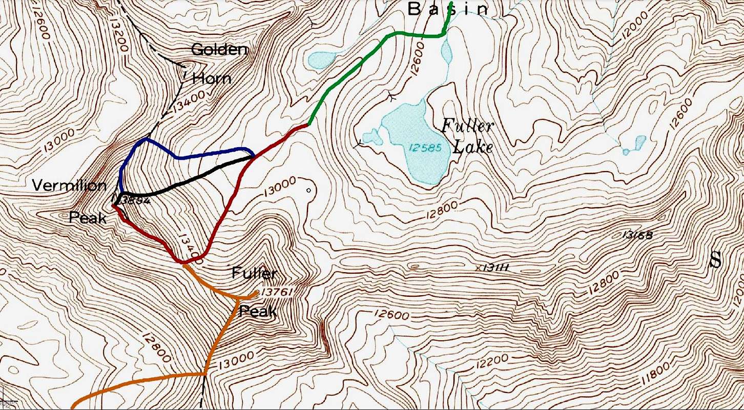
Green: Ice Lake Approach - Class 1, Red: SE Ridge - Class 2+, Black: Vermilion Dollar Couloir - Class 3, Blue: NE Ridge - Class 3, Orange: SW Basin - Class 3
Getting There
South Mineral Creek Trailhead (East Side):
The easiest way to get to Vermilion Peak, is from Silverton, Colorado. Follow US 550 north towards from the US 550-110 intersection for 2.0 miles until you see the turnoff for the South Mineral Campground. Take this turn (left) and follow the good quality dirt road for another 3-4 miles until you arrive at the South Mineral Campground. There is parking on the right side of the road and this is the trailhead and the start of the approach to Ice Lakes Basin. Four wheel drive vehicles can shorten the approach by making a right off of the South Mineral Road towards Clear Lake and park at the first switchback. An unmarked trail goes west to intersect the Ice Lakes Trail. Near the intersection is a waterfall crossing which can be difficult in early season. This approach shaves 1.8 miles and 540 vertical feet off the roundtrip distance and elevation gain. Once in Ice Lakes Basin there are several routes to choose from. Everything from class 2+ to steep snow climbs.
San Miguel Trailhead (West Side):
If you choose to approach Vermilion Peak from the west, consider using the Lake Fork San Miguel Trailhead, which is at 10,720'. To reach the trailhead from the north, drive 10.1 miles on CO 145 from Society Turn just west of Telluride, Colorado, or if you are approaching from the south, drive 1.9 miles north on CO 145 from Lizard Head Pass. Turn east onto N. Trout Lake Road (Forest Service 626) and drive for an additional 1.7 miles. Turn left onto Hidden Lake Road (Forest Service 627) and drive another 2.6 miles to the trailhead.
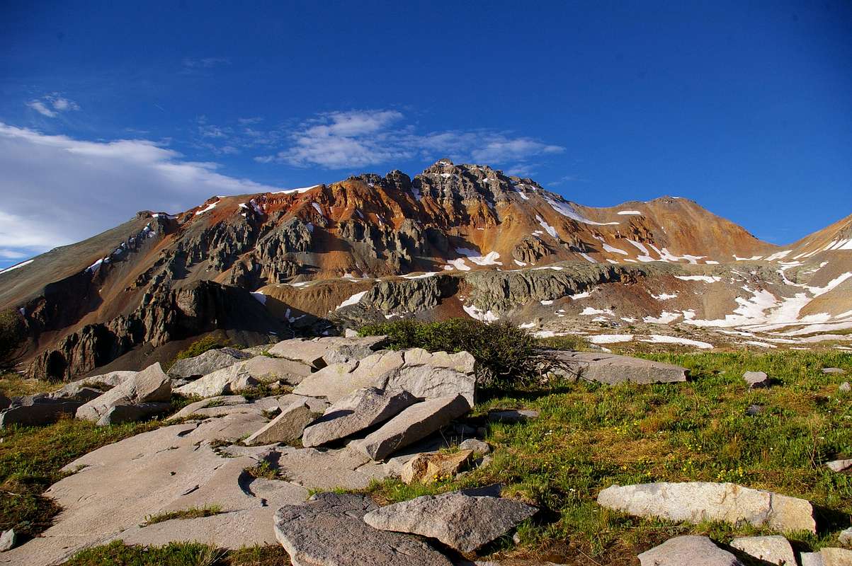
Vermilion Peak. Photo: BigRob
Red Tape
Vermilion Peak is located within the the San Juan National Forest (970-247-4874) and there are currently no permits required. There is ample parking at the South Mineral campground on the east side of the peak. The 4x4 parking on the road to Clear Lake, also on the east side, is limited.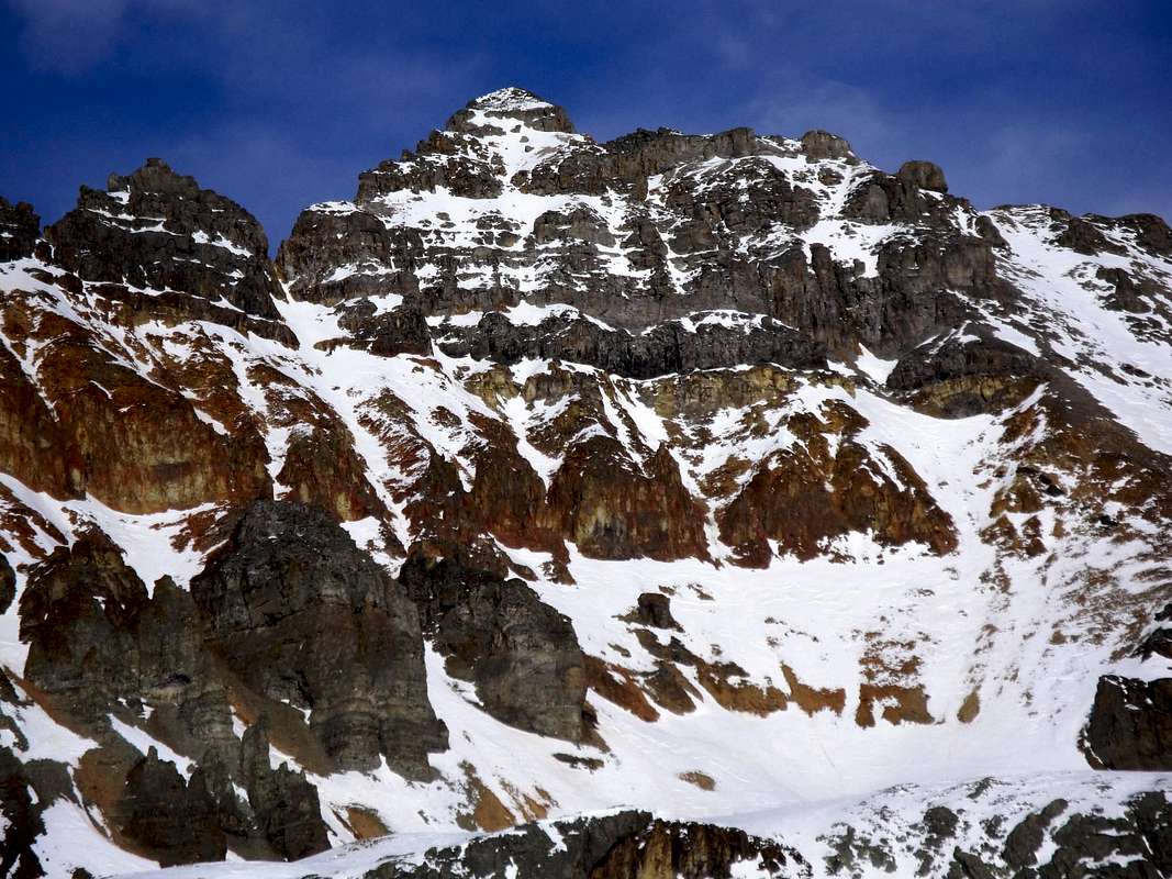
Vermilion Peak. Photo: BigRob
When To Climb
Summer months are generally the best. Ice Lakes Basin holds snow late into the year and sometimes year round. So be prepared. Some routes (i.e. Vermilion Dollar Couloir) are safer to climb when still frozen, minimizing the exposure to rockfall, so hit those earlier in the season.Camping & Other Lodging
There are many good campsites along the South Mineral Road and good backpacking destinations in Ice Lakes Basin.Silverton also has a variety of hotels, motels, and inns that would all serve well as a starting place for your climb. Check out www.silvertoncolorado.com for more detailing information on availability and rates.
Maps & Literature
Maps:
1. USGS: Ophir 7.5 minute quadrangle
2. USFS: San Juan National Forest, Uncompahgre National Forest
3. Trails Illustrated: Map #141 Telluride/Silverton/Ouray/Lake City
3. Trails Illustrated: Map #141 Telluride/Silverton/Ouray/Lake City
Woodie Hopper - Sep 21, 2020 8:22 am - Voted 10/10
West route from San Miguel THThere is currently a fairly well established climber’s trail that bypasses Fuller’s summit pyramid.