
-
 9573 Hits
-
 87.76% Score
-
 25 Votes
|
|
Route |
|---|---|
|
|
61.65030°N / 8.55812°E |
|
|
Mountaineering |
|
|
Summer |
|
|
Most of a day |
|
|
Alpine F |
|
|
Overview
Geographical classification: The Scandes > Jotunheimen > Glittertind - Glittertinden > Glittertinden East Flank Normal Route
Glittertinden East Flank Normal Route
Glittertinden, the official name, or Glittertind, is a charming ice-capped peak located in the municipality of Lom and belonging to the magnificent Jotunheimen massif, the highest and most famous mountain area in Norway and in the whole Scandinavia, between Oppland and Sogn og Fjordane counties, South-Central Norway. Glittertind is one of the 198 twothousanders of Norway and the second highest peak of the country, after Galdhøpiggen. The summit of Glittertind was reached for the first time in 1841 by Harald Nicolai Storm Wergeland and Hans Sletten (Norway). Glittertinden and Galdhøppigen had competed for the title as the highest mountain in Norway, as measurements showed that Glittertind was a handful of meters higher than Galdhøpiggen (2469 m above sea level). Galdhøpiggen summit is mainly rocky, while Glittertind summit is covered by a glacier; this summit glacier has shrunk in recent years, so finally the dispute has been settled in favour of Galdhøpiggen.
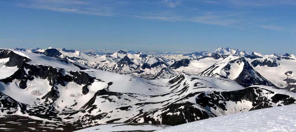
The Jotunheimen area seen from the summit of Glittertinden
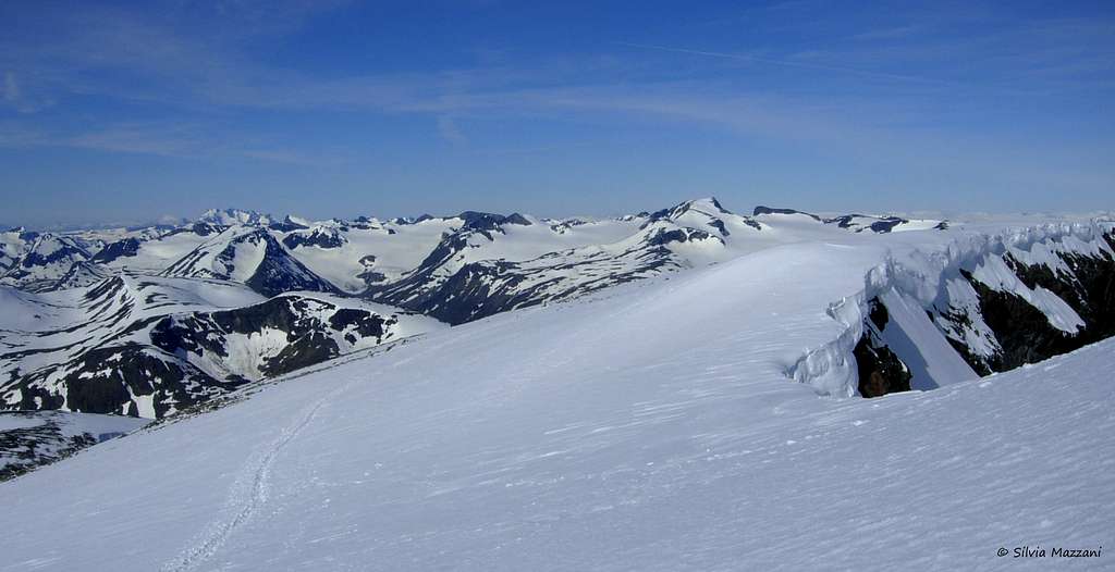
There are two Normal routes getting easily to the summit of Glittertind: the Western route, starting from Spiterstulen, is a 1300 meters climb, while the Eastern one is a 1100 meters climb starting from the Glitterheim Hut, located within the borders of the Jotunheimen National Park . This latter is an easy and magnificent ascent, allowing to reach the top and enjoy an absolutely stunning view towards the glaciers surrounding this mountain and the peaks stretching to the horizon.
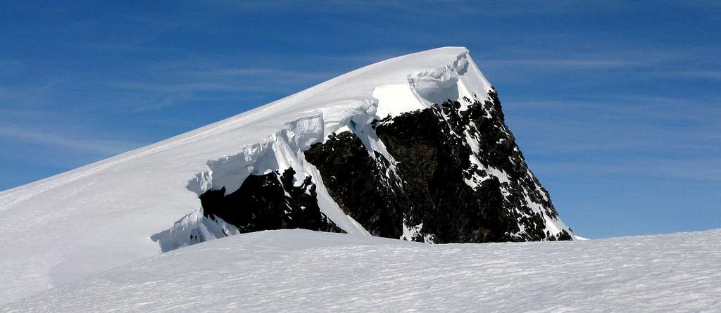
Top of Glittertinden seen from East Ridge
Getting There
Road access to Lom
From Oslo follow the E6 to Hamar, Lillehammer and Otta, here turn to left following the Road 15 toward Vagamo and Lom, the main center of the Oppdal county. This small and lively town is the best starting point to climb Glittertind and the gate to the Jotunheimen National Park. Approximately 90% of the municipality of Lom is covered by glaciers and mountains, with Galdøppigen and Glittertind being the two well known landmarks. Lom has several accommodation, camping with cabin, hotels, here you can visit the 850 years old Lom Stave Church (Stavkyrkje), one of the largest one in Norway.


From Lom to Glitterheim Gate
From Lom skirt the Vågåvatnet reaching Garmo and here leave the main road and turn to right, reaching the starting of a toll-road (currently NOK 20). You pay in an envelope, so carry enough in coins. The road is running about 23 km through a superb landscape in the Veodalen valley, passing a couple of gates on the way and reaching the gate at the Jotunheimen National Park border, near an arch where the road is closed. Parking area.


Another approach way is following the highway 51 (from Fagernes to Vågåvatnet), and exit West towards Glitterheim, just before Randsverk. The exit is marked by a white sign. From here you can take the same 23 km toll-road as for the previous description.
Walking approach to the Glitterheim Hut
Follow by walking the remaining 7 Km dirty road getting to the Glitterheim Hut. It' possible to rent a MTB near the parking and at the lodge when coming back.
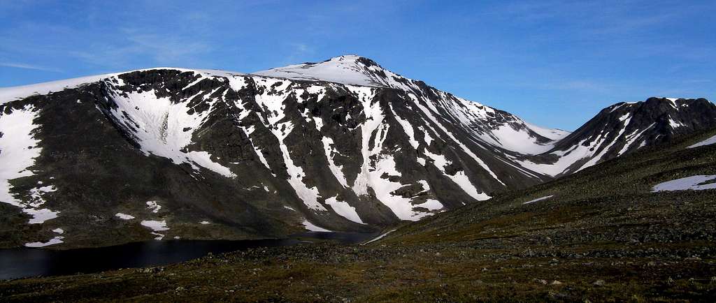
View of Steinbuvatnet Lake near Glitterheim
Glittertinden East Flank Normal Route
Glittertinden East Flank Normal Route
Summit altitude: 2464 m
Difficulty: Alpine F
Difference in level: 1080 m
Exposure: East
Starting point: Glitterheim Lodge m 1384
A satisfactory and easy ascent along snow-slopes, the upper glacier and the aesthetical summit ridge. The elevation gain is gentle all the way. The route up to Glittertinden is "T" marked.


From Glitterheim take on the right (North-West) a track – wooden signposts – following a North-West direction and rising at first along grassy slopes and stones, then through snow-fields. Very soon you can see Glittertinden summit up to the left. The climb gets to the starting point of the glacier, where the direction goes towards West.


Climb the gentle ice-slope slanting left, reaching the East ridge of the mountain. Follow the ridge taking a superb view over the summit, pass the false summit skirting it on the South side and follow the last ridge bordered by huge corniches to the summit.


Descent: reversing the route
Essential Gear
Axe and crampons may be required when the final slopes are iced, so carry ice gear to be on the safe side.
Red Tape

There are no fees or permits needed to climb Glittertinden. Be aware that on a summer weekend the parking can be absolutely full. The mountain is lying within the superb Jotunheimen National Park , established in 1980, covering an area of 1140 km² and including the 27 highest peaks in Norway.


Jotunheimen is located between Oppland and Sogn og Fjordane counties and it's bordered by the great lake called Vågåvatnet, the valleys of Bøverdalen and Leirdalen and the road No. 55 (the mytical Sognefjellveg) to the N and NW, by the Road 51 to the East, by Bygdin, Tyin and Årdal to the South and by the mountain road between Årdal and Turtagrø to the West.
Hut
- Glitterheim Lodge 1384 m
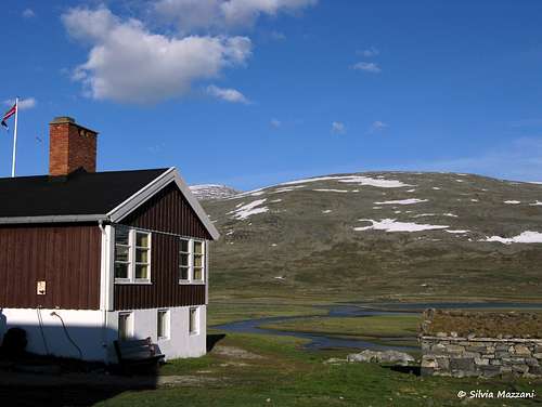
Situation: foot of Glittertinden
Open: from June, 20th to September, 20th
Size: 137 persons
Owner: D.N.T. Den Norske Turistforening
Phone 61 23 18 33
E-mail: gl-heim@online.no


Glitterheim is a mountain lodge owned by the Norwegian Mountain Touring Association, at the foot of Glittertinden. It was designed by architect Hjalmar Welhaven and built in 1901.
When to climb
Best period to climb Glittertind goes from the end of June to the end of August
Meteo

Guidebooks and maps
Guidebooks


- "Walks and scrambles in Norway" - Anthony Dyer - John Baddeley - Ian H. Robertson - Hiking, Scrambling and Mountaineering in Norway, an English guidebook covering Jotuheimen and several other areas in the Scandes Ripping Yarns 2006
- "Opptur Jotunheimen" - Finn Loftesnes - 125 selected itinerary on Jotunheimen - Selja Forlag 2009
Maps
1618 III Glittertinden Norge 1:50 000 (Norway 1:50 000). This is the main series of 727 topographical maps in 1:50 000 scale that cover the entire mainland area of Norway and proximate islands.
External Links
- Scandinavian Mountains
- Jotunheimen
- D.N.T. Den Norske Turistforening