


-
 6695 Hits
-
 81.18% Score
-
 13 Votes
|
|
Mountain/Rock |
|---|---|
|
|
45.72160°N / 7.49652°E |
|
|
Fénis Municipality (Mont Corquet Subgroup) |
|
|
Hiking |
|
|
Summer |
|
|
4541 ft / 1384 m |
|
|
Note
La montagna chiama i suoi figli, ed essi rispondono fedelmente al suo appello… Osvaldo Cardellina, Diario alpinistico, 1964-65 Page texts: @ OsvaldoCardellina "Osva", passed away on May 2, 2022. Page owners: Christian Cardellina e Osvaldo Cardellina. Any updates from September 12, 2022: Antonio Giani, page administrator, friend and climbing companion. Testi della pagina: @ OsvaldoCardellina "Osva", scomparso il 2 maggio 2022. Proprietari pagina: Christian Cardellina e Osvaldo Cardellina. Eventuali aggiornamenti dal 12 settembre 2022: Antonio Giani, amministratore della pagina, amico e compagno di salite. |
Overview
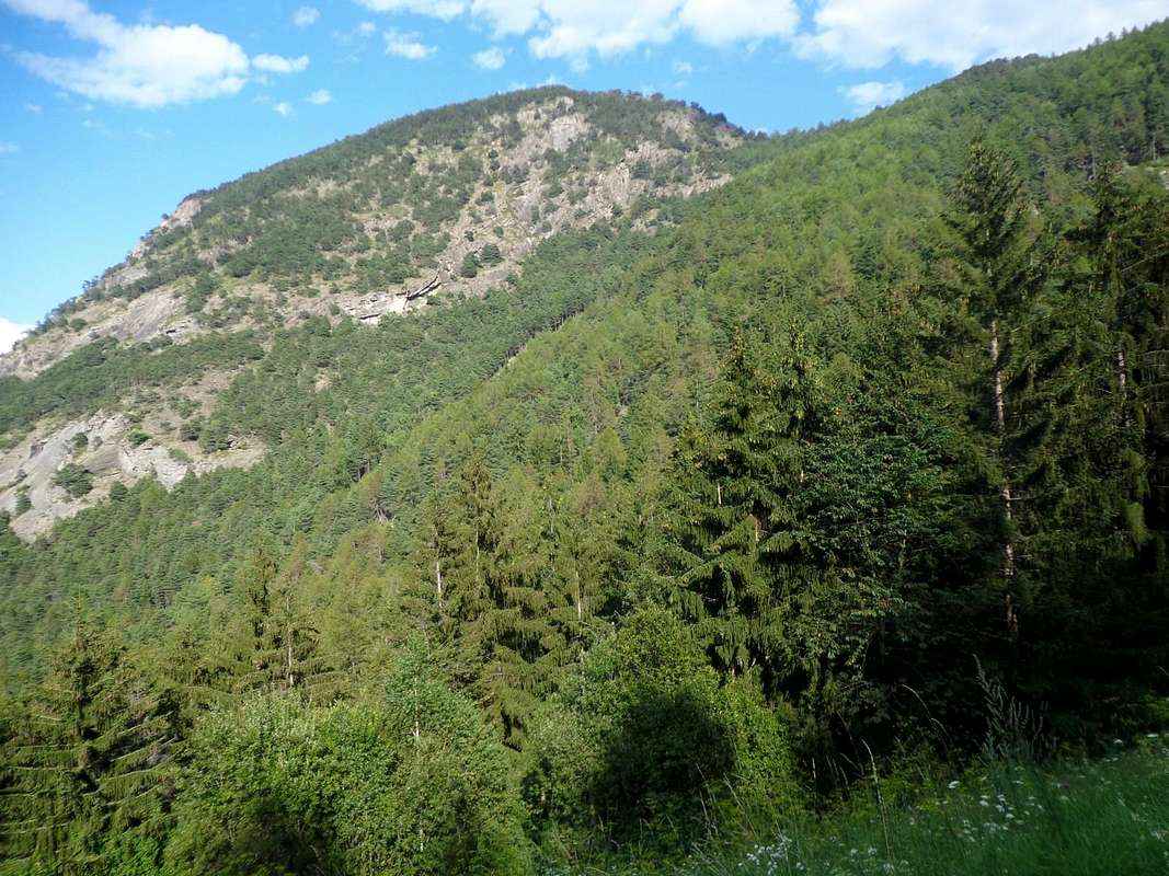
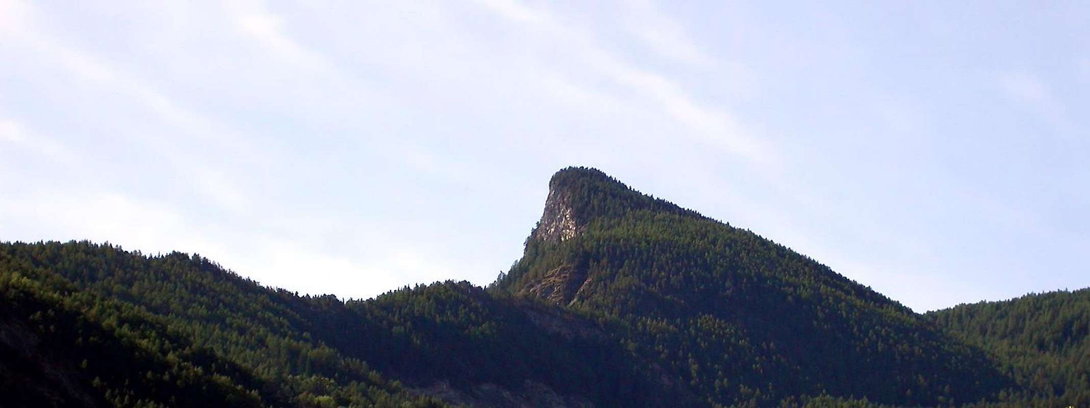
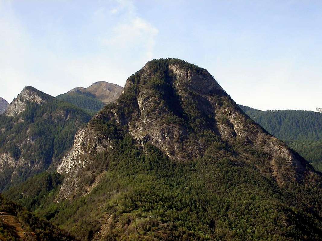
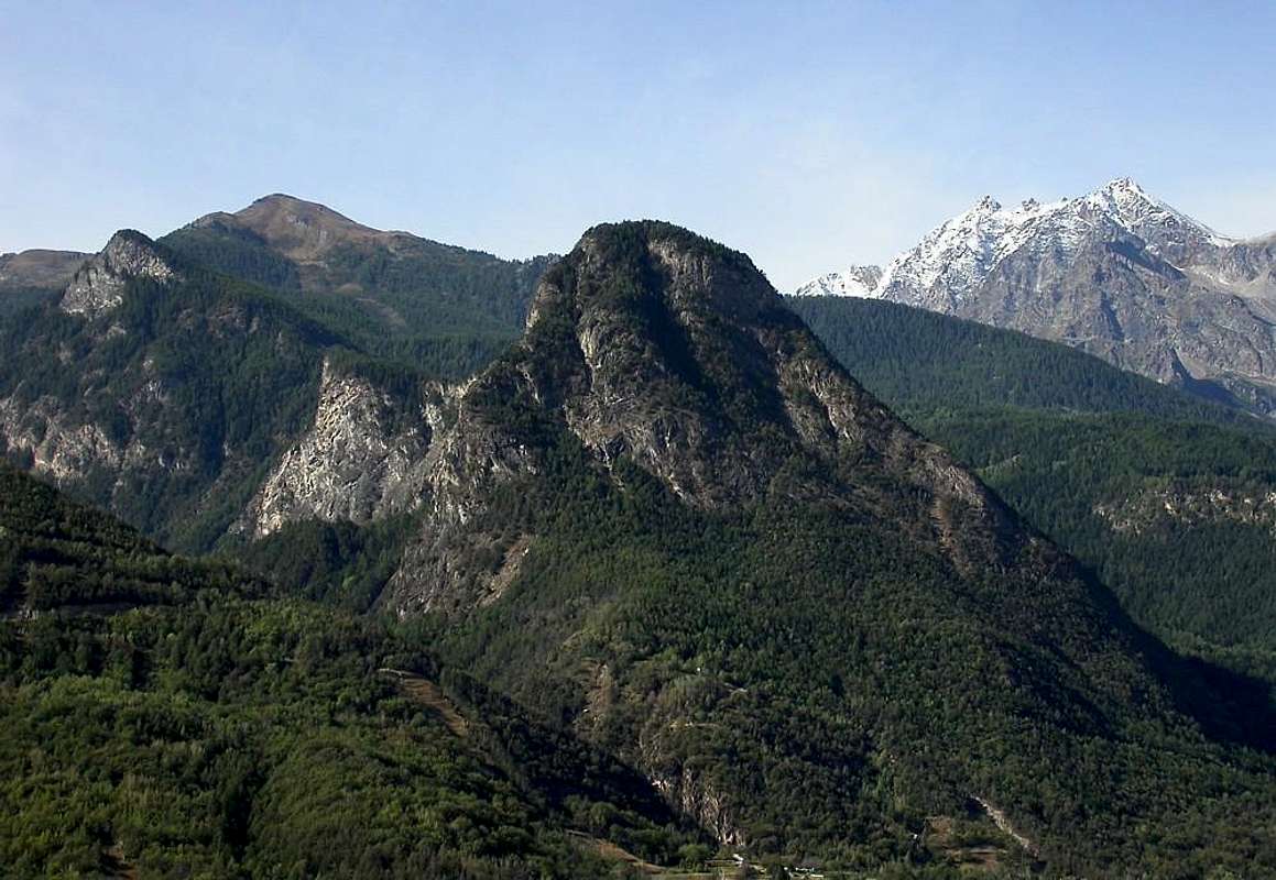
This mountain, but not excessive height from the forms clearly in evidence, is placed at the end of the very long ridge, starting from Punta Tersiva (3.515m) arrives to the Central Valley of the River Dora Baltea, above the little Town of Fénis (very famous and splendid Medieval Castle) at the entrance of the vallon with same placename. It serves as the watershed between this and the adjacent (to the West), Valley of Saint Marcel, this splits after Mount Corquet (2.527m): a branch facing North-northeast gets up in Torrasse also Tower and then finally down to the Mount Saint Julien, while the second goes more towards the North-northwest to Mount Roux and the Mines of Servette, near, from East to West, Villages of Petit and Les Grandes Drouges and the Alps and Pouria Vargney on the private road, which alleges the Reserve Turati. Between these two short watershed lies small the Vallon of the Pieiller, divided by the Municipality of Saint Marcel from Torrent Morgnet(t)z, while the portion to the East of this is the real Pieiller leaning against the Mount Saint Julien and fades into the end and wooded against Mount The Torrasse (1.854m), also clearly visible from the central valley. Finally, the two parties shall meet up at Alpage Prapremier (2.011m) at the base of Corquet where, shortly afterwards, ending the boundaries between the two municipalities. The sector of Mount Saint Julien is therefore one further East, where the mountain comes with a great forest that covers up to the Summit, interspersed with steep rock bands of blackish or whitish (not uncommon to see an eagle circling against the same). The North Side assumes a more impressive with large rock outcrops that fit steeply in the wood, while to the East, or on Vallon Fénis, rushes with a spectacular cliff of over 500 meters above the Torrent of Clavalité. Of elementary uphill along a path half is suitable for trips with children, observing due caution, especially in the descent from the Sanctuary to the Hermitage, short but exposed even if well protected by fences made of wood or stone walls, on the left coming down. A much longer route, path in the old days for Religious Processions, starts from the Village of Le Perron (582m) with route n° 10 or with other variants nearby, in which case the trip is transformed by Tourist in Hiking, becoming the difference to be made from 170/80 meters and with the ascent from the Hermitage around 300 in total, but the 800/900 meters. Great views of the Central Valley for over Dora the City of Aosta towards Courmayeur (in the distance the Mount Blanc Mountain Chain) until the middle valley towards Mount Zerbion above Chatillon and Saint Vincent Towns; glance magnificent, uphill, the nearby Atlas of Roèses, while downhill front stands at the height of the High Comba Tersiva, the pyramid of Tersiva offering its white Wall North-Northeast.
 |
Questa montagna, di non eccessiva altezza ma dalle forme nettamente evidenti, é collocata al termine della lunghissima cresta che, partendo dalla Punta Tersiva (3.515 m) arriva insino alla Valle Centrale del Fiume Dora Baltea, sopra la Cittadina di Fénis all'imbocco dell'omonima valle (famosissimo e splendido Castello Medioevale). Funge da spartiacque tra questa e l'attiguo (ad Ovest) Vallone di Saint Marcel; questo si sdoppia dopo il Mont Corquet (2.527 m): un ramo rivolto a Nord-nordest si rialza nella Torrasse per poi definitivamente scendere al Mont Saint Julien, mentre un secondo scende più verso Nord-nordovest fino al Mont Roux ed alle Miniere di Servette, nei pressi dei, da Est ad Ovest, Villaggi di Petit e Les Grandes Drouges e delle Alpi Pouria e Vargney sulla strada poderale, adducente alla Riserva Turati. Tra questi due brevi spartiacque s'adagia il Vallone del Pieiller, diviso dal Comune di Saint Marcel dal Torrent La Morgnet(t)az; la parte ad Oriente di questi costituisce il vero e proprio Vallone del Pieiller che s'appoggia contro il Mont Saint Julien e si smorza nella parte terminale e boschiva contro il Mont La Torrasse (1.854 m), anche questo ben in vista dalla valle centrale. Infine le due parti si riuniscono in alto presso l'Alpe Prapremier (2.011 m), alla base del Corquet ove, poc'oltre, terminano i confini tra i due comuni. Il settore del Mont Saint Julien risulta quindi quello più ad Est, dove il monte si presenta con grande foresta ricoprentelo fino alla Sommità, inframmezzato da ripide fasce rocciose di color nerastro o biancastro (non raro veder volteggiar l'aquila in contrasto alle medesime). Dal lato Settentrionale assume una dimensione più imponente con costoloni rocciosi inserentisi ripidamente nella foresta e poi nel bosco, mentre ad Est, ovvero sulla Vallone di Fénis, precipita con spettacolare parete rocciosa di oltre 500 metri sopra il Torrent de Clavalité. Di elementare salita lungo un sentiero a mezza costa é adatto a gite anche con bambini, osservando le dovute cautele, soprattutto nella discesa dal Santuario verso l'Eremo, breve ma esposta pur se ben protetta da staccionata in legno o muretti a secco, sulla sinistra scendendo. Un itinerario ben più lungo, percorso nei tempi andati per le Processioni Religiose, parte dalla località di Le Perron (582 m) con sentiero n° 10 o con altre viciniore varianti; in questo caso la gita si tramuta da Turistica in Escursionistica, divenendo il dislivello da compiere da 170/80 metri circa e con la risalita dall'Eremitaggio intorno ai 300 complessivi, bensì di 800/900 metri. Grandi viste sulla Valle Centrale della Dora da oltre la Città di Aosta in direzione di Courmayeur (in lontananza la Catena del Monte Bianco) fino alla media valle verso il Monte Zerbion, sopra Chatillon e Saint Vincent; colpo d'occhio magnifico, in salita, sulla vicina Catena delle Roèses, mentre in discesa frontalmente troneggia, al colmo dell'Alta Comba Tersiva, la piramide della Tersiva offrendo la sua candida Parete Nord-nordest.
The famous ...: "But You believe in this Legend, or they are all tall tales & fables of Nonnino?", by Little Grandpa
The Légends
 |
San Giuliano, according to the register of the parish in 1909, already existed in the Year 1650. Three documents, however, show that existed long before: an act from 1327, a report of the pastoral visits, dated November 24, 1441, the third, finally, is a very relevant document dated 30 March 1537, with specific reference to the Hermitage. For the Legend, the same was constructed in the identical position in which occurred the Martyrdom of St. Julian, a Christian prisoner of the Romans who forced him to work together with other slaves in the Mines of Misérègne. It seems that, because his Faith, who warned preaching among themselves and to the soldiery, they have led to the cliff throwing him downstairs. His friends, for a perpetual memory, built a church in the place of the event. It seems, too, that his mortal remains are walled up behind the Altar. An ancient custom makes the first Thursday of the month of May, hold a Procession to the Mount, where comes a Mass celebrated. In the hermitage lived since 1865 a Hermit, who survived asking Alms in the Village and in the Parish of Fénis. After a couple of centuries, the chapel was built in honor of the Saint. Subsequently, the Municipality of Fénis granted to another Hermit to settle here: it was 1777, when Champier Jean-Pierre de Mathieur was allowed to dwell. Born in Ollomont in Valpelline May 12, 1751, was orphaned as a child, finding hospitality at the Convent of the Capuchins in Aosta Town, the Freiburg and others, always in Switzerland. The hermit stood Champier Fénis long and then retired to his native country, where he made new home, always as a hermit on the left of the chapel of Notre-Dame des Neiges sur les Vignettes. He died before 1830. The last hermit who lived in Saint Julien was Jean-Pantaleon Lavy, who was born in '30, died December 14th, 1864. A second Legend, reported by Lino Fornelli in "Guide Emilius Rosa dei Banchi Park M.Avic", by Giulio Berutto & Lino Fornelli and Edited from C.A.I./T.C.I. in March 2005, pages 176/7, tells instead of a Pastor thrown from the top, after a quarrel, and from other pastors who had miraculously saved "landing" after a terrible flight, on that rocky ledge, where was built the Hermitage " ... Every year on June 5 is celebrated the Mass for the feast of the Holy ...". Another Rumo(u)r with piece of Gossip is the home of the Hermit instead coincide with the ruin which meets immediately began the descent, after the Shrine of Saint Gratus. And, again, be noted that the Charter gives the Italian Military Geographic Institute (I.G.M.) name as "Santa Giuliana", or female. The pronunciation in French leaves little difference between Julien and Julien(ne) with the final "ne" almost nose, an ear that little educated and sophisticated in the knowledge of the language transalpine can easily "be taken by Deception" and misrepresent. Or, and finally, with a bit of Fantasy, we say, has not been the case for a so-called "Witch" which, in the Middle Ages, to escape the Stake, here it is repaired? The choice is Yours ...
 |
San Giuliano, come da registro delle parrocchie del 1909, era in esistenza già nell'Anno 1650. Tre documenti, tuttavia, dimostrano che sussisteva da molto tempo anteriore: un atto del 1327; un verbale delle visite pastorali, datato 24 novembre 1441; il terzo, infine, è un documento alquanto pertinente datato 30 marzo 1537, con preciso riferimento all'Eremo. Per la Leggenda, lo stesso fu costruito nell'identica posizione nella quale avvenne il Martirio di San Giuliano, un Cristiano prigioniero dei Romani che lo obbligavano al lavoro insieme ad altri Schiavi nella Miniere di Misérègne. Causa la sua Fede, che promulgava predicando tra gli stessi nonché alla soldataglia, sembra l'abbian portato al dirupo gettandolo dabbasso. I suoi amici, a perenne ricordo, costruiron una chiesetta nel luogo dell'evento. Par, inoltre, che le sue spoglie mortali sian murate tergo all'Altare. Un'antica Usanza fa sì che nel primo giovedì del mese di maggio si tenga una Processione al Monte, ove vien celebrata la Santa Messa. Nell'Eremo viveva sin al 1865 un Eremita, che sopravviveva chiedendo Elemosine nel Villaggio ed alla Parrocchia di Fénis. Trascorsi un paio di Secoli, fu costruita la Cappella in onore del Santo. Successivamente il Comune di Fénis concesse ad un altro Eremita di stabilirsi qui: era il 1777, quando Champier Jean-Mathieur de Pierre ottenne il permesso di prender dimora. Nato a Ollomont in Valpelline il 12 Maggio 1751, rimase orfano fin da piccolo, trovando ospitalità presso il Convento dei Cappuccini di Aosta, quello di Friburgo ed altri, sempre in Isvizzera. L'eremita Champier permase in Fénis a lungo onde ritirarsi nel suo paese natale, ove si fece nuova casa, sempre da eremita, sulla sinistra della cappella di Notre-Dame des Neiges sur les Vignettes. Morì prima del 1830. L'ultimo Eremita vissuto a Saint Julien fu Jean-Pantaléon Lavy, che, nato nel '30, morì il 14 dicembre 1864. Una seconda Leggenda, riportata da Lino Fornelli in "Guida Emilius Rosa dei Banchi Parco del M.Avic", di Giulio Berutto e Lino Fornelli, Editato da C.A.I./T.C.I. nel 2005. pagine 176/7, narra invece di un Pastore gettato dall'alto, dopo una lite, da altri pastori e che si era, miracolosamente, salvato "atterrando", dopo un volo immane, su quella cengia rocciosa, dove é stato costruito l'Eremo: " ... Ogni anno il 5 di giugno vi si celebra la Messa per la festa del Santo ...". N'altra Diceria fa invece coincider l'abitazione dell'Eremita col rudere che si incontra subito iniziata la discesa, dopo il Santuario di San Grato. Ed, ancora, da osservar che la Carta dell'Istituto Geografico Militare Italiano (I.G.M.) riporta il toponimo come "Santa Giuliana", ovvero al femminile. La pronuncia in francese lascia poca differenza tra Julien o Julienne con il "ne" finale quasi nasale, tal che un'orecchio poco educato e sofisticato nella conoscenza del linguaggio transalpino può facilmente "esser preso d'Inganno" e travisar. Od oppure, infine e con un pò di Fantasia, diciam noi, non sarà stata per caso 'na cosiddetta "Strega" che, nel Medio Evo, per sfuggir al Rogo, qui s'é riparata? A Voi la scelta ...
From the Municipal Road in Pieiller's Vallon to fork of Le Coteau, by Osw
The Upper Alpage of PRAPREMIER (2.011m), between Fénis/Saint Marcel Municipalities, by emilius
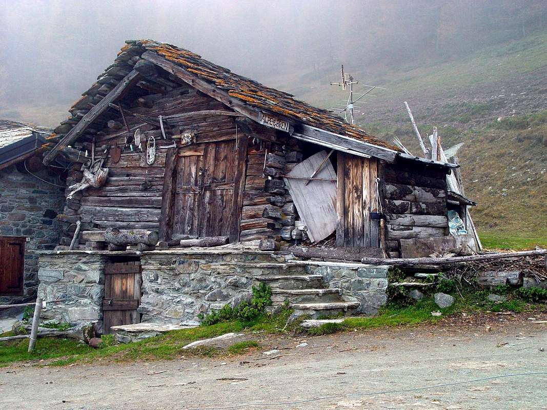
The "Exotic" Alpage of BREN (1.961m), by emilius
Descending with Main Road fro Les Druges Area to Saint Marcel Municipality, by emilius
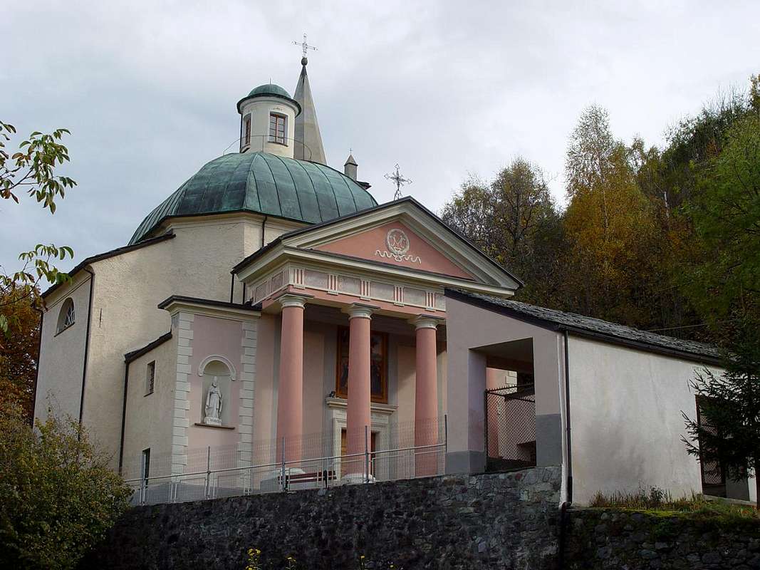
The renowned PLOUT SANCTUARY (968m), by emilius
The WEST SLOPE or Standard Route from Le Coteau into Pieiller's Vallon, by Osw
Getting There Road Itineraries from Fénis & to Saint Marcel
 |
From the Village of Fénis, accessible from Highway n°26 crossing the bridge over the Dora Baltea Stream, just after the Country of Nus (output Motorways A7), arriving at the junction 539 meters, and immediately after the field of Football, leave the roundabout to the left on the same (large signals), and go up to the Chief Lieu. Following the signs in color marron "Saint Julien" and, still leaving the Municipal Road to the East to Barche Hamlet and towards Clavalité's Vallon satisfy the signs for the "Vallon of Pieiller", a tarmac road dates back to the South, starting between the Villages of Le Perron (582m) and Pommier (614m), and through road bends that door, through the woods, to the small Village of Le Boit-du Chat (695m) and the subsequent of Champlan. After four more through the hairpin road nearby the Torrent Bioley and goes West towards the basin left its course, always with tight bends reaches The Pieiller-de-Sermaz (1.075m) and then Maison Longue (1.112m) and The Plany (1.174m), with a last bend to the East toward the Morgettaz reach the junction, with small parking lot on the floor, for the little semi-abandoned Village of Le Coteau (1.234m). VARIOUS REMARKS
 |
The carriage, which then continues over and again crosses the Torrent de Bioley reaching the other side, with a wide circle first and then North-northwest to West-southwest, reach a junction just beyond the Village Champremier (1.383m), connecting to the Municipal Road leading up to Saint Marcel to the Conch of The Druges thus combining the "viability" in the upper area between these two municipalities. Please note that the path is formed by a narrow road with many hairpin bends, for which reason it is good thing to pay attention. This Road Connection also allows power to vary the same trip, and after the climb to Saint Julien, such as going to Area Pic Nic Les Druges with the Various Opportunities:
a) - Stay with the same modest sum payment (fountain, benches and tables in wood, stone barbecue, toilets);
b) - visit the Sites of the Mines of Copper and Iron Servette (from the nearby location of Furnace, now in ruins, the tops of which are accessed through marked trails and a General Map departure (Entrances, Houses and the remains of the Miners of large Ropeways wood for the transport of Ore);
c) - from Les Druges High (1.567m) ascending with the route n° 14 starting at the fountain with adjoining gorgeous little "Rascard" wood and lift the nearby Chapel of Saint Bernard, from this, depending on your choice , you can continue up to the summer Pastures of Fontanafreida (around 1.800 meters), Bren (1.961 m; fountain) and finally the last of Prapremier or Praz-Premier (2.011m), right on the border with the Municipality of Fénis. Regarding the descent, in case of extension of the excursion to the Area of Druges, it is convenient from the junction of the road on the right Champremier abandon climbed and get off at Saint Marcel through the Regional Road, in such a way passing from the "Inn of the Hell", Viplana, Ronc, Sazailland and Seissogne (1.066m; beautiful wooden mill) you will reach the Village Plout with its very famous Sanctuary of 1640, but existing as a niche, since 1200, dedicated to "Notre Dame des Hermites" (968 m; beautiful "Via Crucis" outside on the arcade, which depicts the "Fifteen Mysteries of the Rosary" by Painter of Asti in 1854). From Plout also Plou continue to Réan, Mezéin (793 m, 300 m before, turn right for Fénis), Jayer, Moulin and Saint Marcel (Castle Location Paquier; 609m), and finally, passing under the Motorway and crossing the bridge over the Dora Baltea near the ancient Foundry Copper (547m) you get to SS.26. Combining it with the ascent of Saint Julien from Fénis through Pieiller Walloon, is Fantastic Hiking Tour, scenic, cultural and instructive.
 |
Dal Paese di Fénis, raggiungibile dalla Strada Statale n°26 attraversando il ponte sulla Dora Baltea, subito dopo il Paese di Nus (uscita Autostrada A7), arrivando al bivio 539 metri; subito dopo il campo di Calcio, lasciare a sinistra la rotonda sulla medesima (ampie segnalazioni), e salire verso il Capoluogo. Seguendo i cartelli in color marron "Saint Julien" e, lasciando ancora ad Est la strada Comunale per la Frazione Barche e la Clavalité, assecondare le indicazioni per il "Vallone del Pieiller"; una strada in asfalto risale verso Mezzogiorno, partendo tra le Frazioni di Le Perron (582 m) e Pommier (614 m), e tramite stretti tornanti si porta, in mezzo al bosco, al piccolo Villaggio di Le-Boit du Chat (695 m) ed al successivo di Champlan. Dopo altri quattro tornanti attraversa il Torrent Bioley e si porta ad Ovest verso il suo corso idrografico sinistro; sempre con stretti tornanti raggiunge Le Pieiller-de-Sermaz (1.075 m) e successivamente Maison Longue (1.112 m) e Le Plany (1.174 m); con un ultimo tornante ad Est verso la Morgettaz raggiunge il bivio, con ridotto parcheggio in terra, per il piccolo Villaggio semi abbandonato di Le Coteau (1.234 m). ANNOTAZIONI VARIE
 |
La carrozzabile, poi continuante oltre e attraversante nuovamente il Torrent de Bioley portandosi sull'altra sponda, con un largo giro dapprima a Nord-nordovest e quindi ad Ovest-sudovest, raggiunge un bivio appena oltre il Villaggio di Champremier (1.383 m), collegandosi alla Strada Comunale risalente da Saint Marcel verso la Conca delle Druges unendo così la "viabilità" nella zona alta tra questi due comuni. Da segnalare che il percorso é formato da stretta strada con molti tornanti a gomito, per il qual motivo é cosa buona prestar attenzione. Questa Strada di Collegamento permette, inoltre, di poter variar la gita medesima e, dopo la salita al Saint Julien, ad esempio salire All'Area Pic Nic di Les Druges con Varie Possibilità:
a) - sostare alla medesima con modica cifra di pagamento (fontana, panche e tavoli in legno, barbecue in pietra, servizi igienici);
b) - visitare i Siti delle Miniere di Rame e Ferro di Servette (dalla vicina Località di Fornace, ormai in rovina, alle parti superiori alle quali s'accede tramite sentieri segnalati ed una Mappa Generale alla partenza (Imbocchi, Case dei Minatori e resti delle grandi Teleferiche in legno per il trasporto del Minerale);
c) - da Les Druges Alte (1.567 m) salire con il sentiero n° 14 partendo alla fontana con attiguo splendido e piccolo "Rascard" in legno e risalita alla vicina Cappelletta di San Bernardo; da questa, a secondo della vostra scelta, potete continuare fin agli Alpeggi di Fontanafreida (1.800 metri circa), Bren (1.961 m) ed infine all'ultimo di Prapremier o Praz-Premier (2.011 m), proprio al confine col Comune di Fénis. Per quanto concerne la discesa, in caso di prolungamento della gita insino l'Area delle Druges, conviene dal bivio di Champremier abbandonare sulla destra la strada percorsa in salita e discendere in Saint Marcel con la Strada Regionale; in siffatta maniera passando dalla "Locanda del Diavolo, Viplana, Ronc, Sazailland e Seissogne (1.066m; bel mulino in legno) si raggiunge il Villaggio di Plout con il suo famosissimo Santuario del 1640, ma esistente, come nicchia, già dal 1200, dedicato a "Notre Dame des Hermites" (968 m; splendida "Via Crucis" all'esterno nel porticato, che raffigura i "Quindici Misteri del Rosario" ad opera di Pittore Astigiano nel 1854). Da Plout o Plou continuare per Réan, Mezéin (793 m; 300 metri prima, bivio a destra per Fénis), Jayer, Moulin e Saint Marcel (Castello in Località Paquier; 609 m); infine, passando al di sotto dell'Autostrada ed attraversando il ponte sulla Dora Baltea nei pressi dell'antica Fonderia del Rame (547 m) s'arriva alla SS.26. Abbinandola alla salita del Saint Julien da Fénis pel Vallone del Pieiller, risulta Fantastica Gita Escursionistica, paesaggistica, istruttiva nonché culturale.
 |
Routes & Descents
WEST SLOPE or Standard RouteIt starts with the path n° 10B (wooden signpost for St. Julien) at the hairpin-junction between the villages of La Morgettaz and Le Pieiller (1.230m) after a short distance on a dirt track and soon you get to the source village "Phantom" by Le Coteau (1.234m), in the woods. Here is another similar sign, hanging from the old alp, half in ruins and in front, pointing towards the South direction, a small ramp leading to the little votive Chapel/Oratory of St. Joseph, just behind the old village, now abandoned (one renovated house) and looking ghostly, where in times not so long ago there was "Life". He turns to the East and with gentle climb you pass a brook with a flat stone, which acts as a miniscule bridge, leaving below a pasture with grass at the edge of the woods that is about to go broke, you continue progressing toward Northeast until meet the plates of polished rock and blackish (aimed at a small climbing didactics; in the area are succulents). The trail begins to rise before addressing slope towards a grassy collar, scrapping on the left, (Collar of Saint Julien? Impassable because beyond presents a vertical rock face) and then decisively in the direction of North to a long wooden boardwalk that a good fence protects against a quantum leap rock, above the Walloon of Pieiller. The next stretch leading to the wooden walkway that "cuts" the West Slope with a diagonal to the North, and very exposed an impressive leap rock, but protected by a fence that is hanging in the balance at the end because, due to the winter snow, it is off exit from its base. You have to pay a little attention, especially in the presence of childrens. After crossing the same, the trail climbs to the North-northeast, and with a beautiful stone staircase, pleasant to go, achieving a rampart with beautiful views of the Central Valley, the Dora Baltea River and the City of Aosta; while the West stands the Range Roèses (to photograph must come in the morning), preceded by the South Coast more than Mount Saint Julien salt to the nearby Torrasse (1.854m), Mount Corquet (2.527m) to eventually decline with semi-circular route to Mount Roux (2.277m), the site of ancient Ironmines and Copper. Turning to the right with a nice diagonal through the woods, on the trail soft, slightly steep and studded safe from dawn of mushrooms, you get to the Sanctuary of Saint Grat with octagonal Church its high, white and square (0h'35/0h'40). The true Summit is just above and you can reach in a short time with a trace of grass and trees just to the right (West) of the same.
 |
DESCENT EAST FACE or Normal Descent Route to Old Hermitage
The WESTERN SLOPE from the Regional Road through Pieiller's Walloon, by Osw
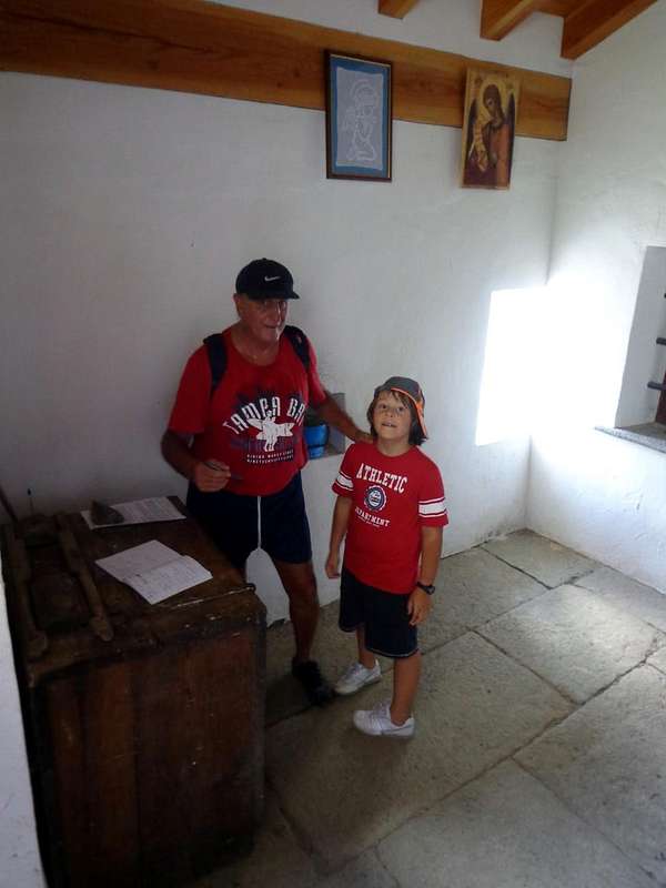
The descent on the Eastern Side begins just after the church with docile path, marked by a sign hanging on a fir. From this began a short diagonal, with two old trees cut down by the storm, which reaches a first bend to the left with a view to the remains of an ancient mountain pasture (or was this the original Hermitage?), with a further series of hairpin bends, steep, leading to the back of the great precipice falls with a jump of 346 meters below the Alp Charnicloz (1.038m) and more than 500 meters on Torrent Clavalité, downstream of the Alpage La Cerise (989m) and the entrance of Valley Fénis. The path is protected by a good wooden fence but, in the presence of children, you must multiply the Warnings. The environment is truly impressive: in front meanders across the walloon floor at the foot of Mount Charmontane (2863m), while the far end stands the perfect triangular pyramid of Tersiva, Emblem Fénis. A diagonal final underlying rock walls and vertical (Free Climbing routes are equipped), concludes by getting the path that splits into two sections this wall, protected on the left by small dry-stone walls, the Hermitage (around 1.750/60m) where, it seems, lived the Holy One. A white building, clinging to the rock and suspended over a void impressive, marks the end of the path. In addition you can not and you should not go. The Hermitage is made up of a beautiful little chapel with a door that can be opened by a latch at the top, a second iron gate marks the boundary between this input, a small table and sign the book for the transition from the Tourists and the local private Saint Julien. Icon on the wall, while on the right you can see the excavation in the rock, through which it was possible to carry out the construction (0h'15).
 |
VERSANTE OVEST o Normale di salita
The before Easterner & after Westerner Slopes of the Watershed Clavalité/Pieiller's Vallons towards the TORRASSE (1.854m), by SalVal
S'inizia con il sentiero n° 10B (cartello segnaletico in legno per St. Julien) al tornante-bivio tra i Villaggi di La Morgettaz e Le Pieiller (1.230 m); dopo un breve tratto in strada sterrata e subito apprwesso la fonte si arriva al Villaggio "Fantasma" di Le Coteau (1.234 m), in mezz'al bosco. Qui un altro similar cartello, appeso alla Baita, per metà in rovina e di fronte, indica verso Sud la direzione; una rampetta porta alla piccola cappella votiva Oratorio di San Giuseppe, subito alle spalle del vecchio villaggio, ormai quasi del tutto abbandonato (una sola casa ristrutturata) e dall'aspetto spettrale, ove in tempi neppure troppo lontani c'era la "Vita". Volgesi ad Est e con dolce salita si oltrepassa un ruscello con una pietra piatta, atta a mini ponte; lasciando al di sotto un'alpeggio, che sta per andar in rovina, con prato al limitar del bosco si continua progredendo verso Nordest sino ad incontrare delle placche di roccia levigata di color nerastro (adatte ad una mini arrampicata didattica; nella zona vi sono piante grasse). Il sentiero incomincia ad aumentar di pendenza indirizzandosi dapprima verso un colletto erboso, che scarta sulla sinistra, (Colletto di Saint Julien? Non attraversabile, perché al di là presenta un'erta parete rocciosa) e poi decisamente con direzione a Nord verso una lunga passerella in legno che una buona staccionata protegge da un notevole salto roccioso, soprastante il Vallone del Pieiller. Il tratto successivo porta, perlappunto, alla passerella in legno che "taglia" il Versante Ovest con un diagonale a Settentrione, molto esposto su d'un impressionante salto roccioso, ma protetto da staccionata in bilico nella parte finale perché, causa la neve invernale, é fuoruscita dalla sua base d'appoggio. Bisogna prestar un pò d'attenzione, soprattutto in presenza di bambini. Dopo la traversata della medesima, il sentiero sale verso Nord-nordest e con una bella gradinata in pietra, piacevole da percorrersi, raggiunge uno spalto con splendida vista sulla Valle Centrale, la Dora Baltea e la Città di Aosta; mentre ad Occidente si staglia la Catena delle Roèses (per fotografare bisogna venir di mattino), preceduta più a Mezzogiorno dalla Costiera che dal Monte Saint Julien risale alla vicina Torrasse (1.854 m), al Mont Corquet (2.527 m) per infine declinare con percorso semi circolare al Mont Roux (2.227 m), antica sede di Miniere di Ferro e Rame. Voltando a destra con un bel diagonale in mezzo al bosco, su sentiero morbido, poco ripido e sicuro costellato dallo spuntar di funghi, s'arriva al Santuario di Saint Grat con la sua Chiesa alta, bianca, ottagonale e squadrata (0h'35/0h'40). La vera Cima é appena sopra e la si può raggiunger in breve con una traccia su erba ed alberi subito a destra (Ovest) della stessa.
 |
DISCESA FACCIA ORIENTALE o Normale di Discesa all'Eremo
The NORTHTERN & WESTERN FACES over the Villages of Fénis Municipality, by SalVal
La discesa sul Versante Orientale incomincia subito appresso la Chiesa con docile percorso, segnalata da cartello appeso ad un abete. Da questi inizia un breve diagonale, presso due vecchie piante abbattute dalla tempesta, raggiungente un primo tornante verso sinistra con in vista i resti d'un antico alpeggio (oppure era questo l'originario Eremo?); con una successiva serie di tornanti, progressivamente più ripidi, si porta a ridosso del grande precipizio cascante con un salto di 346 metri sulla sottostante Alpe Charnicloz (1.038 m) e d'oltre 500 metri sul Torrent Clavalité, più a valle dell'Alpeggio La Cerise (989 m) ed all'imbocco della Valle di Fénis. Il percorso é protetto da una buona staccionata in legno ma, in presenza di bambini, si debbono moltiplicare le Attenzioni. L'Ambiente é veramente suggestivo: frontalmente si snoda tutto il fondovalle ai piedi del Mont Charmontane (2863 m), mentre là in fondo s'innalza la perfetta e triangolare piramide della Tersiva, Emblema di Fénis. Un diagonale terminale, sottostante a pareti rocciose e verticali (sono attrezzate Vie di Free Climbing), conclude portando il sentiero, che spezza in due tronconi questa parete con protezioni sulla sinistra tramite muretti a secco, all'Eremo (1.750/60 metri circa) ove, sembra, vivesse il Santo. Una costruzione bianca, abbarbicata alla roccia e sospesa su d'un vuoto veramente impressionante, ne segna la fine. Oltre non si può e non si deve andar. L'Eremo é formato da splenida Cappelletta con porta apribile per mezzo d'un chiavistello posto in alto; una seconda cancellata in ferro segna il limite tra quest'ingresso, con tavolino e il libro per firmare il passaggio da parte dei Turisti, ed il locale privato di Saint Julien. Appesa alla parete un'Icona, mentre sulla destra si può ammirare lo scavo nella roccia, tramite il quale é stato possibile realizzar la costruzione (0h'15).
 |
ALTERNATIVE ROUTE directly with Departure from Floor Valley
The SAINT JULIEN above the "Half Hillock" by Fénis Commune, by SalVal
The Old Road to the Saint Julien certainly would not start from Le Coteau, but directly by the Fund Valley with walking paths and trails now gone almost entirely into disuse, and the progressive construction of Roads Regional, Municipal and finally Intercrofting (sometimes reach up to 2.500 meters them) have in practice caused him to abandon these ancient means of communication and transport livestock within individual walloons or in connection different. HISTORICAL NOTE In fact, a whole network of transfer existed in High Altitude and, besides, you should know that the Alta Via delle Alpi was not running on motorways, but through the hills. For example, to go from Venice to Amsterdam and not vice versa certainly walked the Via Romana along the course of Baltea River, which leads from Ivrea Town to Aosta, the first is dated from the Orco Valley, we climbed over the Hills of Miserino, of Arietta, the Scaletta, the Bocchetta of Rancio or that of Acque Rosse (= Red Water), under the Tower of Lavina, to descend into the Valley of Cogne until Aymavilles, you crossed the Dora Baltea going up on the opposite side to the Village of Thouraz or Thora (buried by collapse of Becca France with its 600 inhabitants July 6, 1564), where he organized four famous European Exhibitions including important that the Seeds, you crossed the unnamed Hill 2.674 meters just to the east of Mount Fallère (3.061m) to go down to Etroubles and from there along the Great Saint Bernard Valley spanned the eponymous famous Pass to take to Switzerland and across half of Europe. In addition to these Great Highway where the most important thing was the Horse, but especially the Mule, (you only have to think that the Shelter Vittorio Emanuele II° at Great Paradise (4.061m) was supplied in such a way up to more than half of the seventies, then has arrived the Helicopter), there were large Muletracks were built by the Clergy in communion with the local Authorities for the famous Processions, the trails were also held in high regard and order in order to be able to reach the Alpine pastures, with the Herds. Paradoxically, of all that there is to be observed as they are kept in a better state the trails at the top, thanks to the mileage of hikers and climbers, while the bottom of the valley or Medium Hill went half destroyed, devoured by vegetation and brushwood. Without this small but necessary Preamble and returning Topic, said the chance to return to the Old along the entire route from Fénis to the Mount Saint Julien. In this case, the start may be made by the Village Le Perron (582m) going through the route n° 10 which gradually approaches the Torrent de Bioley reaching the road at an altitude of around 820 meters, here comes, but with a larger circle to the west, also the path n° 10A with the same starting point. In addition comes the route n° 11 from Tillier Hamlet (550m) and connecting to Réan Village (898m) in the Municipality of Saint Marcel. From this triple crossing of the trail goes up as n° 11A toward Southeast and reaches the farm at the Torrent de Bioley inserting the primitive n° 10 starting from Le Perron. With parallel path along the stream of the river basin arrive at Le Pieiller-de-Sermaz (1.075m) and the branching n° 10B reaches Le Coteau (1.234m) out halfway between the fountain and the village (1h'30s/2h'00, in total for the Saint Julien (2h'00/2h'30). This route allows, in addition to logically a harder workout, the discovery of many specific feature of the "Half Hillock" with a trip more rewarding. Factors not indifferent ...
 |
VIA ALTERNATIVA direttamente dal Fondovalle
La Vecchia Strada per il Saint Julien non partiva certamente da Le Coteau, bensì direttamente dal Fondovalle con sentieri e mulattiere ormai andati quasi completamente in disuso; la costruzione progressiva di Strade Regionali, Comunali ed infine Interpoderali (a volte raggiungono anche i 2.500 metri!) hanno in pratica fatto si che s'abbandonasero questi antichi mezzi di comunicazione e di trasporto pel bestiame all'interno dei singoli valloni o nel collegamento di diversi di loro. NOTA ISTORICA Infatti tutt'una rete di trasferimento esisteva in Alta Quota ed, inoltre, si deve saper che l'Alta Via delle Alpi non correva sulle Autostrade, ma attraverso i colli. Ad esempio, per recarsi da Venezia ad Amsterdam e viceversa non si percorreva certamente la Via Romana lungo il corso della Dora Baltea, che da Ivrea conduce ad Aosta; dalla prima si risaliva la Valle dell'Orco, si scavalcavano i Colli del Miserino, dell'Arietta, della Scaletta, la Bocchetta del Rancio o quello d'Acque Rosse, sotto la Torre di Lavina, per scendere in Val di Cogne fino ad Aymavilles; s'attraversava la Dora Baltea risalendo sul versante opposto al Villaggio di Thouraz o Thora (sepolto dal crollo della Becca France con i suoi 600 abitanti il 6 Luglio 1564), ove s'organizzavan 4 famose Fiere Europee tra le quali importantissima quella delle Sementi, si scavalcava il colle innominato 2.674 metri subito ad Est del Mont Fallère (3.061 m) per discendere in Etroubles; da qui percorrendo la Valle del Gran San Bernardo si valicava l'omonimo celebre Colle per scendere in Isvizzera ed attraversare mezz'Europa. Oltre a queste Grandi Autostrade ove il mezzo più importante era il Cavallo, ma soprattutto il Mulo, (é sufficiente pensare che il Vittorio Emanuele II° al Gran Paradiso (4.061 m) era rifornito in siffatta maniera fino ad oltre la metà degli Anni Settanta, poi é arrivato l'Elicottero), v'eran grandi mulattiere fatte costruire dal Clero in comunione con gli Enti Locali per le rinomate Processioni; inoltre i sentieri eran tenuti in gran considerazione ed ordine, onde potere raggiunger gli Alpeggi con le Mandrie. Paradossalmente di tutto ciò v'é da osservar come si sian mantenuti in miglior stato i sentieri in alto, grazie alla percorrenza di Escursionisti ed Alpinisti, mentre quelli di fondo valle o di Media Collina sian andati semi distrutti, divorati dalla vegetazione e dalle sterpaglie. Fatto questo piccolo ma necessario Preambolo e tornando in Argomento, dicevam della possibilità di tornare all'Antico percorrendo l'intero itinerario da Fénis al Monte Saint Julien. In si caso la partenza può avvenire dalla Frazione Le Perron (582 m) risalendo tramite il sentiero n° 10 che s'avvicina progressivamente al Torrent de Bioley raggiungendo la Carrozzabile in quota 820 metri circa; quivi giunge, ma con giro più largo ad Occidente, anche il sentiero n° 10A sempre col medesimo punto di partenza. Inoltre arriva il sentiero n° 11 dalla Frazione Tillier (550 m) e pur quello di collegamento da Réan (898 m) nel Comune di Saint Marcel. Da questo triplice incrocio il sentiero risale come n° 11A verso Sudest e raggiunge la poderale presso il Torrent de Bioley inserendosi sul primitivo n° 10 sempre di Le Perron. Con percorso parallelo lungo il rivo idrografico del torrente arriva a Le Pieiller-de-Sermaz (1.075 m) e con la ramificazione n° 10B raggiunge infine le baite diLe Coteau (1.234 m) uscendone a metà strada tra la fontana ed il villaggio (1h'30/2h'00; in totale per il Saint Julien 2h'00/2h'30). Questo percorso permette, oltre a logicamente ottenere un allenamento più duro, la scoperta di molte peculiarietà della "Mezza Collinetta" con gita maggiormente remunerativa. Fattori non indifferenti...


Per Turisti ed Escursionisti.
Mountain Condition
- You can get meteo information at the official site of the Regione Valle d'Aosta:
- Valle d'Aosta Meteo
Books and Maps
BOOKS:- "Guida delle Alpi Occidentali" di Giovanni Bobba e Luigi Vaccarone C.A.I. Sezione di Torino Volume II (parte II), 25 Maggio 1896.
- "Guida dei Monti d'Italia – Emilius Rosa dei Banchi-Parco del Mont Avic" di Giulio Berutto e Lino Fornelli - Club Alpino Italiano/Touring Club Italiano, Marzo 2005.
- "Diari Alpinistici" di Osvaldo Cardellina e Indice Generale accompagnato da Schedario Relazioni Ascensioni 1964-2019 (inediti).
 |
 |
 |
MAPS:
- Kompass "Gran Paradiso Valle d'Aosta Sentieri e Rifugi" Carta Turistica 1:50.000.
- L'Escursionista "Tour de la Vallée de Cogne Grand Paradis" Carta dei sentieri 1:25.000.
- Hapax "Les Sentiers" Comunità Montana Monte Emilius, Luglio 2000 1:25.000.
- Enrico Editore Ivrea-Aosta "Gruppo del Gran Paradiso" 1:50.000.
- L'Escursionista "Valle di Cogne" Carta dei Sentieri 1:25.000.
Important Information
- REGIONE AUTONOMA VALLE D'AOSTA the official site.
- FONDAZIONE MONTAGNA SICURA Villa Cameron, località Villard de la Palud n° 1 Courmayeur (AO) Tel: 39 0165 897602 - Fax: 39 0165 897647.
- A.I.NE.VA. (Associazione Interregionale Neve e Valanghe).
Useful numbers
- Protezione Civile Valdostana località Aeroporto n° 7/A Saint Christophe (Ao) Tel. 0165-238222.
- Bollettino Meteo (weather info) Tel. 0165-44113.
- Unità Operativa di Soccorso Sanitario Tel. 118.