
-
 10255 Hits
-
 72.07% Score
-
 2 Votes
|
|
Route |
|---|---|
|
|
50.05472°N / 126.10091°W |
|
|
Mountaineering |
|
|
Most of a day |
|
|
Class 4 |
|
|
5.1 (YDS) |
|
|
1 |
|
|
 Victoria Peak S Face Route Victoria Peak S Face Route |
Route Description
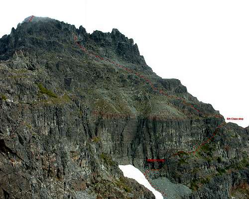
Refer to the Victoria Peak parent page for approach directions to the tarn camp under the south ridge.From the tarn camp described in the approach section, walk north up the south ridge following cairns and flagging. Do not go too far along the ridge crest itself. If you arrive at “The Notch” directly below the steep upper S ridge, you’ve gone too far. The “Notch” is impassable anyway. Optimally, aim to travel 30-40m below the crest to the right (east). This enables the easiest access to 2 snowfields that are crossed to enter the south cirque with minimal down climbing. Snow conditions are often hard and/or icy, so crampons and axe are often essential here. Descend the second snowfield into the south cirque with its imposing sheer cliffs. The cliff band must be passed to gain the upper south face and the summit. From the base of the second snowfield climb up talus and locate a wet gully that traverses off to the right (east). This gully is hidden until you’ve climbed up and are adjacent to the entrance. Go up the gully and emerge on a series of heather ledges which traverse right across the base of the south face cliffs and which end at the east ridge. At the end of the ledges locate a 10-12 m high corner, which is climbed at 5.3-5.4 to gain the upper south face.
 Descending the First Snowfield |  The Hidden Gully |  The 5th Class Step. |  South Face Traverse |
Descend by reversing the climbing route. Most people rap the 5.4 corner and anchors are in place. Providing route finding is not an issue, for the average party, the summit is approx 9 hours return from the tarn camp.