
-
 2366 Hits
-
 80.49% Score
-
 12 Votes
|
|
Mountain/Rock |
|---|---|
|
|
38.01360°N / 107.7284°W |
|
|
Ouray |
|
|
Hiking, Mountaineering |
|
|
Spring, Summer, Fall |
|
|
12580 ft / 3834 m |
|
|
Overview
 Angel Knob
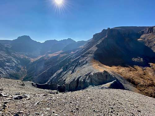 Angel Knob descent
"Angel Knob" is an unofficial name for 12er in the Sneffels Range of San Juan Mountains. It is rarely summited peak and seeked only by true peakbaggers. The easiest route up is very loose class 3 - not an enjoyable scramble. I chose to explore this peak via Oak Creek Trail as my only objective. Most peak baggers summit this peak in a combination with Corbett Peak and Ridge, Angel Knob, Whitehouse Mountain, Mount Ridgway and Reconnoiter Peak. This whole loop has actually less mileage if accessed from north - backcountry Burn's Hut, more elevation gain. If doing only Angel Knob from the historic town of Ouray, your mileage will be slightly longer and elevation gain will still be enough to give you a nice work out.
Colorado Rank: 948
Parent Lineage: Whitehouse Mountain
Class: 3 (very loose)
Uncompahgre National Forest
Getting There
Town of Ouray is a beautiful historical town located in northern San Juan Mountains. It is located along the highway 550 and it is about 6 to 6.5 hr drive from Denver. The Million Dollar Highway continues south from Ouray towards Durango - it winds its way through the mountains and is one of the most scenic drives in Colorado (and the most dangerous road in North America).
Route
 Oak Creek Trail
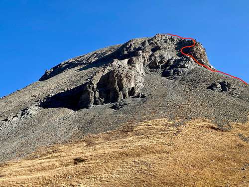 Angel Knob
Oak Creek Trail: The trailhead starts at Oak Street in Ouray. Oak Street parallels Main Street on the west side of the Uncompahgre River. 3rd or 7th Avenue have bridges providing access to Oak Street. There is limited parking on Oak Street and park here if you have 2WD car. 4WD vehicles can take Queen Street one block and turn left on South Pinecrest Drive and drive up steep 4WD road to the trailhead. Again, there is a limited parking only for a few vehicles.
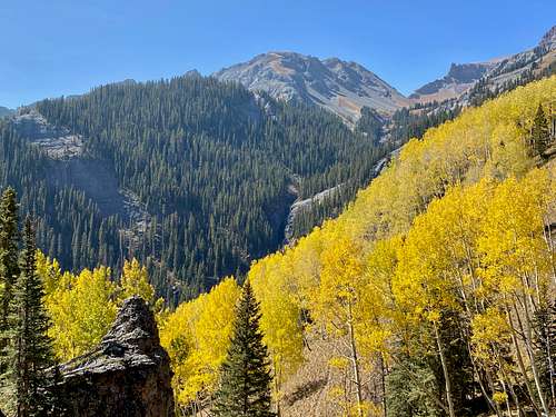
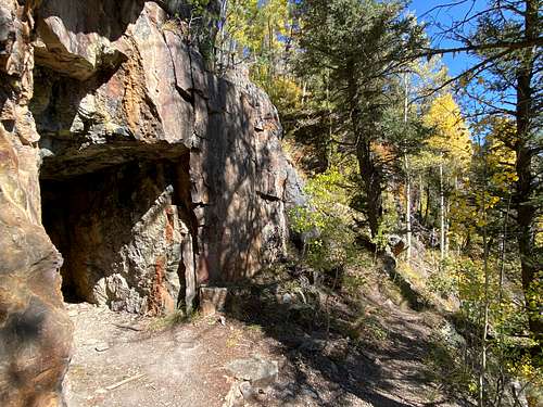
The trail is well marked. Initially, the trail is the same as Ouray Perimeter Trail and Twin Peak Trail. At 1.0 mile, take the left fork up into Oak Creek Gorge (well marked). The picturesque canyon is reached in 0.5 mile, soon the falls are glimpsed. Follow the trail past two mine portals. From the mines you enter some dense forest, then an open meadow, and you will start to get first glimpses of Angel Knob. Ascend to the highest point over a low saddle on the trail and when the trail starts to drop, leave the trail and head west. Going is slow here due to fallen timber and zigzagging between fallen trees. Occasionally, you can follow some animal trails. I followed a ridge upwads, but eventually I reached cliffs, which were loose. I descended about 600 feet and was able to to find a path here and there traversing towards a more open area between Whitehouse Mountain and below Angel Knob. Oak Creek stays on the west side of your path. Some sections of the traverse are harder and exposed, search for the easiest route. Once you get to the meadows, the going is easy and the views of Corbett Ridge, Whitehouse Mountain and Angel Knob are spectacular. Follow easy path on grass below Angel Knob, ascend to a small saddle and enter a loose gully. The gully starts easy, and around a small corner it steepens and continues to be very loose. There is a short section of very loose class 3 scrabmle and shortly above it, it is an easy stroll to the summit. I built a small cairn there and left a summit register. The views are amazing.
Return: I chose to explore the west side of the Oak Creek, but would not recommend return this way. I went through much fallen timber and was lucky to find an easy path to cross the gorge. Oak Creek has sections of steep gorge.
List of John has a few trip reports describing the combination of peaks accessed from Burn's Hut. Basically, you follow the route up Corbett Peak, go over the ridge, descend down towards Angel Knob, ascend up White House and continue towards Mount Ridgway and finally Reconnoiter Peak. Mileage is slightly shorter when all those peaks combined from the north, but elevation gain is over 7,000 feet.
Red Tape
There is no red tape. Hiking, parking are free.
When to Climb
Summer and early fall are the easiest. Early summer may offer a snow climb and less loose rock danger. Winter poses a high avalanche danger.
Camping
Camping - there is primitive camping if approached from the north along the forest road. You can also book a stay at San Juan Mountain Huts. For more information click here.
If coming from the town of Ouray, you have a multitude of hotels in the town of Ouray. Developed campground nearby would Amphitheater Campground.
External Links