
-
 15701 Hits
-
 89.01% Score
-
 28 Votes
|
|
Mountain/Rock |
|---|---|
|
|
45.49750°N / 7.04440°E |
|
|
Mountaineering, Skiing |
|
|
Spring, Summer |
|
|
10948 ft / 3337 m |
|
|
Overview
Becca della Traversiere 3337 m
Becca della Traversiere 3337 m is the Southernmost summit on the ridge separating the Valgrisenche from the Val di Rhêmes. It is a pyramid-shaped mountain belonging to the Alpi Graie, group Grande Sassière and Rutor Alps (also known as the Central Alpi Graie) a subsection of the Alpi Graie of which they form the central part. A mountain covered by glaciers such as the Gliairetta Glacier to the North-West and the Goletta Glacier to the North-East, which are only marginally touched by the two Normal routes climbing this peak. Becca della Traversiere is not visible from the valley floor, neither from Valgrisenche nor from the Val di Rhemes. Despite its hidden position, this summit offers an unusual view on Goletta and Gliairetta glacier basins, besides an impressive view to Granta Parei, Tsanteleynaz North face, Gran Sassiere and all the highest summits in Val di Rhêmes.

Two different ascent routes are possible: from Val di Rhêmes and from Valgrisenche. Both routes converge on the Bassac Deré col and continue along the easy North-West Ridge. To "take-it-easy" perhaps the best thing is to stay overnight at the Refuge Benevolo (Val di Rhêmes) or at the Refuge Bezzi (Valgrisenche). I suggest the one-day ascent only for well-trained persons, in fact these two routes are very long. The crossing of two valleys is an interesting solution, or, better a four days trek.

|

|
Getting There
Rhêmes Notre Dame route. Common start: Introd village. Bus station to Rhêmes Notre Dame. - From Turin/Milan. Motorway A5, exit Aosta Ovest. Follow Courmayeur direction, until reached Villeneuve. Here follow to Val di Rhêmes direction. - From Switzerland, Martigny (Grand St. Bernard Tunnel/Pass). Drive to Aosta, then follow Courmayeur direction on SS.26. Once reached Villeneuve, turn to Val di Rhêmes. - From France (Mont Blanc Tunnel or Petit St. Bernard Pass). Do not enter in motorway A5, drive through SS.26 Aosta direction. Before arriving in Villeneuve, turn right to Val di Rhêmes direction. - From Introd. Once passed the tiny village, after 2 km. turn right to Val di Rhêmes (or Rhêmes Notre Dame). Follow paved road until is possible. The road ends in Thumel, 1.879 m. No parking problem.
Valgrisenche route. Common start: Arvier village. Bus Station to Valgrisenche/Bonne. - From Turin/Milan. Motorway A5, exit Aosta Ovest. Follow Courmayeur direction, until reached Arvier. Follow to Valgrisenche direction. - From Switzerland, Martigny (Grand St. Bernard Tunnel/Pass). Drive to Aosta, then follow Courmayeur direction on SS.26. Once reached Arvier, turn to Valgrisenche. - From France (Mont Blanc Tunnel or Petit St. Bernard Pass). Do not enter in motorway A5, drive through SS.26 Aosta direction. Pay attention: the crossroad to Arvier, Valgrisenche is just outside a tunnel! From Arvier. Drive to Valgrisenche. Once arrived in the village of Valgrisenche, move on to Bonne direction. Stay on rightside of Beauregard dike (dam). The paved road ends in Ussellieres. Park the car and follow to Rifugio Bezzi direction.

Routes
- Val di Rhêmes route
A fairly easy route. At the beginning of the season, with snow in the gully before the Bassac Déré pass and on the following ridge, the ascent requires an ice axe and crampons (F). At the end of the season in the absence of snow it is an easy route without particular difficulties (EE). A rather long route, it is advisable to stay overnight at the Rifugio Benevolo.
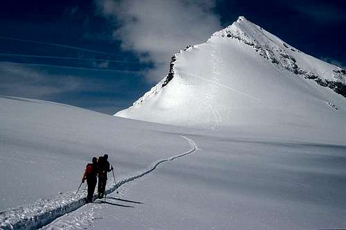
- From Thumel parking lot follow for a few hundred meters the paved road, up to a junction: it is advisable to take the path n. 13 to the left to the Benevolo Refuge. In Barmaverin (boulder on the right) you can follow the path n.14 on the right, which leads to the Bivacco della Forestale and then to Lago Goletta. In this case we do not pass through the Benevolo Refuge. If instead you want to reach the refuge you continue on the main path 13 until you resume the road near a bridge and a waterfall. Cross the bridge and then with a series of shortcuts reach the Refuge . A third possibility is to follow a path marked but less frequented (13D) before the bridge just under the shelter,that allows to slightly shorten the path, leading further the Rifugio Benevolo, but the path is steeper and more tiring. This will save about 10 minutes. - From Benevolo hut follow the signpost to Col Bassac Derè and Lago di Goletta (2706 m), Bassac Dèrè, cross the two wooden bridges and continue to climb to reach a ruined mountain hut 2313 m, where you meet a crossroads (here comes the path 13D).The path with a long series of hairpins reachs a saddle between the Granta Parei on the left and theTruc Blanc on the right.A flat stretch leads in a few minutes to Lago Goletta.You skirt the lake on the right, climbing an easy moraine up to a small plateau that precedes the last ramp before the col Bassac Derè 3082 m, which you reach shortly (snowy slope in early season). Orientation table.

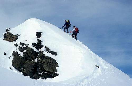
From the col, where there is also the path coming from the Valgrisenche (Bezzi Refuge), turn left along the obvious trail cutting the southern slope of Becca della Traversiere fore-summit and reaches a collar between the fore-summit and the summit.Climb the steep slope of stones and debris to the visible cross. In early season crampons and ice-axe needed.
Descent by the same route
- Valgrisenche route
The ascent takes place on debris or snowy slopes - at the beginning of the season - and a small glacier avoidable by a trail under the western slope of Punta Bassac Sud. Another route without particular difficulties, anyhow in the beginning of the season the ascent route requires the use of ice axe and crampons
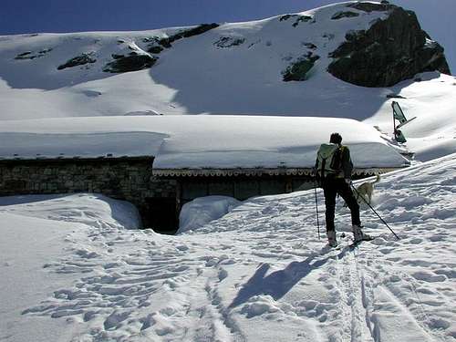
From Usellières cross the bridge and continue along the dirt road. At the first fork continue on the right (signs for the Bezzi Refuge), getting the Alpeggio Le Challet 1926 m, then you pass a stream on a wooden bridge. Near some ruined mountain huts at 2036 m the dirt road ends. Continue along an excellent marked trail at first almost flat, then rising on steep grassy slope with a series of hairpin bends, passing a narrow area and reaching a grassy ridge, then a wide plateau, the mountain huts of the Vaudet Alps and the Rifugio Bezzi 2284 m (1.40 / 2.00 hours from Usellières).
From the hut, follow the plateau southwards, initially keeping to the center and then gradually turning to the left. At the end of the plateau follow the marked trail, pass a series of grassy slopes, to which follows a debris gully overcoming a band of broken rocks and leading to a grassy shelf. Cross the moraines of the Bassac Derè Glacier to the edge of the Gliairetta Glacier. Continue to the left in the direction of the slope that goes to Colle Bassac Derè up to the edge of the Gliairetta glacier, then continue to the left crossing the ridge and west face of Punta Bassac South slightly uphill, towards the slope that leads to the Colle Bassac Derè 3082 m. From here continue as described in the previous route.

|

|
Ski-mountaineering

See here on SP the dedicated page by Antonio Giani
Becca della Traversiere by Ski-Mountaineering from East
Red Tape
The right hydrographic side of Val di Rhêmes is situated inside Parco Nazionale Gran Paradiso. The boundary of the park is exactly the Dora river. The right side is within the park, the left one is outside. In PNGP are forbidden camping, dogs or other animals ... lot of restrictions. No parking fees or other tickets required.
When To Climb
Mountaineering - From late June to late September. Warning: huts closure is about the third week-end in september. Make a call for doubts. Ski-mountaineering - from March to May
 |
 |
Huts

Owner: C.A.I. Torino
Size: 61 places (5 places winter room)
Hut Phone: +39 0165 936143 Mobile: +39 3454238692 Mathieu +39 3497817040 Micol
Approach: from Aosta follow the road SS 26 toward Courmayeur until Villeuneve, go past the village and take the road toward Introd. Proceed on the road to Rhêmes Notre Dame. Once you reach it go until the end of the road in Thumel. This is where you park the car. From here it start the hike, about 1h45, path 13

Situation: Alpe Vaudet di Valgrisenche
Size: 80 places (10 places winter room)
Hut Phone: +39 0165 97129 Mobile: +39 3482641927
Info: rifugio@rifugiobezzi.com
Approach: from Aosta continue in the direction of Courmayeur up to the village of Arvier; at the roundabout take the second exit continue to Valgrisenche (15 Km). After the capital, continue towards Bonne, cross the village and skirt the lake to the end, descending to the village of Surier / Uselière. Park the car. The refuge can be reached after about 2 hours along an easy path.
- Rifugio Chalet de l'Epee
Size: 60 places (8 places winter room). Private.
Phone: +39016597215
This hut is not directly involved in the routes to the sumit of Becca della Traversiere. Only for a 4 days trek round Grande Traversiere and Grande Rousse.
Camping
Forbidden within the park, if not for emergency.
Meteo
Guidebooks and maps
Map: Valsavarenche, Val di Rhêmes e Valgrisenche - Parco Nazionale del Gran Paradiso, IGC, sheet 102, scale 1:25.000