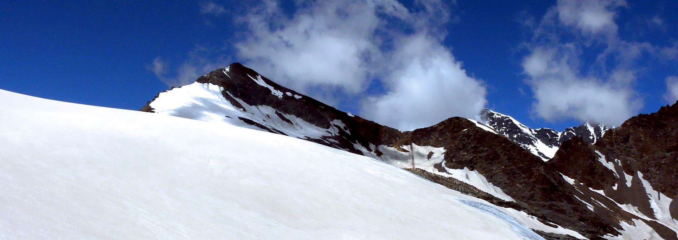
This mountain is located between the squared pyramid of Granta Parei (3.387m) and the indented Punta di Bassac Deré (3.352m) and immediately above the wide and greatly expanded Glacier of Goletta, while bordered to the West by the Valgrisenche and in the South with the French Valley of the Isère. This climb can be regarded as a really and true classic route for the Ski-Mountaineering from the Valley of Rhêmes departing from the Refuge Gian Federico Federico Benevolo, almost at the end of the same valley. Beautiful views on the two Valleys of Valgrisenche Rhêmes and towards the nearby Granta Parei, Tsanteleina, Grande Sassière and Grande Traversière.
Questa montagna é collocata tra la squadrata piramide della Granta Parei (3.387 m) e la fratagliata Punta di Bassac Deré (3.352 m) ed al di sopra dell'esteso Ghiacciaio di Goletta, mentre confina ad Occidente con la Valgrisenche ed a Mezzogiorno con la francese Valle dell’Isère. Questa salita può essere considerata come un vero e proprio classico percorso per lo Sci-Alpinismo dalla Valle di Rhêmes con partenza dal Rifugio Gian Federico Benevolo, quasi alla fine della medesima vallata. Belle viste sulle Valli di Grisanche e Rhêmes nonché in direzione della Granta Parei, Tsanteleina, Grande Sassière e Grande Traversière.
First Ascents
S Arête: R.C. Nichols, and J.V. Favret mountain guides, (Jul 30th, 1865).
S Arête from Goletta Pass: J.V. Favret mountain guides, (Jul 30th, 1865).
SS-W Arête from Goletta Pass: V. Gayda and C. Thérisod, (Aug 03th, 1906).
W Side: J.P. Farrar and J.V. Favret, (Jul 28th, 1902).
In winter: Unknown.
Getting There
BY CAR:
From France: through the Mont Blanc Tunnel or the Col du Petit Saint Bernard: you can drive on SS.26, following directions for Aosta and, before arriving in Villeneuve, turn right towards Introd. Alternatively, you can take Motorway A5 (at Courmayeur or Morgex) and exit at Aosta Ovest.
From all the other directions: get to the Aosta Ovest exit of Motorway A5. Then drive on SS.26 Aosta, in the direction of Courmayeur; just after Villeneuve turn left towards Introd.
BY PLANE:
Aeroporto "Corrado Gex" Saint Christophe (Aosta).
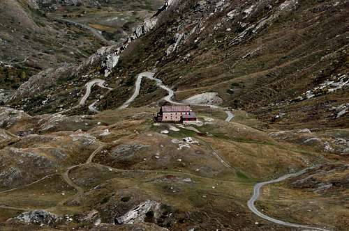
Enter the valley and, at the fork between Valsavarenche and Val di Rhêmes turn to the right (Rhêmes). Cross all the villages to arrive to Rhêmes Notre Dame and follow to Thumel (car parking), herefrom, following the dirt road on the right side (ascending) of the valley, or, better with snow, a track on the left that passing throught some fine woods leads you to the Rifugio Benevolo (2.285m).
Route Description
From the Rhêmes ValleyA)- (East Crest or Northeast Slope or Ski-Mountaineering Route) From Gian Federico Benevolo Refuge (2.285m) go down (Southwest direction) at small bridge 2.269 meters over Rhêmes Dora Torrent; by a diagonal path n° 13d/HRG (High Glacial Route) go to the fork 2.420 meters, (little cairn. Turn right (Northwest) climbing the grassy promontory (2.615m). Change again direction (South-southwest) and reach the last ramification of Granta Parei long North-northeast Spur. Continue below the crest to the right (West), by obvious trace and white limestones debris to quota 3.078 meters at the beginning of North-northeast Ridge. Turn 90 degrees towards the West and cross the Higher Goletta Glacier staying high, below the Northern Face. Turn West-southwest and, by a progressive diagonal ascent, reach the start of the two parallel routes by the Eastern Crest or Northeast Slope (immediately more in right), both without great difficulties. (3h'20/3h'40).
B)- (North Ridge Standard or Normal Route) With previous route just almost until the end of the Comba de Golette; then the next and namesake lake (2.706m) to the West-southwest to proceed on the bottom of the valley until you reach the Colle Bassac Deré (3.082m). Finally, after overcoming a minor altitude, towards the top with easy Crest North (3h'15/3h'45).
DESCENT: With same Route.
Dalla Val di Rhêmes A) - (Cresta Est o Versante Nordest o Via Sci-Alpinistica) Dal Rifugio Gian Federico Benevolo (2.285 m) scendere a Sudovest al sottostante ponticello (2.269 m) sulla Dora di Rhêmes; risalire a Norsovest con il sentiero n° 13d/HRG (Alta Via Glaciale), insino al bivio 2.420 m, (ometto). Da questo punto girare a destra (Nordovest) e risalire l'erboso promontorio (2.615 m). Cambiare ancora direzione, salendo le estreme propaggini del lungo Contrafforte Nord-nordest della Granta Parei. Procedere sottocresta ad Ovest sempre della Granta Parei su evidenti tracce risalendo detriti e blocchi di bianco calcare sino a quota 3.078 metri, all'inizio della Cresta Nord-nordest; girare pressoché ad angolo retto ad Occidente ed attraversare in quota l'Alto Ghiacciaio di Goletta al di sotto della Parete Nord. Tramite progressiva salita in diagonale ai margini del ghiacciaio medesimo, dirigersi ad Ovest-sudovest portandosi verso glì attacchi delle parallele vie della Cresta Est o sull'attiguo e nevoso Versante Nordest (appena più a destra). Indifferentemente tramite una delle due e senza eccessive difficoltà in Vetta (3h'20/3h'40).
B) - (Cresta Nord o Via Normale) Con la precedente via insino quasi al termine della Comba di Golette; quindi dal successivo ed omonimo lago (2.706 m) procedere verso Ovest-sudovest sul fondo del vallone fino a raggiungere il Colle Bassac Deré (3.082 m). Infine concludere, dopo aver superato una quota secondaria, alla Cima con la facile Cresta Settentrionale (3h'15/3h'45).
DISCESA: Con la stessa Via.
Difficulty
These routes can be considered BSA/F+.
Gli itinerari sono da classificare in BSA/F+.
Essential Gear
For High Hiking gear; in winter with ski, ice-axe and crampons.
Da Alto Escursionismo; in inverno con sci, piccozza e ramponi.
Parents refers to a larger category under which an object falls. For example, theAconcagua mountain page has the 'Aconcagua Group' and the 'Seven Summits' asparents and is a parent itself to many routes, photos, and Trip Reports.

 3009 Hits
 79.04% Score
 10 Votes