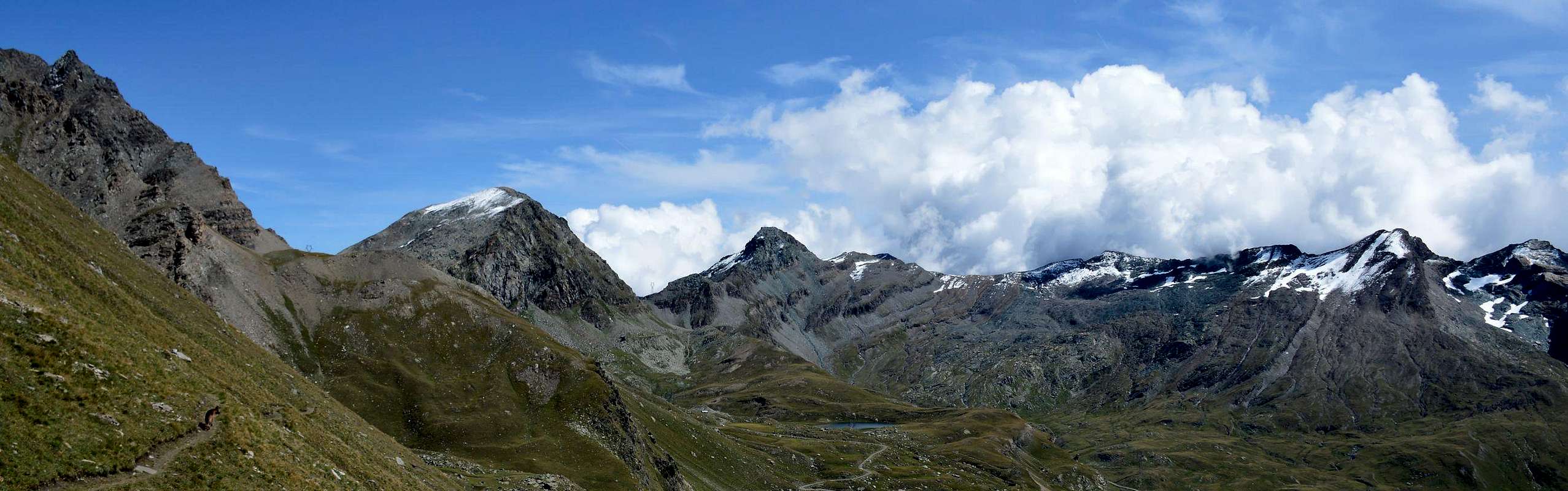
This turns out to be a "classical crossing" to be counted among the busiest in the Aosta Valley as it combines with a beautiful hiking trail Grand'Eyvia (Great Water) into the Valleys of Cogne (to the West) and the Ayasse Torrent along the entire Champorcher (to the East). Can be carried out starting from one or the other valley, which present the shelter Dondena and Miserin in Champorcher Valley and the "Sogno di Berdzé or Sheperd Dream" near the end of the long Vallon of Urtier above the Lillaz Hamlet. A crossing that also it allows you to visit the famous Sanctuary Miserin at the homonymous lake and at the foot of Mont Rasciàs and both valleys to be made with beautiful scenic trails often parallel or concomitant with the farm roads. The alpine environment is wild and unspoiled on both fronts and also has a number of lakes and small appreciable sources. While in Cogne dominate the Punta Tersiva with Grivola and Gran Paradiso in the background, in Champorcher are the pyramids of Moussaillon, Mont Delà and Mont Glacier to dominate the North side, while in the South and towards Piedmont stands out like a saber la Rosa dei Banchi. Let to everyone the choice of the direction of the route, although we recommend that from West to East, perhaps without going to Dondena but simply stopping at the clear waters of Miserin.
Questa risulta essere una traversata "classica" da annoverare tra le più frequentate in Valle di Aosta in quanto unisce con uno splendido itinerario escursionistico le Valli della Grand'Eyvia o Cogne (ad Ovest) e dello Ayasse o Champorcher (ad Est). Può essere effettuata partendo da una o l'altra vallata, che presentano i Rifugi di Dondena e del Miserin in Valle di Champorcher e del "Sogno di Berdzé" quasi al termine del lungo Vallone dell'Urtier al di sopra della Frazione di Lillaz Una traversata che permette inoltre di visitare il famoso Santuario del Miserin presso l'omonimo lago ed ai piedi del Mont Rasciàs e per entrambe le valli da effettuare con splendidi sentieri panoramici spesso concomitanti alle strade poderali. L'ambiente alpestre risulta selvaggio ed ancora incontaminato su di entrambi i fronti dove si trovano inoltre numerosi laghi e piccole apprezzabili sorgenti. Mentre a Cogne dominano la Punta Tersiva con Grivola e Gran Paradiso sullo sfondo, a Champorcher sono le piramidi di Moussaillon, Mont Delà e Mont Glacier a dominare il versante Settentrionale, mentre a Meridione e verso il Piemonte si staglia come una sciabola la Rosa dei Banchi. Lasciamo ad ognuno la scelta della direzione dell'itinerario, anche se consigliamo quella da Ovest verso Est, magari senza scendere a Dondena ma fermandosi presso le limpide acque del Miserin.
APPROACHES & ROUTES from Lillaz (Cogne) or Dondena (Champorcher)
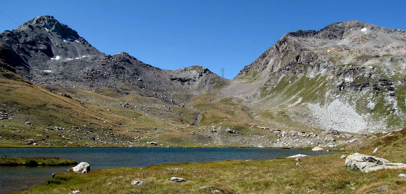
A) - From Lillaz towards Urtier Vallon and by Sogno di Berdzé Refuge: Starting from Cogne (1.534m) you must arrive (bus or car) to the car parking of Lillaz (1.617m). Follow the path n° 13/TVC/Alta Via n° 2 below upaved road, until reach Baite di Gollies Low and Upper (1.831m, 1.869m; here you can also get along the same route with slightly longer, less direct but certainly more scenic). Move on until tiny Church of Crêt (2.020m; wooden fountain), clearly visible from lowlands. Once gone beyond Tsavanis (2.296m; fountain), preceded by a magnificent waterfall upon the Torrent Urtier and above the private farms dirt road and Manda (2.370m) Pastures, the refuge is reached, immediately after a fresh spring water from a rock in a great boulder (3h'30/3h'45, from Lillaz parking). From "Sogno di Berdzè (2.526m), to continue on the path n° 13/TVC/Alta Via n° 2 for the Fenetre de Champorcher (2.826m) until the alternative (2.682m); through the path n° 10F, with diagonal route to left, to (1h'00 from refuge).
A) - Da Lillaz attraverso il Vallone dell'Urtier appoggiandosi al Rifugio Sogno di Berdzé: Dall'abitato di Cogne (1.534 m) in bus o in auto raggiungere la ridente frazione di Lillaz (1.617 m), dove si parcheggia l'auto nel grande piazzale sito quasi al centro del villaggio. Percorrere il sentiero n° 13/TVC/Alta Via n° 2 al disotto della strada poderale e lungo la sponda Settentrionale del Torrente Urtier fino alle Baite di Gollies Dessous e Dessus (1.831 m, 1.869 m; qui si può arrivare anche percorrendo la medesima con itinerario leggermente più lungo, meno diretto, ma sicuramente maggiormente panoramico); continuare fino alla Chiesetta del Crêt (2.020 m; bella fontana scavata nel legno), ben visibile dal basso, e oltrepassati gli Alpeggi di Tsavanis (2.296 m; fontana), preceduto da una bella cascata sopra il Torrent Urtier al di sopra della poderale, ed il successivo di Manda (2.370 m) si raggiunge il Rifugio "Sogno di Berdzè" (Sogno di Pastore) presso l'Alpe di Peradzà, subito dopo un tornante seguito da un lungo rettilineo in leggera ascesa giusto appresso una fresca sorgente sgorgante da un gran masso nella roccia (3h'30/3h'45 dal parcheggio di Lillaz). Dal "Sogno di Berdzè" continuare sul sentiero n° 13/TVC/Alta Via n° 2 per la Finestra di Champorcher (2.826 m) sino al bivio (2.682 m); tramite il sentiero n° 10F, in diagonale verso sinistra, salire in direzione della Finestra passando presso un rivo con sorgente (1h'00 dal rifugio).
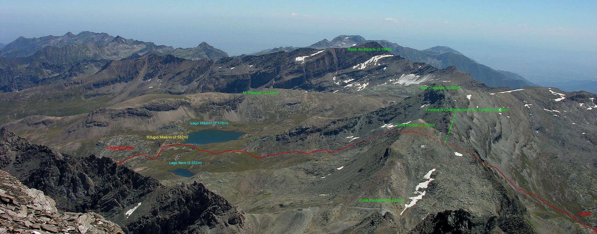
B) - From Champorcher also from Dondena Refuge to Miserin Shelter neighbor the Lake: Champorcher-Château (1.427m) go to the Village La Cort where, shortly afterwards, began the dirt "Royal Route" numbered 9/High Way n° 2; crossed to the Alps Vardette, Brenvei, Champlong Grand, Grand Pianas and Leituerie you arrive at the small parking lot just above the Village of Dondena (2.110m, panels and reports signs in yellow). After a short descent we cross the Torrent Ayasse on a small stonebridge continuing through the private farms dirt road (prohibition of passage for cars) that reaches the Dondena Refuge (2.200m). From this continue Westward with it, concomitant with the path n° 7B/Alta Via n° 2, concluding with a short ascent to the South; or starting immediately behind the same, better, with the path n° 7 to reach the Miserin Shelter (2.582m; Sanctuary; 1h'00/1h'15) at the lake of the same name. This trip is already satisfactory for itself along a route that each year is crossed by a famous procession which takes place August 5th, dedicated to Madonna delle Nevi (Our Lady of the Snows) and full of a centuries-old tradition and with the participation of the inhabitants of the nearby valleys of Piedmont. It should surely the second path, the more "rapid" and less "busy" from the crowd of Walkers. Miserin continue Westward towards a grassy-rocky promontory just to the right by "Truc del Lago" (2.703m). Absolutely not climb directly the same but, using a path, to double in North beyond a grassy rounded promontory and with trail progressively towards Northwes reaching the Window or Finestra of Champorcher (EE/F; 1h'15/1h'30 from Dondena to Lake Miserin; 1h'45/2h'00 until the Finestra di Champorcher).
B) - Da Champorcher o dal Rifugio di Dondena appoggiandosi al Rifugio del Lago Miserin: Da Champorcher-Château (1.427 m) salire fino alla Frazione La Cort dove, poco oltre, inizia la "Strada Reale" in terra battuta numerata 9/Alta Via n° 2; superate le Alpi di Vardette, Brenvei, Grand Champlong, Grand Pianas e Leituerie si arriva al piccolo parcheggio appena sopra il Villaggio di Dondena (2.110 m; pannelli e segnalazioni segnaletiche in giallo). Dopo una corta discesa si guada il Torrent Ayasse su di un piccolo ponte proseguendo tramite la strada poderale (divieto di passaggio per le auto) che raggiunge il Rifugio Dondena (2.200 m). Da questo continuare verso Ovest con la medesima, concomitante con il sentiero 7B/Alta Via n° 2, per concludere con una piccola salita a Mezzogiorno; oppure partendo subito dietro lo stesso, e meglio, con il sentiero n° 7 raggiungendo il Rifugio del Miserin (2.582 m; Santuario; 1h'00/1h'15) presso l'omonimo Lago. Questa risulta già gita soddisfacente per se stessa lungo un itinerario che ogni anno viene percorso da una famosa Processione effettuata il 5 di Agosto e dedicata alla Madonna della Neve; la stessa é ricca d'una tradizione centenaria ed alla quale partecipano pur gli abitanti delle vicine Valli del Piemonte. Conviene di certo il secondo sentiero, più "rapido" e meno "affollato" dalla massa. Dal Rifugio Miserin indirizzarsi verso Ovest verso un promontorio roccioso-erboso subito a destra del "Truc del Lago" (2.703 m); non salire assolutamente in modo diretto ma, sfruttando un sentiero, doppiare lo stesso a Settentrione oltre un erboso tondeggiante dosso d'erba indirizzandosi più a Nordovest e raggiungendo il Colle o Finestra di Champorcher (EE/F; 1h'15/1h'30 dal Rifugio al Lago Miserin; 1h'45/2h'00 dal Miserin alla Finestra).
Parents refers to a larger category under which an object falls. For example, theAconcagua mountain page has the 'Aconcagua Group' and the 'Seven Summits' asparents and is a parent itself to many routes, photos, and Trip Reports.

 3883 Hits
 80.49% Score
 12 Votes