
-
 4368 Hits
-
 0% Score
-
 0 Votes
|
|
Route |
|---|---|
|
|
39.88268°N / 105.43158°W |
|
|
Trad Climbing |
|
|
Spring, Summer, Fall, Winter |
|
|
Half a day |
|
|
5.7 (YDS) |
|
|
3 |
|
|
Overview
There are three large, prominent buttresses on the west face of Thorodin. CMC Route ascends an obvious 400 foot line up the Second Buttress (the central of the three) in 3 pitches, topping out on a sub-summit of Thorodin Mountain. While the climbing is so-so, the views, position, scenery, and solitude of the route make this a very inviting line and alternative way of summiting Thorodin via a technical route. Protection is generally good throughout; this would make a great first climb of a more committing route for a beginning trad leader. The route gets great sun in the afternoon and provides views that get better and better as you ascend.
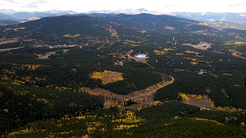
Views from the route
Getting There
The Second Buttress of Thorodin Mountain is located beneath the sub-peak that is to the southwest of the actual highpoint of Thorodin. When viewing the west face of Thorodin Mountain, it is the large, central rock formation. Approaches to this crag may start at Panorama Point or, better yet, a small parking lot on the south side of Gap Road about .4 miles east of Panorama Point. Note that the nearest rock buttress to the north of the road is the backside of the First Buttress, with the Second Buttress directly behind, and north of it.
From this vicinity, hike north cross country through the forest, and up the shallow drainage area that forms to the south of the main summit of Thorodin. Aim for the notch in between the First and Second Buttresses. Cross through the notch, onto the west face of the mountain, and walk north along the base of the Second Buttress to right angling slabs directly beneath the deep cleft that forms CMC Route. The second pitch is the obvious, wide crack/shallow chimney feature that ascends straight up the middle of the formation.
The start of the climb is located to the left of the main crack system the route follows, but directly beneath the roof/chimney of the second pitch. A short, dead tree marks the base and start of the route.
The approach takes about 45 minutes as it's only about 1 mile, but allow at least an hour if it's your first time. The approach is entirely cross country, so it may be wise to carry a map and/or GPS.
Route Description
Pitch 1
Begin on slabs and climb right angling cracks, then trend left, past a tree and up a runout slab. Continue up until you are able to move right into the main crack system and belay at a large ledge with a tree with slings. 5.6, 190 feet.
Pitch 2
Climb up the main crack system, starting off the ledge with a strenuous but short wide crack, 5.6. Climb easy ground for a ways to the base of the chimney/roof crux. Stem the gap, and tackle the roof via good holds and good gear, and immediately find yourself at a comfortable belay ledge. The anchor takes small cams and nuts. 5.7, 150 feet.
Pitch 3
Easy ground leads to an awkward tunnel on the right, followed by easy climbing to the top. 5.4, 50 feet.
Descent
Scramble off to the north to the notch between the Second Buttress and the Third Buttress. The summit of Thorodin Mountain is a 10 minute hike to the northeast, or hike down to the west, and then through brush and a boulderfield back to the base of the Second Buttress.
Essential Gear
One set of cams from Blue Metolius size up to BD #3 Camalot and a set of nuts is plenty for this route. Be sure to bring at least 6 or 7 extendable draws as the first pitch wanders a little. 60 meter rope. You could potentially link this into 2 pitches with minimal gear placements and a 70 meter rope.
External Links
- Mountain Project Entry, with great approach beta photos.