
-
 2832 Hits
-
 79.04% Score
-
 10 Votes
|
|
Route |
|---|---|
|
|
46.58805°N / 11.83249°E |
|
|
Download GPX » View Route on Map |
|
|
Hiking, Skiing |
|
|
Spring, Summer, Fall, Winter |
|
|
A long day |
|
|
Hike or Skii Tour |
|
|
Overview
 Val Chedul seen from Crespeinajoch / Forca Crespeina Val Chedul seen from Crespeinajoch / Forca Crespeina |
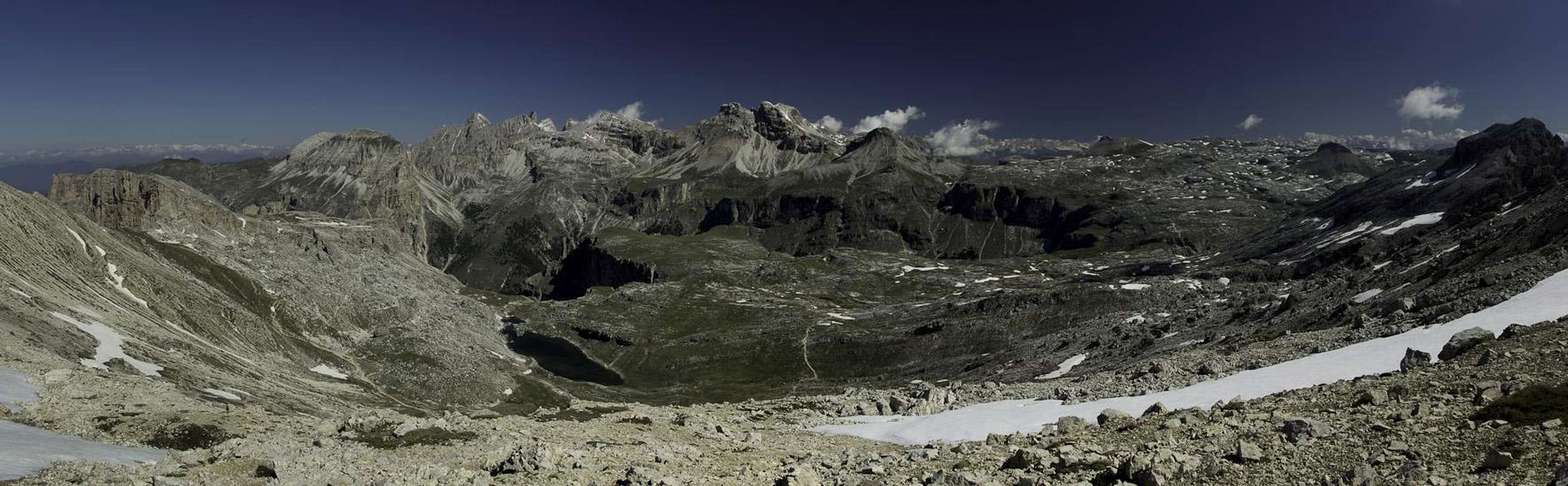
This route does not serve any mountain in particular even though you can climb Sass Ciampac as an extension of it. Moreover, Col de la Sone, Zwischenkofel and Puezkofel are viable options which, however, add significantly to the overall hiking time of a long route. Even if you pass by all of these summit the circle around the Crespeina and Gherdenacia Plateaus is one of the most beautiful outings you can do in the western Dolomites. I hiked it three times so far and I'm convinced that the first time got me addicted to hiking and climbing mountains back in 1996.
The tour is far from difficult. It is a simple hike up a steep valley, Val Chedul, towards Crespeina Pass, a traverse across Crespeina Plateau towards Forca de Ciampac and another plateau traverse across Gherdenacia Plateau towards Rifugio Puez where the steep and long descent back down into Langental / Vallunga starts. You can extend exploring the plateau on all sides from Rifugio Puez with impressive sights all around.
  |
The only exposed section is in Forca Ciampac, a pass where two very steep valleys run up to meet. There is a bit of protection and I have seen many a hiker hesitate to pass through it. The remainder of the route is pure enjoyment. Take your time enjoying the views and - if you happen to visit in late spring or early summer - to enjoy the flora.
Getting There
 Corvarra seen from the saddle between Sas da Ciampej and Sas da Ciampac
Trailhead for the Puez Plateau round trip is Wolkenstein / Selva di Val Gardena. In summer you can best start at the parking lot of the Dantercipies Ski Lift. In winter you can do the same but will have to pay a fee. To reach Wolkenstein / Selva di Val Gardena follow the following itinerary:
- Take the Brenner Motorway A22 to the exit of Waidbruck / Ponte Gardena.
- Turn onto S242 east to Wolkenstein / Selva di Val Gardena.
- After you passed the Ciampinoi Cable Car turn left onto Strada Dantercepies
Route Description
 |
- General:
- Start altitude: 1630m
- Summit altitude: 2672m
- Prevailing exposure: S
- Type: Hike
- Protection: None
- Start altitude: 1630m
- Effort: 2 - Elevation gain: 1100+m
- Power: 3 – Long and strenuous
- Psyche: 1 – Easy – some exposure in Forca Ciampac
- Difficulty: 1 - Easy
- Orientation: 1 – Well marked trails all around, exploring the plateaus on your own can become tricky
From the Dantercepies parking lot you first have to hike into Langental / Vallunga passing by the ruins of Wolkenstein Castle on the lower slopes of Monte Stevia. You pass a first mountain on your southern side after which Val Chedule opens above you. The hiking trail steeply climbs into the mouth of the valley where a dense forest awaits you. And endless seeming trail heads up into the valley turning from south-east to east. Above the timberline you realize tha you hike beneath the “backsides” of the Pizes dla Cir, the fronts of which are well known, towering above Grödner Joch / Passo Gardena.
 |  |  |
After passing the towers a busy hiking trail joins from the pass and together they head for Forca Crespeina, a beautiful saddle with one of the famous carved crosses made in Grödnertal / Val Gardena. The saddle offers good views back through Val Chedul but mainly is a good spot to scout the further route across the Crespeina and Gherdenacia Plateaus. Here you have to decide whether you tackle Crespeina Plateau directly or whether you want to hike the detour to Sas da Ciampac which rejoins the direct route in the eastern part of the plateau.
 |  |  |
The plateau route is straightforward – well marked – and running close by the beautiful Crespeina Lake. The Sas da Ciampac Route isn’t exactly difficult but it traverses steep slopes which can carry snow late into spring. It is strenuous and exposed in its topmost section. However, the views deep into the Sella Group reward you for the exertions. The descent follows the ridgeline of the mountain, descending into the saddle that separates it from Sas da Ciampei. From there a route across the karst plateau leads back to the plateau route.
 |  |  |
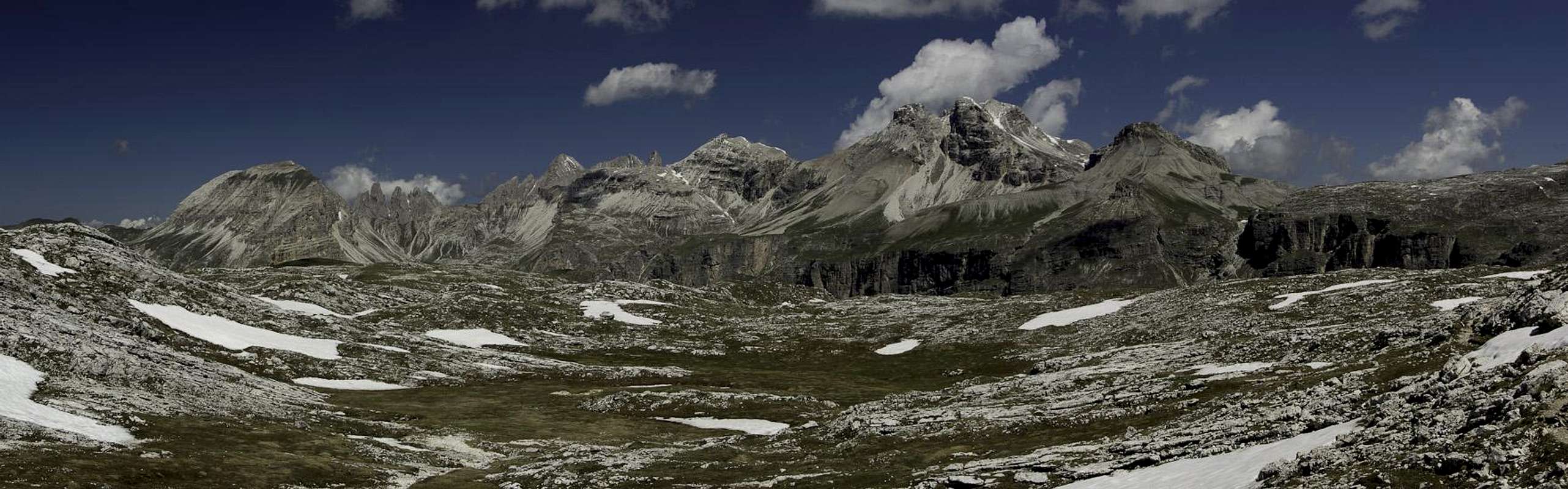
The route now heads directly for Forca da Ciampac. The cut of this pass is so sharp that you notice it real late – just as you get close to it. The path runs down onto the eastern side of the saddle, where it meets the route from Edelweißtal / Val Stella Alpina. Together they climb back up into the cut, where the incredibly steep Langental / Vallunga Route joins. Scramble out to the eastern side where you set foot on the Gherdenecia Plain.
 |  |  |
The regular trail now heads around the end of Langental / Vallunga to reach Puezhütte / Rifugio Puez. In doing so it offers some of the most wonderful views into the glacier carved valley. Gherdenacia itself is a karst plateau which you will only realize if you explore its northern or eastern parts from the hut. Which is something I would really recommend. In particular, heading out north towards Forcella Puez across the short distance of some 700m – 800m gives you a good impression of karst areas in general. You have to negotiate several dolines and finally find yourself right above the north face where the plateau drops off for some 500m into the valley below. It is a very brittle face with no good climbing routes. However, erosion carved impressive formations out of the rock.
 |  |  |
Back at Puezhütte / Rifugio Puez turn west along the edge of Langental / Vallunga until you reach Rio di Puez. Here the long descent into Langental / Vallunga starts. It runs through the valley north face and is rather steep in general. It offers wonderful views into and across the glacier carved valley with its vertical faces. In particular, Col Turont on the southern side attracts attention mainly because of it situation. With a bit of imagination you can see it as a giant medieval castle with huge vertical buttresses.
You reach the valley floor rather in its central part and have to hike out for another 5 km until you reach the Dantercepies parking lot.
Essential Gear
 Col Turont above a summer meadow
Regular hiking gear suffices for most of the year. I have seen climbers tackle the steep route from the end of Langental / Vallunga towards Forca da Ciampac with crampons in June.