
-
 9123 Hits
-
 80.49% Score
-
 12 Votes
|
|
Route |
|---|---|
|
|
Hiking, Scrambling |
|
|
Spring, Summer, Fall, Winter |
|
|
Half a day |
|
|
Overview
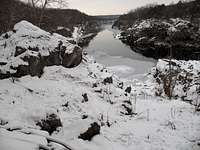
Mather Gorge
This is probably the nicest hiking outing on the Virginia side of Great Falls. It features a rocky gorge with several short but dramatic cascades, nice views of Mather Gorge from high vantage points, and pleasant woodland scenery. It is an all-season outing, and each season has something to recommend it: the wildflowers and higher water levels of spring, the escape from the summer heat that the forest canopy offers, the colors and mushrooms of fall, and the ice and and the sterile beauty of the naked trees in winter.
The "scrambling" is optional and comes in when one wants to leave the trail. Although part of this route accesses the majority of the Virginia-side crags at Great Falls, those technical crags are beyond the scope of this page. For information about those crags, please access pages for them from this page's parent page.
Update: A section of the trail between Georgetown Pike and the Difficult Run/Ridge Trail intersection is washed out. Experienced hikers will be able to negotiate the washout without difficulty, but it would be dangerous for inexperienced hikers and most children.
Getting There
Georgetown Pike: Off Route 193 (Georgetown Pike) in Great Falls between Old Dominion Drive and Towlston Road, there is a large parking area on the south side of the road. Be extremely cautious when pulling in and out of here, as the road is narrow and winding and visibility is poor.Great Falls Park: From the western part of I-495, a piece of the Capital Beltway, take Exit 44 for Route 193, Georgetown Pike; this is the second exit south of the Maryland border. Drive west for a few miles until you see the well-signed road leading to Great Falls Park. Turn right and follow the road about a mile to the entrance station. Enter and take an immediate right to reach a large parking area used by most climbers and boaters here; this is commonly called the "Lower Lot" since it is downhill from the entrance station. Don't expect to find a parking spot here after 10 on a nice weekend day. From here, hike toward the river and turn right on the River Trail.
Route Description
From one trailhead to the other, the route is about 3 miles. There is not much elevation gain overall, but there are some hills and some rock sections that would earn the route a "moderate" rating in the typical guidebook. However, experienced hikers in decent shape will likely find it easy. This is an outing I like to enjoy on weekend mornings when I need to get away from my progeny for a few hours.Due to the two trailheads, there are a few options for this route. Of course, one can retrace his or her route going back. Another option is using the Matildaville Trail or Old Carriage Road (see the trail map) on the return; both are quiet woodland hikes, and the former serves up a little area history through ruins and interpretive signs. The option I like best, however, is leaving a bike at one trailhead, driving to the other, and then riding back (both the Old Carriage Road and the Ridge Trail are open to riders, and they are easily ridden on hybrid bikes. If you choose this last option, you are probably better locking up your bike at the Great Falls Park trailhead since it is heavily used and your bike is thus less likely to be a target of thieves and vandals.
Considering that, I'll describe the route from Georgetown Pike to Great Falls.
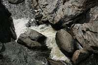
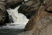
Start hiking south on the Difficult Run Trail (from the left end of the parking lot as viewed from the road). The trail can be muddy near the beginning and gets rocky in places later but is never truly difficult. Note that the trail is very popular with mountain bikers, so be alert. Soon, the trail passes beneath Georgetown Pike, and in short order, the stream goes from lazily meandering to rushing as it enters a rocky gorge. Difficult Run is never far from the trail, and it is both safe and easy to get close to most of the cascades. Boulders abound, and one fairly sizable cliff (for this area) offers some Class 4 scrambling to a vantage point directly above what is arguably the most spectacular section of the gorge (you can also hike to that vantage point from the trail).
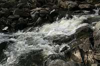 In the gorge...
 | 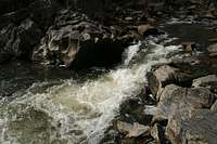
| 
|

| 
| 
|
About a mile along, there is an intersection where a sign points the way uphill to the Ridge Trail. Continue on a short distance, though, to reach the trail's end and view the confluence of Difficult Run and the Potomac River. In this last section, the trail has been eroded away and actually unnerves many novice hikers and many parents, but any mountaineer will welcome the brief taste of rugged terrain.
From trail's end, do one of three things:
1. Hike back to the spur to the Ridge Trail.
2. Climb the cliff just west of the trail (Class 4/low Class 5) and then hike over to the Ridge Trail.
3. Head upstream along the Potomac's bank a short distance and then scramble up some Class 3 cliffs to find and follow a use trail leading to the Ridge Trail. I've gone this way with a five-year-old, so it's not a big deal.
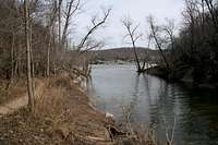 Confluence
 | 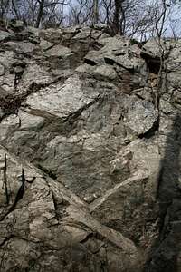 Cliff by trail's end
 | 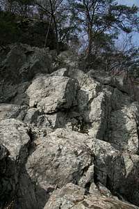 Upstream cliff
 |
Follow the Ridge Trail a little more than half a mile to a signed intersection with the River Trail and bear right onto that trail.
The River Trail is the most scenic one on the Virginia side of Great Falls because it stays high and skirts the tops of several climbing crags, where there are unbroken views 50-70' down sheer cliffs into Mather Gorge. As mentioned earlier, please see this page's parent page for information about those crags.
 Mather Gorge...
 | 
| 
| 
|
Eventually, the River Trail ends at a broad, open area swarmed with picnic tables and, frequently, people. Follow a trail left to reach the "Lower Lot" at Great Falls. However, you can continue straight ahead to reach the three overlooks of Great Falls. Go knowing that your time among other outdoors enthusiasts is over, though, for you will be sharing the spectacular views with just about every type of person imaginable.
It's interesting to note the difference between the Lower Lot and the "regular" parking area here. Climbers, kayakers, cyclists, and avid hikers-- in other words, those who intentionally break a sweat in the outdoors-- tend to park in the Lower Lot, whereas the people you go to the wilderness to get away from tend to use the other lots.
Warning: Do not drink the water here. It is an urban area, and as clear and refreshing as Difficult Run may look, its watershed drains numerous subdivisions and commercial areas.