
|
|
Mountain/Rock |
|---|---|
|
|
36.01380°N / 51.42180°E |
|
|
12201 ft / 3719 m |
|
|
Overview
Click for a link to the Iranian Ski Federation Website. Check out the 6 minute long jazzy video clip about Dizin. It is quite interesting.
Not too many people in Tehran have heard of Mt. Seechal, but everyone knows where the Dizin Ski Resort is.
Mt. Seechal has the distinction of serving as Iran’s largest ski resort. On a straight line, this mountain is only 20 km (12.5 miles) away from the northern-most neighborhoods of Tehran, but depending on the route you take, it will be a 70 km (44 mile) or a 120 km (75 mile) drive.
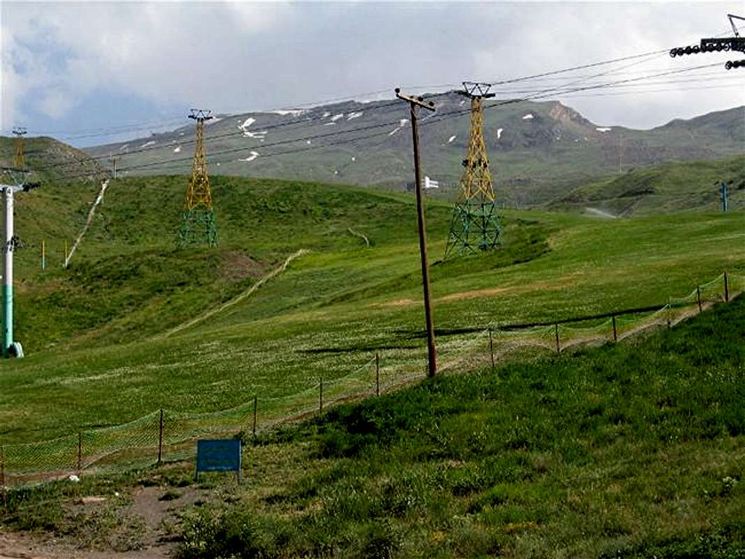
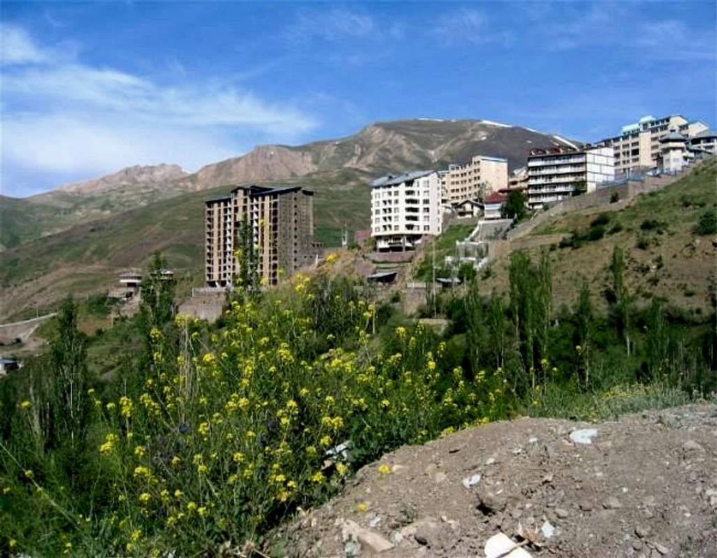
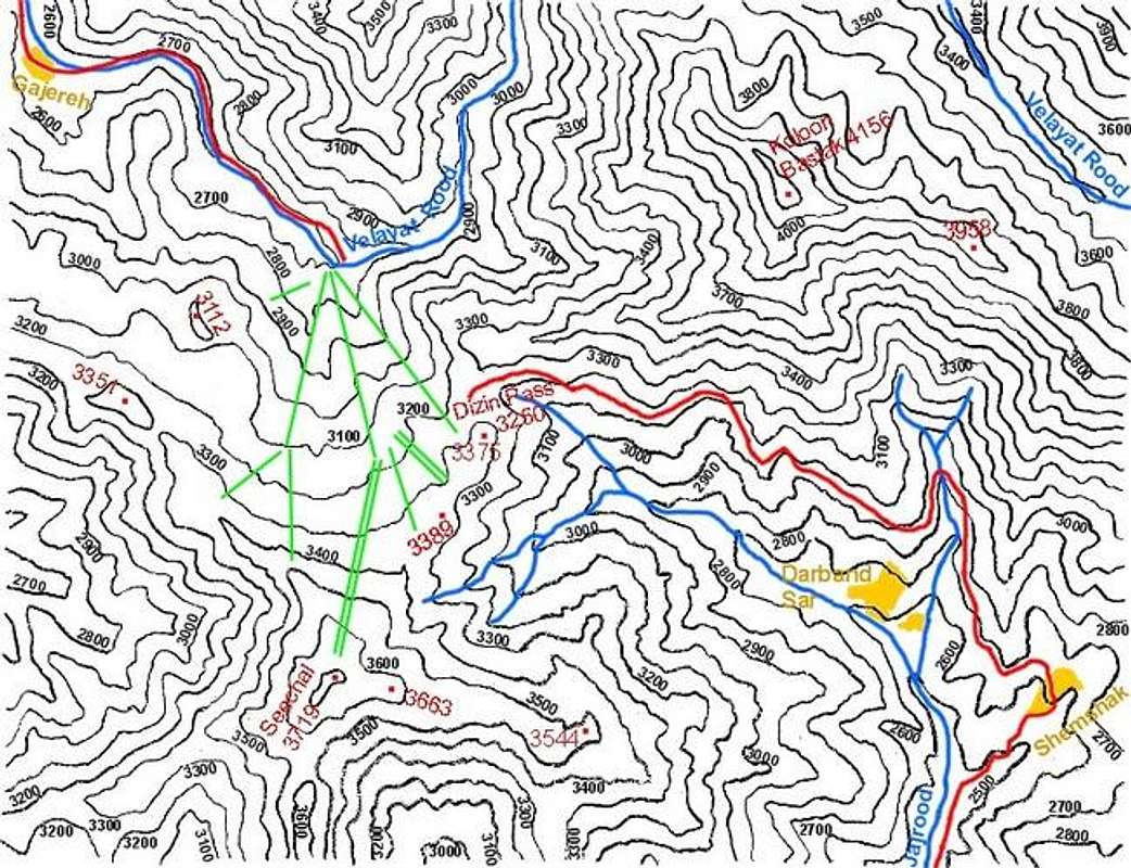
The northern slopes of Mt. Seechal are very gentle and drop 1000 m (3280 ft) into the bottom of the “Velayat Rood” River Valley (This river is the origin of the Karaj River). The ski facilities are on the northern slopes. These include 3 gondola lines, 2 chair lifts and 6 T-bar lifts. The main line takes you from near the bottom of the Velayat Rood River Valley (2700 m, 8850 ft) to a spot in the middle of the mountain (3175 m, 10400 ft) where you will have access to many other lifts including the one that takes you to the top of the resort at about 3650 m (12000 ft) just below the summit of Mt. Seechal (when I was there in late June of 2004, another lift that went to the very top was being built). From the top to the bottom, you will have a 4 km (2.5 mile) long run with a 950 m (3100 ft) drop. The usual ski season is from December until late April. In early summer, a beautiful mixture of green grass and flowers along with patches of snow covers the upper slopes. From mid-summer to early autumn, the snow disappears and the grass turns yellow. Summertime grass skiing has become popular and in recent years several international competitions have been held at Dizin.
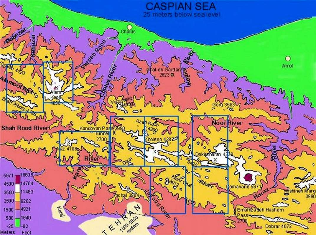
The eastern, western and southern slopes of Mt. Seechal are much steeper. A 3250 m (10650 ft) ft saddle known as “Dizin Pass” separates Mt. Seechal from the 4156 m (13635 ft) Mt. Koloon Bastak to the northeast. Koloon Bastak is a part of what is known as The Middle Wall of Central Alborz. This refers to a very long ridgeline, with many side branches, that starts with the 5671 m (18606 ft) summit of Mt. Damavand to the east and runs 80 km (50 miles) west to near the Kandovan Pass on Karaj-Chalus Road. Except for the 3420 m (11220 ft) “Kabood Pass”, the elevation of these connecting ridgelines never drops below 3500 m (11483 ft). About 45 peaks higher than 4000 m (13123 ft) have been identified along the length of these ridgelines. After Mt. Damavand, the highest of these peaks is the 4387 m (14393 ft) Mt. Kholeno.
From the upper slopes of the Dizin Ski Resort, the most magnificent view is obviously that of the giant volcanic cone of Mt. Damavand in the eastern horizon. The proximity of Mt. Seechal to the Middle Wall of Central Alborz will provide you with good views of some of its nearby peaks including:
Those around the 4387 m (14393 ft) Mt. Kholeno
Those around the 4234 m (13891 ft) Kaman Kooh Peak
The peaks of Sarak Chal (highest point 4210 m, 13812 ft)
Mt. Koloon Bastak (4156 m, 13635 ft)
Other good views will be those of the 4850 m (15912 ft) Alam Kooh and the Takhte Soleyman Massif 60 km (36 miles) to the northwest as well as the peaks of the Naz/Kahar sub-range (highest point 4108 m, 13478 ft). If you hike the short distance from the top of the ski lift to the summit of Mt. Seechal, you can look south to get a great view of the northern slopes of Mt. Tochal (3964 m, 13005 ft). The city of Tehran sits at the base of the southern slopes of Mt. Tochal (Click for a link to the Mt. Tochal page).
In summer, climbing Mt. Seechal will be nothing more than a pleasant hike up the gentle slopes. Access can be gained either from the Karaj-Chalus Road, which takes you to the base of the mountain at 2700m (8850 ft) or via the Jajrood River Valley (Shemshak Rd) which takes you up through the Dizin Pass to reach the top of one of the ski lifts at 3250 m (10650 ft). The second option is a much shorter drive and will take you much closer to the summit.
Mt. Seechal is a beautiful peak that can act as a quick getaway from the hustle and bustle of busy Tehran. It was here in 1978, when I was 13 years old, that I learned to ski and appreciate the majesty of the mountains. Revisiting this area after 21 years of separation was quite an emotional occasion. In my heart, there will always be a very special place for Dizin.
 |  |  |  |  |
Getting There
To reach Dizin, you have two options:
1) From northeast Tehran, take the Babai Expressway to Lashgarak Road exit. This road takes you up the hills above northeast Tehran to an elevation of 1950 m, where it makes a series of switchbacks and drops down to the bottom of the Jajrood River Valley (1700 m).m It then follows the river upstream to the town of Shemshak (2600 m) where another ski resort by the same name can be found. The road then goes up the slopes of Mt. Koloon Bastak steeply and in 12 km, it goes through the Dizin Pass to reach the top of one of Dizin’s ski lifts (3250 m). Distance from Tehran is 70 km.
2) From Tehran, follow the Tehran-Karaj Expressway 40 km west to the town of Karaj (elevation 1400 m) then turn north on the Karaj-Chalus Road. This road follows the Karaj River upstream to the Kandovan Tunnel. Just before the start of the switchbacks to the tunnel (2250 m), a 13 km long side road takes you up the Velayat Rood River Valley to the bottom of Dizin Ski Resort (2700 m).Distance from Tehran is 120 km.
 |  |  |  |  |
Red Tape
No red tape. (You obviosly have to pay to get on the lifts). |  |  |  |  |
When To Climb

Easiest in summer.
Camping
Stay in Tehran or use the above link to get info on local hotels. |
Mountain Conditions
In summer, the weather is generally clear.CLICK FOR THE FORECAST FOR THE SUMMIT OF DIZIN SKI RESORT.