
-
 15537 Hits
-
 87.31% Score
-
 24 Votes
|
|
Route |
|---|---|
|
|
68.98721°N / 15.10528°E |
|
|
Hiking |
|
|
Summer |
|
|
Most of a day |
|
|
Mainly a walk, some fixed ropes |
|
|
Overview
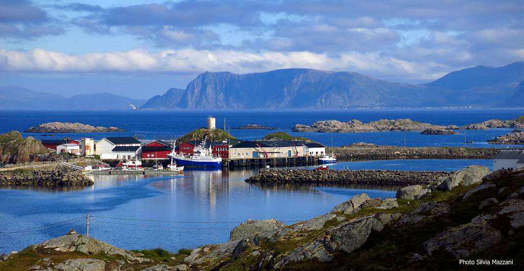
Dronningruta (The Queen's Route)

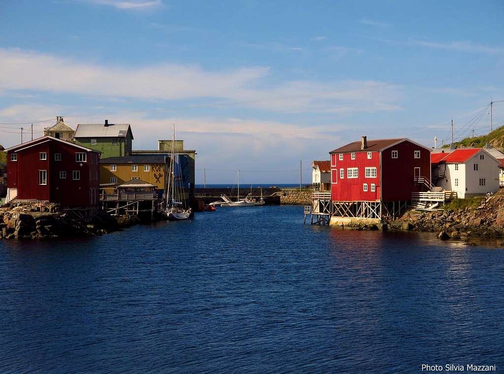
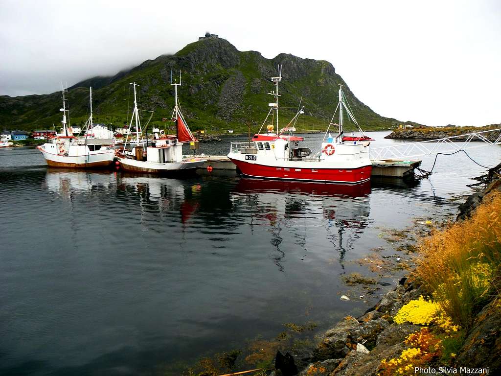
A veritable pearl is lying in the Northern Langøya, Norway‘s third largest island, belonging to the Vesterålen archipelago. Can’t just be missed by the trekkers in reason of its exciting mountain views, in addition to a breathtaking seascape. It’s Dronningruta – which means "The Queen's Route" - a round trail 15 km. long, running up the peaks and along the shore line, through an unbelievable landscape. The route connects the two picturesque villages of Stø and Nyksund, in the Øksnes municipality, located on the shoreline at the northern end of the island. Stø is a lively, colorful and picturesque fishing village, while Nyksund, an old village once abandoned after being destroyed by a violent storm in the Fifties, was recently rebuilt and revitalized as the "cultural capital" in Øksnes, through the efforts of some inhabitants artists. Both the villages are really unforgettable! This spectacular trek was so named in honour of Queen Sonja of Norway, who performed the crossing during her trip in Vesterålen in the year 1994.Linking two of the most picturesque fishing villages in Vesterålen archipelago, the Queen's Route runs through a superb landscape getting to the Northernmost tip of Langøya, looking out across the Atlantic Ocean. The route comes from an ancient path and in the past years it was used by different people, including midwife on Stø, who used to pass through it to attend the births in Nyksund.
Now it's a well-worn DNT trail, passing through a very varied landscape and running along the ocean's edge. Actually consists of two different routes: a 10 km (6 miles) high route with a total elevation gain of 900 m and a 5 km low route, which mostly follows the coast. Together, they form a varied and incredibly beautiful round walk.
If you wish to complete the trail with the achievement of an easy summit, remember you have two additional opportunities along this route: the summit of Sorkulen m. 517 and the summit of Kjolen m. 456. You can climb one or both these two easy summits along the trail by two brief diversions from the main route.
Getting There
Getting to Vesterålen
There are various possibilities. The nearest airport is Stokmarknes Airport, Skagen, in the municipality of Hadsel. It is located on the island of Langøya, about 5 kilometres from Stokmarknes and about 20 kilometres southwest of Sortland, the door to Vesterålen, but it's a small airport and it schedules few flights. The nearest major airport is Evenes, located on the mainland between Harstad and Narvik, with frequent flights to and from Oslo. The mainland is connected with Vesterålen by some spectacular bridges, which allow to get to Sortland rather quickly. Bodö airport may be an alternative, if you wish to visit also the Lofoten archipelago. In fact, the Vesterålen archipelago can be reached easily also from the nearby Lofoten by a connection via ferry boat from Fiskebøl on Austvågøy island (Lofoten) to Melbu on Hadseløya (Vesterålen). Of course the legendary Hurtigrut stops in Vesterålen, where the ship had the birth. You can bring your car on some of the Hurtigrutten boats. Whatever the chosen route to Vesterålen, you must get to Sortland.
You can get to Nyksund or Stø by local bus from Sortland, or by private car. By car, you need to take RV 820 from Sortland in the direction of Myre. At Frøskeland, turn right onto RV 821. When you reach the centre of Myre, you turn onto FV 935 in the direction of Stø or Nyksund. It’s possible to start the trail both from Stø and Nyksund, as the trail is a round trip between these two fishing villages. Depending on which direction you have chosen to go hiking, in Myre you will have to decide to reach Stø or alternatively Nyksund, because the roads diverge here.
Dronningruta (The Queen's Route) report
Dronningruta (The Queen's Route) report
Maximum altitude: m. 440 (Fingghameia)
Difficulty: essentially a walk with some stretches on rough terrain; a slightly exposed traverse is equipped with fixed ropes
Difference in level: 440 m
Starting point: Stø
Time required: 6-8 hours round trip, included the diversion to Nyksund
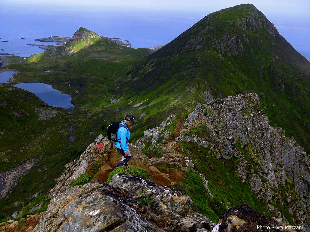
A veritable pearl, providing stunning views over Vesterålen archipelago. Can't be missed! The ground is sometimes rough, but there are not difficult passages and the only stretch slightly exposed is equipped with fixed ropes. Anyhow a good physical shape is required, because the round trip is quite long.

As told in the previous chapter, the trail is a round trip between Stø and Nyksund, and you decide on your own where you want to start. However, most of the hikers found no problems on either of the directions. Information panels concerning the crossing are located in both the two possible starting points. Here it's described the entire round trip starting from Stø, including the optional diversion to the village of Nyksund. This complete trip can be done in 6-8 hours. From anywhere you begin your trek, you come across a stretch of steep uphill; starting from Stø, you will find immediately the stretch with the most elevation gain and it’s for that reason that I personally recommend to do the crossing in the way described below.


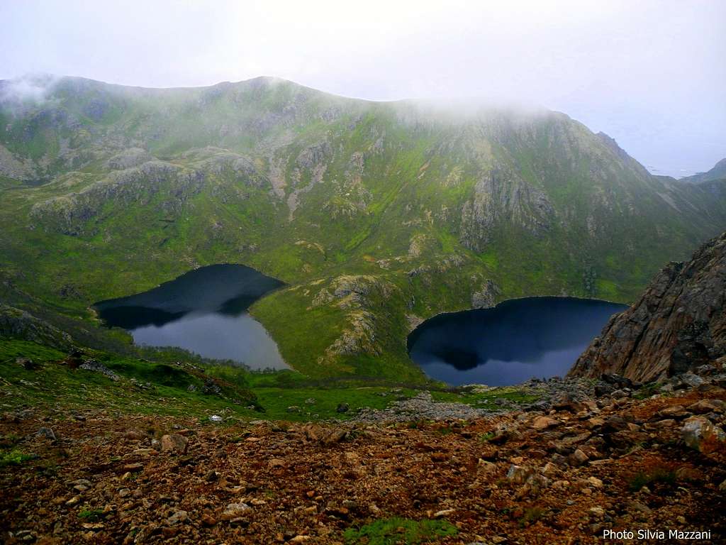
In Stø there are two path signposted “Dronningruta”, both starting on the left hand of the road crossing the village in the direction of the campsite Stø Bobilcamp, located at the edge of the village. The path closer to the campsite leads to the coastal trail and I suggest to leave this one for your return. The second path starts a few hundred meters before getting the campsite and therefore it’s closer to the center of the village. Take this one. You will immediately recognize it because the access is closed by a wooden gate. After the wooden stair which allows to pass through the enclosure, the path begins to climb immediately rather steeply and quickly reaches the Kvalaksla summit ridge, passing rather close to an observatory located atop a hill overlooking Stø, but ignoring this place. After the observatory the trail continues to rise along a path always well marked by the T, the symbol used by DNT (Den Norske Touristforening) to flag the trails. Some small lakes appear on the left. The itinerary follows a sheep-path - you will meet several ones along the way – passing to the right of the summit ridge and reaching a wide grassy saddle from which it’s possible to get in a few minutes the summit of Kjolen m. 456. After this saddle the path continues skirting to the left some rocky walls, then getting to a col where the beautiful water mirrors of the lakes Langvaddalsvatnet appear under your feet. The trail, in this point mainly horizontal, skirts on the right a steep slope, always keeping in sight of the beautiful lakes. Here it’s possible another diversion to reach easily the highest summit of the whole trail, the Sorkulen m. 517, with a brief deviation (about 15-20 minutes).


After this stretch mainly on level, the trail starts significantly to rise to get to the vast plateau called Fingghameia, where probably you will meet some flocks of sheep, reaching the highest point of the crossing, without of course consider the summit of Sorkulen, whose ascent is optional and not part of the main itinerary. After Fingghameia, the path crosses a steep and exposed slope of grass and rocks, on which one end there are some fixed ropes aiding the passage in the stretch before a narrow rocky notch.
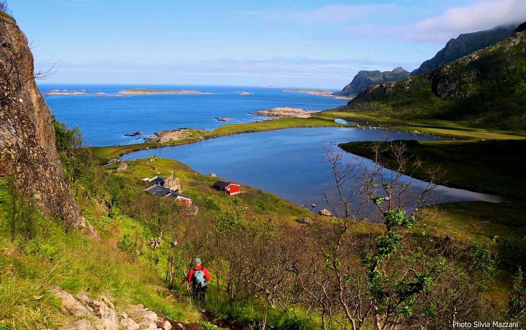
From the narrow notch should continue to descent reaching a broader quaint col with numerous signposts located below the top of Maelen. Here the paths diverge. Taking the left you will start to descend towards Nyksund along a path crossing a wide prairie and falling to join the last stretch of the road leading to the picturesque village after about 1 km. The digression is strongly recommended, though once you reach the village you need to come back and climb up on this same itinerary to return to the signposted col and resume the coast path to Stø. The digression will take you about one hour and a half, plus the time needed for an advisable visit in the village of Nyksund.


Once returned at the col, taking the path on the right, you will start to descend rather steeply, losing quickly altitude to get the stretch of trail running along the coast and going back to Stø. You will pass close to some red cabins nearby the sea.


Cross the isthmus beetween a wide lagoon and the ocean, then follow the wonderful path, crossing sometimes some wet terrain, aided by a few wooden footbridges.


After a wooden DNT shack along the shore, you will reach the superb Skipssanden sandy beach, just below the Kvalaksla summit ridge. Cross the beach and after a short ascent you will do the last steps on the path before getting the edge of Stø, then the village.
Essential Gear
The necessary equipment is the usual for hiking: boots for rugged, windbreaker, backpack, warm clothing and a waterproof jacket
Red Tape
There are no fees or permits needed to walk on Dronningruta.
When to hike
Summer is the best season.

Climate
Considering their situation well north of the Arctic Circle, Vesterålen have relatively mild winters and moderately warm summers; in fact the climate in the area is much milder than in other areas located at the same latitude. The average temperature in February, the coldest month, is around -2°, while the average temperature in July, which it is the month with the least amount of rainfall, is around 12°-14°. Fall is the wettest season.


In December and parts of January, the sun does not appear above the horizon, on the contrary the sun never plunges below the horizon during the period going from 23 May to 23 July. Anyhow the weather in Vesterålen can be extremely changeable. Even when the forecast is good, wet and windy intervals may occur.
Vesterålen climate info here:
Accomodation


***Niksund
- Holmvik Brygge: is situated on the smallest island at Nyksund. - Livskraftverk: offers accommodation in a holiday apartment. Situated just outside central Nyksund
***Stø
- Stø Bobilcamp: offers spaces for Mobile homes - Fishermen cabins available in central Stø
About Free camping
On Vesterålen - as usually in Norway - free camping is allowed if not expressly forbidden. Be aware that Vesterålen are a chain of windy and exposed islands and this factor must be considered with attention, seeking sheltered places.