
|
|
Route |
|---|---|
|
|
63.05790°N / 150.8932°W |
|
|
Mountaineering |
|
|
Spring |
|
|
Expedition |
|
|
Overview
This seldom climbed route (Buttress South Face), suggested originally by Bradford Washburn in 1962, offers enjoyable technical climbing challenges lower on the mountain and an opportunity to escape the crowds on the western side of the mountain.
East Buttress History
1963- The first ascent by W. Blesser et al. of a the route proposed by Bradford Washburn by the Teton guides.
1969- An expedition ascended the buttress via "Catacomb Ridge" (a spur leading to the east ridge).
1977- Our 2nd ascent ascent of the buttress south face followed the Bradford Washburn route used by the first ascent.
1978-1980 There were two unsuccessful attempts (1978 & 1980).
1981- Third successful ascent and two unsuccessful attempts
1982- Fourth successful ascent by Bill Krause et al. and one unsuccessful attempt.
1986- Fifth successful ascent by George Bell Jr. et al.
1987-2017 Seven unsuccessful attempts: 1987, 1992 (2 attempts, including helicopter rescue from buttress), 1993, 1994, 1996, and 2005.
This list may not be complete, especially since I have not researched approaches to the buttress from the north. If you are aware of other ascents of the buttress please contact me so I can include them in this list. I am also not aware that any party has bothered to walk up the mound to the actual summit of the buttress, so technically the actual East Buttress, which is listed as a separate peak, is still unclimbed.
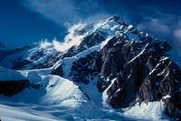
View of the East Buttress from the NW Ruth Glacier
Getting There
Just as for routes on the west side of Denali, Fly to Anchorage and take the Alaska Railroad to Talkeetna. Charter a ski equipped Cessna to fly you as close to the buttress as possible. The park boundary runs close to the base of the buttress so if the conditions are good an experienced pilot can land you within about a mile of the base of the buttress. We were landed by the Sheldon mountain hut, west of Mt. Barille, several miles down the glacier.Route Description
This route offers significant climbing challenges, including segments of steep ice and negotiating a safe route past crevasses and seracs. My impression is that the hazards and difficulty of this route are extremely changeable. During our ascent there were two major crevasses between Camp I and Camp II, but both had thin bridges that were negotiable. The seracs over the route appeared relatively stable and unlikely to fall, however between the time that we summited the buttress on July 11th and when we returned to descend it on July 19th, there had been major avalanches down the chute in the middle of the buttress' south face to the left of our ascent route. We actually chose to spend about a half hour in that chute in descent to avoid down-climbing the icefall that we had ascended above Base Camp. Climbing the ice fall above Base Camp avoids the chute to the left that drains probably the most active avalanching from the buttress south face, but it involved at least one pitch of very steep (70 degree) ice. The buttress between Camp I and Camp II was broken by two large crevasses that extended across the entire ramp up the buttress, except for thin bridges. If those had not been there the alternatives included much climbing and traversing on steep ice. I question whether our expedition would have been successful if the crevasses were not bridged. Above Camp II there was a large overhanging serac which was worrisome. Digging in Camp II revealed chunks of ice, indicating that when there is a fall from that band the debris carries on to the shoulder where the Camp was placed. That band of seracs was passes on the right on steep (60 deg) solid ice. Above that the angle drops off and then steepens as it passes the rocks near the crest to the left on a extended smooth 45 degree slope to the crest. The composition was a couple of inches of aged snow over ice, which was easy to kick step in, but hard to drive snow picket into. I stayed well away from the edge on the right after passing the rocks to avoid suspected cornicing, which was revealed after summiting the buttress.The route to the summit, following the ridge surrounding Thayer Basin was relatively straight forward, except for passing rocks on the ridge to the right, which put us on very steep snow, possibly prone to avalanching.
Descending the buttress was relatively easy, using the fixed 3/8" polypropylene lines, leaving snow pickets behind as rappel anchors. The lines from the crest had been buried slightly in snow, but were easily pulled out for rappelling. We recovered the lines from the lower angle sections, but left the lines over the steepest long sections. I had some trouble with the lower crevasse, as I didn't place the anchor in line with the bridge, which couldn't be seen from above, and had to rappel into the inside lip of the crevasse and climb back out. Descending during the day there was some trouble with our crampons balling up with snow, leading to uncontrolled sliding.
It is interesting to note that this route is not being attempted anymore (since 2005). My impression is that the long list of unsuccessful attempts since 1986 (30 years!) have discouraged further attempts. I would recommend a reconnaissance of ice and crevasse conditions on the buttress before seriously considering an attempt.