
-
 46750 Hits
-
 87.76% Score
-
 25 Votes
|
|
Mountain/Rock |
|---|---|
|
|
36.00106°N / 93.29384°W |
|
|
Newton |
|
|
Trad Climbing, Sport Climbing, Toprope, Bouldering |
|
|
Spring, Summer, Fall, Winter |
|
|
1400 ft / 427 m |
|
|
Overview
Horseshoe Canyon Ranch (HCR) is a relatively new climbing area in the heart of the Ozark Mountains of Arkansas. Limestone crags are the attraction to this sport climb Mecca where you can challenge yourself on over 250 routes from 5.5 to 5.13d. Most of the routes are sport (bolted), but there are a few nice cracks, trad lines, and bouldering. The thing that people most like about HCR is that it is very well bolted with few run-out routes. In fact, some think that it is over-bolted. However, remember most people who climb at HCR are from Missouri, Arkansas, and Oklahoma where the routes are somewhat sporty and run-out, so a route with a lot of bolts is somewhat of a novelty. Anyway, along with plenty of harder routes, Horseshoe has over 60 moderate (5.8 or less) lines which offer the beginning leader an outstanding opportunity to gain confidence.
Top-roping is allowed; however, routes must be led first in order to set up the top-rope. Walking along the top rims of the cliffs is not allowed. Many of the route's top-rope anchors are fixed just below the rim anyway and not inaccessible from the tops of the cliffs. Please do not run your top-rope directly through the anchor rings. Instead, use opposing locking carabiners attached to the rings to set up your top-rope.
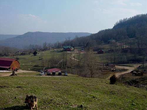
The climbing areas are located within the property of the Horseshoe Canyon Guest Ranch which is a full service dude ranch offering horseback riding, frisbie golf, accomodations, and other recreational opportunities.
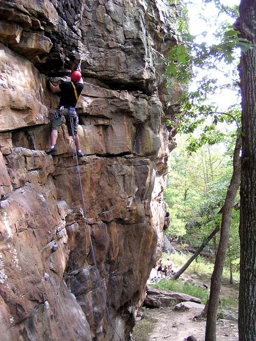
Barry Raven leads Green Goblin 5.8
Getting There
Horseshoe Canyon is located in northwest Arkansas. From the south via Interstate 40, drive 65 miles north on state highway 7 to the little town of Jasper. Drive through Jasper to the northeast side of town. Immediately after the bridge over the Buffalo River, turn left (west) on state highway 74. At the highway 74 turnoff, you will also see a green sign that says "Ponca" which indicates a left turn. Drive the twisty highway 74 for 7.4 miles until reaching the Horseshoe Canyon Ranch sign.
From the north or west, the goal is to get to the little town of Ponca, Arkansas via either highway 74 or highway 43. Once at Ponca, go east on highway 74 for approximately 6.5 miles until reaching the Horseshoe Canyon sign.
At the sign, turn south on a dirt road for about 3/4 mile until reaching a gate. This gate is usually closed (but not locked) to keep the livestock in, so please close the gate after you pass through. After the gate, go downhill for a half mile until reaching the Trading Post. All climbers must check in at the Trading Post.
Note: The dirt road leading into Horseshoe Canyon can get very muddy. It is also somewhat steep in places. Passenger cars normally do not have any trouble negotiating the road, but beware of steep and muddy sections after heavy rain.
Climbing Areas
The climbing areas are very close to the camping and parking and require only a 5-10 minute approach. As you arrive at HCR, you will see the bluffs rising above the valley to the east and west. There are 16 climbing areas with over 250 routes.
The more popular areas are: North Forty, Confederate Cracks, Prophecy Wall, Goat Cave, Land of the Lost, Middle East, and Roman Wall. Click on the map to get a nice overview of the climbing areas. Click this map to enlarge.
Here is the Horseshoe Canyon Climbing website: www.climbhcr.com
Guiding is also available at: www.GoHCR.com
Red Tape
Horseshoe Canyon is on private property. A $5.00 per day per person is payable at the Trading Post. There is a sign-in sheet and money drop box on the Trading Post porch if the Trading Post is closed. A liability waiver must be filled out and signed for all first-time climbers.
Private property surrounds Horseshoe Canyon and is off limits to climbers (or anyone else).
Please do not disturb the livestock (horses, cattle, goats) on the property.
No pets allowed.
No camping except in designated campgrounds.
VERY IMPORTANT: Newton County (where HCR is located) is a dry county. This includes the towns of Jasper and Ponca. So, be sure to stock up before leaving home if you wish to partake in after-climbing liquid refreshments. No alcohol allowed at the climbing areas.
Along the dirt road, just outside the Ranch, Coyote Campground offers year-round camping with showers and toilets.
The National Forest has two campgrounds at Kyles Landing and Steel Creek, both a short distance along highway 74 before reaching the Ranch road.
A commercial RV park is located in Jasper which will accommodate a full size RV or travel trailer and also has cabins to rent: Dogwood Springs RV Park
Several hotels and bed & breakfasts can be located both in Jasper and Ponca, Arkansas.
The Trading Post has snacks, t-shirts, basic climbing gear, and guidebooks, and is usually open seven days a week.
![]()

You can also order the guidebook at www.BostonMountainPress.com
No camping except in designated campgrounds.
VERY IMPORTANT: Newton County (where HCR is located) is a dry county. This includes the towns of Jasper and Ponca. So, be sure to stock up before leaving home if you wish to partake in after-climbing liquid refreshments. No alcohol allowed at the climbing areas.
Camping and Lodging
Camping is available at Horseshoe Ranch for $7.00 per day per person. There are two camping areas available on a first-come first-served basis. No showers available at the Ranch for primitive campers. Cabins are available during the dude ranch off season (August - March). In summer (dude ranch season), cabins may be available if they are not totally booked with dude ranch guests. Call or email for availability and pricing and tell them you are a climber to get the "cabin only" rate and not the "dude ranch" rate. Cabins sleep four people and have showers and cooking facilities, and include access to the hot tub and other Ranch amenities. Click here for cabin information and reservations.Along the dirt road, just outside the Ranch, Coyote Campground offers year-round camping with showers and toilets.
The National Forest has two campgrounds at Kyles Landing and Steel Creek, both a short distance along highway 74 before reaching the Ranch road.
A commercial RV park is located in Jasper which will accommodate a full size RV or travel trailer and also has cabins to rent: Dogwood Springs RV Park
Several hotels and bed & breakfasts can be located both in Jasper and Ponca, Arkansas.
The Trading Post has snacks, t-shirts, basic climbing gear, and guidebooks, and is usually open seven days a week.
Weather and Conditions
The ideal time to climb at Horseshoe Canyon is spring and fall. Summer can be unbearable with the heat, poison ivy, and insects. However, the North Forty is mostly in the shade while the eastern and western walls are in full sun. Winter can be dreadfully cold, but can also have some mild days. Check the weather before departing in the winter, because it can be 60 and sunny one day, and 20 and snowing the next.Guidebook
A new guidebook, Horseshoe Canyon Rock, was recently released by veteran climbers Tom Hancock and Chad Watkins. This is an excellent reference for Horseshoe Canyon climbing and is a must to fully enjoy the area. The guidebook is available at many local outdoor gear retailers or at the Trading Post at HCR.You can also order the guidebook at www.BostonMountainPress.com