
-
 22934 Hits
-
 74.01% Score
-
 4 Votes
|
|
Route |
|---|---|
|
|
20.08598°N / 155.7175°W |
|
|
Hiking |
|
|
Spring, Summer, Fall, Winter |
|
|
Most of a day |
|
|
Moderate |
|
|
Overview
The shortest approach I could find and possibly the only one possible without trespassing is from the Kohala Mountain Road west of Waimea.Park on the wide shoulder across Hwy 250 from the Koaia Tree Sanctuary at mile post 5.6
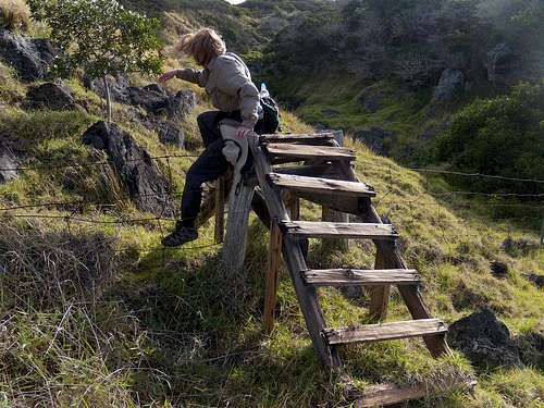
There are two options: 1): Cross the fence a few feet uphill on the wooden stile and follow Waiakamali Gulch the two miles uphill to the fence at the edge of the forest. (This is a more difficult way, but scenic in a unique way and somewhat out of the relentless wind you will likely encounter.)Thanks goes to Summitpost's own Herr Klenke for noting the stile and possible route and telling me about it after his trip to the Big Island in 2007.
There are a couple of spots where this canyon route becomes somewhat choked with vegetation so you may have to climb out of the canyon to bypass those spots.
The stile at the edge of the road:
Or, 2): Take the 4 WD track through the gate to the right of the Koaia Tree Sanctuary and follow it to the fence near the red gate. This track appears to be public access to the forest reserve for hikers and hunters and all gates were open along it as of December, 2009 - (except the one at the highway, which was closed but not locked.) The area to the east across a fenceline is posted as Parker Ranch property and no trespassing signs were evident. There were no postings anywhere on the routes described here on the day of my visits 6/9 and 6/10, 2008 and again on 12/3, 2009. Another note: You could head directly to the fence from the top of the 4 WD track and enter the forest through the red gate (see map) but that way is longer and decidedly muddier/boggier/trying.
Once at the head of the gulch, follow the fenceline northwest along the forest edge until you encounter a wooden stile. (Less than ½ mile west of the head of Waiakamali Gulch.) Cross the fence on the stile and head through the forest, following the blue ribbons on a 52 degree heading. In about 4/10 mile the trail splits east and west: Take a right and in a few feet you will find a cliff with a steep track on the left. If you are lucky, you can see Kaumu o Kaleihoohie a half mile away across the saddle. If you are engulfed in mist and clouds, (a more likely prospect) stay on your 52 degree heading, more or less. The route meanders a bit across the marshy meadow in the saddle and then resumes the original heading. The summit is a dense forest, deeply carpeted in moss, and without much of a view. Summit coordinates are: 20.8598 N , -155.71750 E. (more or less)
Published elevations disagree for this summit but an older USGS maps gives it as 1,678 meters which is lower but close to the figure I got on my GPS so I will use that: 5,505'.
Some maps show a couple of trails leading into the area from the west and passing within a mile and a quarter north of the summit. This may be a viable route but would be over triple the distance as described above.
Once across the fence at the forest boundary you are in the Pu’u Forest Reserve and here are the rules:

The rules of the forest
Another note: If engulfed in clouds you could miss getting to the true summit area on this hike: A few hundred yards from the actual summit the trail flattens out for awhile and then drops downhill slightly before rising very steeply to the actual high point. There are a couple of metal poles standing near the summit and a little farther to the north is a ~ 2" dia. metal pipe just barely sticking out of the ground that looks like it may have once sported a benchmark.
Be careful to follow the correct route back out! - There are at least three blue-flagged routes leading in different directions from the summit area so a compass and/or GPS is useful for this hike.
Getting There
See the "Getting there" section on the main page.Route Description
This is a route up an open meadow with great views of the other three major Big Island peaks: Mauna Kea, Mauna Loa and Hualalai. It will be windy!Essential Gear
Sunscreen, more sunscreen, did I mention sunscreen? - Even on a cloudy day you will get cooked - it's just that way in Hawaii.Have a light rainjacket, wool socks in good high topped shoes or boots and expect to get soaked - either from the rain, the vegetation or the mud pits, bogs and general wetness of the area. The good news is that there are no mosquitoes at this altitude in Hawaii!! (You may see a spider or two but they are not much of a problem). Temps will be in the 60's in the afternoon and the fifties in the morning pretty much year around.