
-
 3570 Hits
-
 85.87% Score
-
 21 Votes
|
|
Route |
|---|---|
|
|
43.53090°N / 5.58043°E |
|
|
Trad Climbing |
|
|
Spring, Fall, Winter |
|
|
Most of a day |
|
|
French scale 5a |
|
|
5.6 (YDS) |
|
|
15 |
|
|
Overview
Les Moussaillons + Arête du Jardin + Arête SW
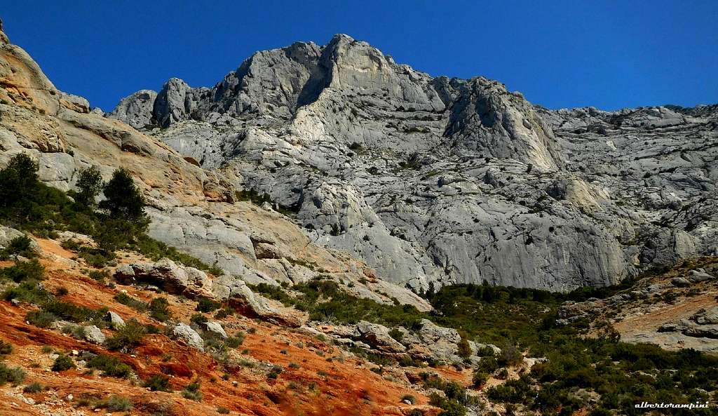
To the South the Montagne Sainte-Victoire appears as a huge rocky bastion with a 7 km long summit plateau and different summits lined up along its extended summit ridge. Starting from the West (from the left looking at the wall from the road D17 running below) the first important summit is the Croix de Provence 946 m, well identifiable by the presence of a very high cross on the top. A perfect area for walking, but even more to climb. Montagne de Sainte-Victoire is really a wonderful world of stone, therefore it's a great drawn for climbers, due to the amazing limestone, the plenty of routes on all the summits, the beauty of the landscape. The rock climbing destination at Sainte-Victoire is the South face, which counts around 1000 routes, 29 or more sectors and 7 separate parking lots, an astounding space to climb up a surprisingly sticky Limestone.

|

|
A beautiful way to climb up to the Croix de Provence is a logical combination of three routes sequentially linked that leads to the top from the base of the wall with a 400 m difference in level nice climb. Often attended, this route offers a full day of classic climbing in a beautiful setting.
Getting There
By plane - Sainte Victoire massif is situated 35 km from Marseille and 180 km from Nice, so the best option is to fly to Marseille or Nice and rent a car.
By car - The nearest town is Aix-en-Provence. The A8 autoroute runs South of Sainte Victoire and Aix-en-Provence. If coming from the Nice direction, exit the A8 onto the RN 7 in the direction of Aix. From Aix, take the "Route de Cézanne", road D17, which traverses under the South side of the massif from Les Tholonet at the Western end to Puyloubier at the Eastern one, passing across Beaurecueil and St. Antonin. There are several parking lots along this road, from which we can approach the various climbing sectors. The starting parking to climb the route described below is the parking lot of En Chois.
Red and white on Montagne de Sainte-Victoire
Route report
Les Moussaillons + Arête du Jardin + Arête SW report (French scale)
Summit altitude: m. 946
Difficulty: 5a max (French scale)
Equipment: pegs
Climbing length: 400 m
Exposure: South
First ascents: Les Moussaillons: Bernard Amy, Alain Michel 1965 - Arête du Jardin: Henri Gentil - Arête SW de la Croix: Marc Latil, Louis Paul 1941
Starting point: Parking Plan d'En Choise
An advisable combination of three fine ridges with a reasonable level of difficulty, where it's important to know how to place the protections to integrate the existing ones in place. The walking transfer between "Les Moussaillons" and "Arête du Jardin" cuts a little the course, but actually doesn't disturb the interest of climbing.
Approach
From the Parking Plan d'En Choise or the adjacent Parking Bouquet, also named Parking Cézanne, located on the road D17 before the hairpins when coming from Beaurecueil, follow the forest road that leads to the refuge Cézanne. After the first bend, leave it and take the red path leading to the Refuge Cézanne. From the refuge take on the right the brown path and follow it traversing below the foothills of the Croix de Provence and getting to a saddle within 10 minutes. From there locate a characteristic square block and rise towards a terrace below a characteristic reddish slab.
Les Moussaillons report
L1 - Climb the fine reddish slab built in conglomerate rock, at first directly, then slanting left and ultimately with a left traverse to gain the belay (bolts and holes), 5a, 25 m
L2 - Slightly to the left of the stance climb a short crack, then directly to a terrace. Belay on a tree, 4a, 20 m

|

|
L3 - Right above the stance on a small wall, then move left to reach a second steepest wall engraved by two cracks. Up the left one to a terrace, 4b, 20 m
L4 - Climb a white slab to get an equipped belay, 4a, 25 m.

|

|

|
L5 - Slanting left to a big pine, belay on the tree, 4a, 35 m
L6 - Climb on the left the small needle above the tree and pass a notch. Belay on shrubs on the shoulder, 3a, 35 m.
From here follow the cairns to the left (North, then West), when the trail starts to descend, leave it and climb up a short wall, giving access to the upper terrace. Follow the cairns to reach the base of the Arête du Jardin, the ridge that descends to the left in line with the summit Cross. Locate this obvious ridge that runs to the left and ends at the foot of the SW wall of the Cross. Starting point on a terrace with a small tree.
Arête du Jardin report
L7 - Climb the slabs, then reach a notch with a hole, 3c
L8 - From the notch up a short wall, then definitely to the left of the ridge to reach a dihedral. Climb it and belay above, 4a
L9 - L10 More easily up the ridge, getting the base of the last rocky head of Arête du Jardin
L11 - Climb the rocky head, then on easier terrain get the equipped belay at the start of the third part of the route, Arête SW de la Croix de Provence.

|

|
Arête SW de la Croix de Provence report
L12 - From the belay climb up the obvious smooth wire of the ridge (some pegs in place) to a belay below a system of dihedral-cracks, 4c, 30 m L13 - Climb the cracks-system and belay on a tree, 4c, 30 m L14 - Up another dihedral and thin cracks to another belay on a tree, 4a, 25 m L15 - The last easier length exits just below the huge cross.

|

|
Descent From the cross, turn left on the path marked with white-red signs (GR and reach the Prieure. At a fork leave the GR and follow the Blue path, getting a cairn where you must leave also the blue path and follow leftward the red marks of the Pas du Moine path, descending steeply. After a short downclimb the path descend more gently to the Refuge Cézanne, where the descent joins the path followed during the approach.
Red Tape
No fees, no permits required and no restriction from October to May, while the access to Sainte-Victoire is strictly regulated from June 1st to September 30th to avoid any risk of fire. Indeed, during the summer months, due to the heat, the climate-dryness and the intense sunshine, the fire hazard is very high. The restriction depends on the weather condition. You must call the day before 18:00 on 08 11 20 13 13 to know the conditions of access or visit the site Niveau de Danger Feux de Forêt. There are 3 levels of forest fire danger: the Orange level (you can hike), the Red level (you can hike between 6am and 11am in the morning and the Black level (the hike is forbidden under penalty of fine). Wild camping is of course also forbidden.

|

|
When to Climb

In addition to being strictly reagulated from June 1st to September 30th to avoid any risk of fire, as told in the previous chapter, climbing in summer is not advisable in reason of the excessive heat. You can climb also during the winter, but sometimes the weather can be cold and windy, so the best periods are Spring and Fall.
Camping

There are different places to stay close to Montagne Sainte Victoire. We can find equipped campsites in Puyloubier, Beaurecueuil, Rousset and Peynier:
- Camping Sainte-Victoire (Beaurecueil) - Camping Le Devançon (Peynier) - Camping Le Cézanne (Puyloubier)
Alternatively Gites and hotels are available in St. Antonin and Puyloubier.
Meteo
Meteoblue Montagne Saint Victoire
Guidebooks and maps
 |
 |
New "Escalade en pays d'Aix" Daniel Gorgeon and Philippe Légier - Ed. Nota Bene, 320 pages, last edition: 2015
"Escalade Sainte-Victoire" - Daniel Gorgeon and Philippe Légier - Ed. Nota Bene
map IGN - 3244ET - Montagne Ste-Victoire - Aix-en-Provence - Gardanne - Trets