In Search of the Devil
Back in the winter of 1999-2000, while planning out my first solo summer trip to Wyoming, I was reading Bill Hunger's Hiking Wyoming and came across a backpacking trip that really got my interest: Frontier Creek in the Absaroka Range.
About 25 mostly unpaved miles from the closest town, the trailhead is remote to begin with. Then the trail begins with a stream crossing that for much of the summer is not going to please most people. Seven miles up the canyon is a challenging stream crossing if one wants to take a little-used trail up to a high pass (Cougar Pass) and beyond. Past that junction the trail largely goes to hell, though it is tolerable until 9 miles (while also passing a petrified forest on the other side of the stream), and then a pretty miserable 2 miles (ups and downs on game trails at best across numerous avalanche chutes) will get you to an amazing alpine lake basin that due to its beauty and remoteness has got to be one of the best settings in the U.S. Rockies (many of these details are from my experience and not found in the book, by the way).
But the real eyebrow-raiser in the description was Hunger's mention of an old outfitter trail leading to a high, lonely location known as Devils Graveyard because of its numerous flat, headstone-like rocks naturally set at angles perpendicular to the ground.
Instantly, I knew I had to find that spot. Adding to the allure was the fact that Hunger writes that multiple attempts on his part to locate the old trail have failed. So then there was the prospect of being somewhere that literally only a handful of people have seen over the past few decades.
As is so often the case, though, I got sidetracked. Other hikes and climbs seemed better for the particular trip, whatever the year. After that initial inspiration, it wasn't until August 2011 that I finally made myself commit to the journey up Frontier Creek to find Devils Graveyard and climb unnamed peaks in territory almost as remote as it gets in the Lower 48.
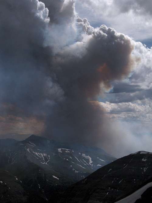
Nature had a different plan: fire. That summer, there was a big fire in the Southern Absarokas. Although Frontier Creek wasn't touched, surrounding areas were, and the Forest Service closed the trails. Despite doing several fine climbs instead, I was terribly disappointed by not having been able to fulfill that old objective.
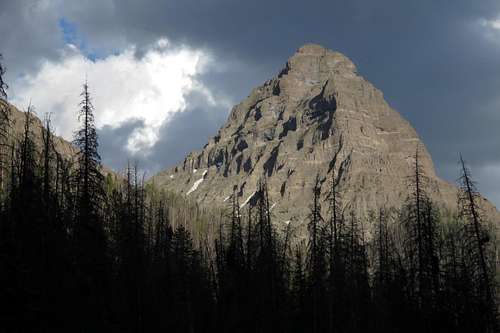
![Wiggins Peak and Wildfire]() Wiggins Peak and wildfire-- 2011. Wiggins is in the general vicinity of Frontier Creek.
Wiggins Peak and wildfire-- 2011. Wiggins is in the general vicinity of Frontier Creek.2014-- good snowpack from the winter, relatively wet summer even though I was lucky enough to catch what turned out to be one of the sunnier and drier stretches of the season. Little chance of fire problems.
A plan.
Execution.
Trailhead
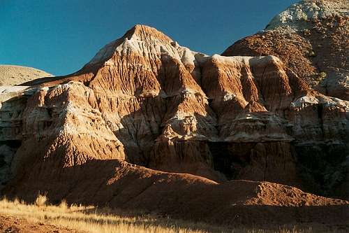
If the closest you ever get to Frontier Creek is driving to the trailhead, it's still worth the trip. After you leave the residential area of Dubois behind, the scenery opens up and never relents. First it's the Dubois Badlands, and then it's the mighty Absarokas.
![Dubois Badlands]() Dubois Badlands
Dubois Badlands
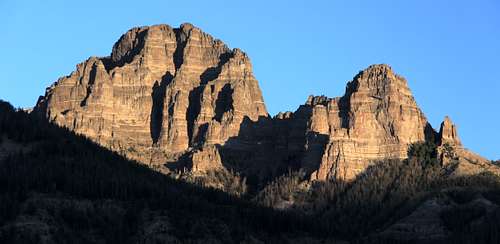
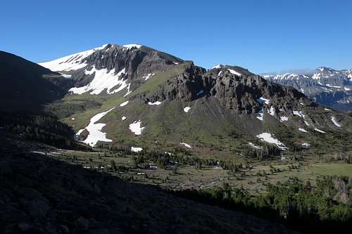
![Southern Absarokas]() Southern Absarokas
Southern Absarokas
| ![Southern Absarokas]() Southern Absarokas
Southern Absarokas
|
Just the trailhead itself is unforgettable, with mountains almost completely encircling you.
Despite deferred plans and thwarted ones, I'd actually been there twice before. In 2001, on a day between backpacking trips, I hiked up Frontier Creek to the junction with the trail to Cougar Pass. And in August 2013, my wife, kids, and I went out there for a day just to mess around (while I studied a potential route up one of the peaks).
Late in the afternoon, I got to the trailhead, which surprisingly was pretty crowded with campers. As is my wont, after eating and then taking some pictures before sunset, I stretched out in the car, had a few beers while watching a movie on my tablet (nothing like getting back to nature in the wild), and went to sleep.
In the morning, I got to enjoy the view in the other direction:
![Dawn from Double Cabin TH]() Dawn from Double Cabin TH
Dawn from Double Cabin TH
Also the next morning,
Tim arrived.
Tim lives in Wyoming and I live in Virginia, but we became acquainted through SP, and every summer since 2009, we have gotten together to climb. Our climbing styles and preferences differ, and we only infrequently keep in touch outside the climbing days, but I think we have become pretty good friends through shared experiences and viewpoints, both mountain-related and not.
After checking our packs, taking special care to make sure we had plenty of beer to sink in the river and chill after setting up camp, we set out.
Camp and Cougar Pass
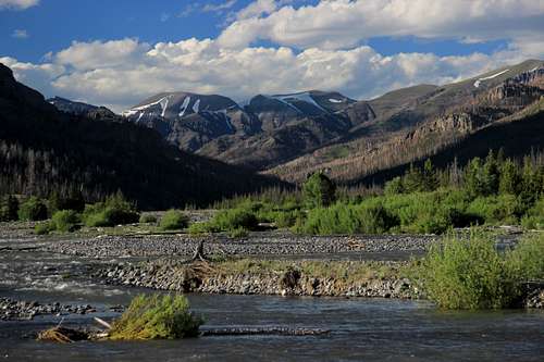
Once you cross Frontier Creek, and conditions can force you to spend some time finding the best place to do so, you feel you have crossed a boundary between the known and the wild. Ahead of you are dozens of miles until the closest road. One could get lost out there. One could spend a lifetime exploring all of it. We had but a few days.
We made camp maybe half a mile before the confluence with Cougar Creek, and almost directly across a meadow from where we figured the lower end of the old outfitter trail to be. Sheltered by trees but also right by Frontier Creek, the spot was perfect. Even a fire ring was present, eliminating the need to feel guilty about enjoying some flames as we drank beer after dark.
About an hour after making camp, I was feeling ready to do something. Tim wanted to save his legs for the next day, which had the potential to be a big one, and thus I headed off myself for Cougar Pass, which necessitated a sketchy stream crossing at the junction of the trails up Frontier Creek and to Cougar Pass.
Although it is an alpine pass, accounts I had read about obstructed views turned out to be correct; the pass itself is oriented north-south, not east-west as most passes in the Rockies are, and a high ridge just to the west blocked views of what surely were typically spectacular scenes of the southern Absarokas.
![View North from Cougar Pass]() View North from Cougar Pass
View North from Cougar PassNo matter-- it was good just to be there, and good to get a chance to play a bit with my new ice axe, as the last mile of the trail was almost entirely buried in snow. And the absence of any other signs of human passage virtually confirmed that I was the first person there that summer.
Plus, the hike back yielded some salivating views of Coffman Butte, a peak I must go back to and figure a way to climb:
![Coffman Butte at Sunset]() Coffman Butte at Sunset
Coffman Butte at SunsetThe Graveyard
About dawn the next morning, we got up, added some natural fire prevention to the vicinity, packed what we would need for the day, and set out. Picking one of the paths we had noticed going up the mountainside from the meadow, we started heading up but soon worked our way north (left) to where the old trail was more likely to be.
It was there, and in surprisingly good condition, making the rest of the way much easier, almost disappointingly easy, than we had expected it to be. Having experienced steep, ugly Absaroka bushwhacking before, Tim and I were expecting more of the same, but it didn't happen.
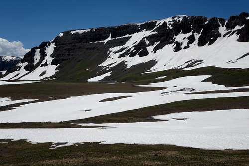
Near timberline, the trail reaches a pretty basin and disappears after dropping into it. If the trail ever went all the way to the mountaintop, it doesn't anymore, but it wasn't hard to find the way from the basin. Tim and I took different approaches as he wanted to find the trail again and I just opted for something more direct, but neither of us had any trouble.
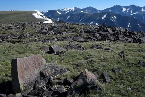
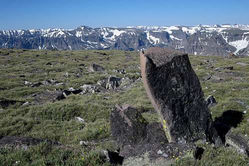
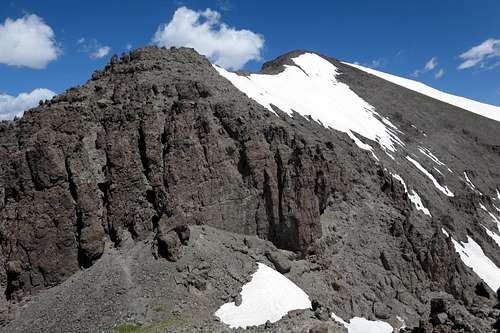
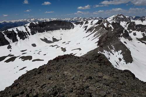
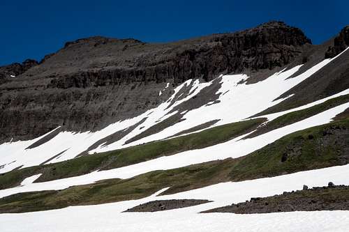
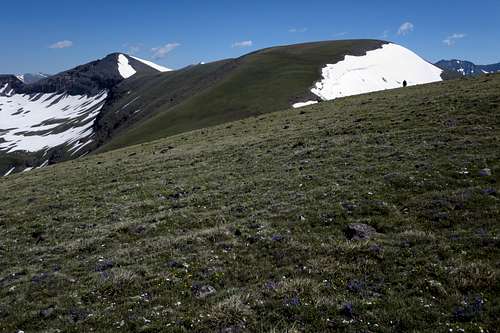
![Looking down into the basin where the trail disappears]() Looking down into the basin where the trail disappears. If you want to go to what the map calls Devils Graveyard, you can follow the drainage seen on the left.
Looking down into the basin where the trail disappears. If you want to go to what the map calls Devils Graveyard, you can follow the drainage seen on the left.Something of note: Tim had read or heard somewhere that the USGS topo map is wrong in that it incorrectly marks the site of Devils Graveyard. Tim's source was correct. The peak on the Emerald Lake quad labeled as Devils Graveyard is not the actual location of the site. Instead, the next peak north from it, an unmarked peak with an interpolated elevation of 11,580', is where you will find the stones.
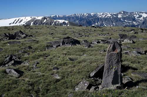
![False Devils Graveyard]() False Devils Graveyard
False Devils GraveyardAlthough we don't like to admit it, sometimes a climb or hike does not live up to the planning and waiting we put in and the image built in the mind.
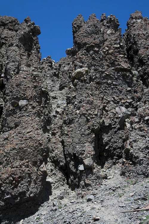
Such was not the case here.
It is a place with a distinct aura. Yes, the rocks really look like gravestones. Some look so much like gravestones that standing there, especially alone, is downright eerie. But they were not set that way by people. No one seems to know how they ended up the way they are, but the formations are natural. Yet you can't help but be a little quieter and be a little more alert, wondering if perhaps this place is the haunt of restless, malevolent spirits.
When Tim appeared, my gladness was from more than just knowing he had made it up safely.
It was way too early to head back and be lazy for the rest of the day. After discussing four options, we settled on this:
Heading north from Devils Graveyard to Peak 11,804, then to Peak 12,025, and from there down into the basin containing Green Lake and the headwaters of Frontier Creek. Following that, we would locate the upper end of the trail and return to camp.
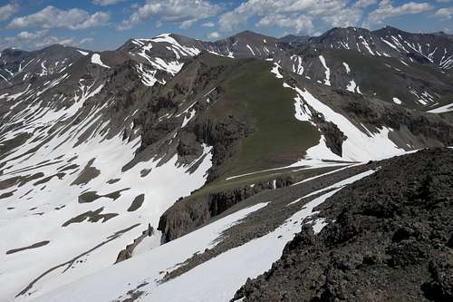
![Peak 12,025]() Peak 12,025
Peak 12,025This offered three distinct advantages:
- Tim is into lists and ranked peaks. Although he knows I'm not, he is still a good sport about my occasional ribbings over his need to "get" all kinds of unnamed bumps. This gave him a chance to tag two more ranked peaks.
- While I had little interest in the stroll up 11,804, I had for a few years had a strong interest in 12,025 for its remote position and, based on studying topo maps, my sense that there might be a fun route up it.
- By dropping back into the Frontier Creek drainage and returning to camp, we would cover the trip's principal objectives in a single day, leaving us with the option of heading out a day early in order to pursue different goals.
So we headed north along the easy but wonderful ridges, wonderful for their remoteness and their kick-ass views, traversing the unranked summits of Points 11,739 and 11,654 en route.
![Tim Headed to Peak 11,804]() Tim Headed to Peak 11,804
Tim Headed to Peak 11,804
| ![Tim Headed up Peak 11,804]() Tim Headed up Peak 11,804
Tim Headed up Peak 11,804
|
Although in most respects unremarkable, the broad summit of Peak 11,804 continued the day's theme of incredible views. Really, for just the views alone and for the sense of isolation, a day in the mountains really couldn't get much better than this one.
A Tangent: The Most Remote?
There is some debate about what is the most remote peak in the conterminous U.S. Regional bias probably plays a role, but the debate usually narrows down to somewhere in the North Cascades of Washington or to Younts Peak in the Wyoming Absarokas. As someone who loves the Absarokas above all other ranges, I side with Younts. :-)
Regardless, Younts is more than 20 miles from the closest road, and those roads are unpaved. Even if it's not the king, it's still pretty damn remote.
Many times, from many different peaks, I have seen it. Not once have I climbed it. One of these days, I will. But on this particular day, Tim and I agreed that the ridge between Devils Graveyard and Peak 12,025 had gotten us closer to Younts than we had ever been before. The picture below is not great since it is a full zoom from a point-and-shoot, but here behold the wilderness king of the Lower 48:
![Younts and Thorofare]() Younts and Thorofare
Younts and Thorofare12,025-- A Four-Year Goal
As much as they are known for their beauty, mountains also are known for throwing surprises in a climber's way, and our little surprise of the day came during the descent from Peak 11,804. From the summit to the saddle between the peak and Peak 12,025, there is a drop of 400', no big deal at all. Closer to the saddle, though, the contours get a lot closer, suggesting the possibility of something spicy.
Since much of Absaroka rock consists of a particularly crumbly breccia, spicy non-technical terrain in this range means exposed and very loose Class 3-4 going.
And this mountain delivered. All of a sudden, the gentle slopes gave way to steep, broken ground. Tim decided to look for (and found) a workaround. I decided to embrace the garbage.
I'd call the descent Class 3 in difficulty, though the untrustworthy rock gave more of a Class 4 feel. There also was just enough snow in just the right places to make me get my axe out.
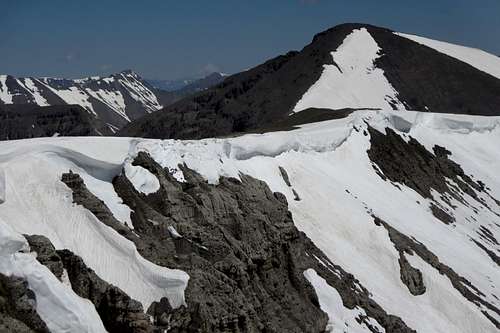
But even better than the unexpected fun on the descent was the view it gave me of the ways up 12,025:
![Peak 12,025 and Route Options]() Peak 12,025 and Route Options
Peak 12,025 and Route OptionsAt the saddle, I had a few minutes to myself as I waited for Tim to catch up; this allowed me to scout the next part of the route and also allowed me a memorable moment with a lone coyote moving across the snow 500' below near still-frozen Emerald Lake. For just a second or two, the coyote broke its trot and looked up at me with what I interpreted as a "What the hell is that and what is it doing up there?" glance, and then it continued on its way, soon gone from sight.
There were also some boot tracks in the snow on the Emerald Creek side, but not on the Frontier Creek one. Someone must have been up recently from Emerald Lake, and, climber or not, that was someone tough or on horseback, for the 12-mile hike to Emerald Lake requires at least six stream crossings; none of them are supposed to be easy, and the water was still pretty high at that point in the summer.
Just above the saddle is a chimney that heads directly up toward the false summit (left in the shot above), and that's the way I chose to head up. Tim didn't join me because he was hiking hurt to begin with and wanted a rest, and he was happy enough with what we'd already done that day and cognizant of the fact that we still had a good 5-6 miles back to camp.
![Class 4 Chimney]() Class 4 Chimney
Class 4 ChimneyAbout 80' of Class 4, the chimney was a fun climb on rock surprisingly good for the Absarokas. After it, there was some easy scrambling to the false summit and then even easier hiking the rest of the way.
For some reason, I can't remember if there was a summit cairn. I think I remember telling Tim that there was one and that I was disappointed to find it. While I have no doubt someone else had ever been up there before I was, I always find it depressing when people have seen fit to leave traces of their passage behind on remote, obscure peaks. Actually, I don't like cairns and registers on any peaks at all. To me, it is deflating to get that far from civilization only to be presented with an ugly reminder of it.
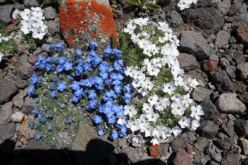
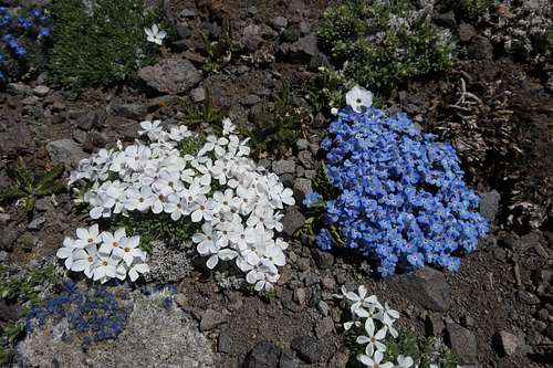
![Alpine Wildflowers on Peak 12,025]() Alpine Wildflowers on Peak 12,025
Alpine Wildflowers on Peak 12,025
| ![Alpine Wildflowers on Peak 12,025]() Posted to annoy those who hate wildflower pics ;-)
Posted to annoy those who hate wildflower pics ;-)
|
Regardless, what a peak! At about 37 miles from the nearest town and 30 from the nearest pavement, Peak 12,025 truly qualifies as remote. And it pays you back for the effort you put in to get there by serving up truly spectacular, unforgettable views of mountains in all directions.
And lakes.
Some of Greater Yellowstone's ranges are known for their alpine lakes; the Beartooths, Madisons, Tetons, and especially the Winds come to mind. Sculpted more by volcanism than by glaciers, the Absarokas do not. For such a vast range, and it is Greater Yellowstone's largest, it actually has very few lakes. And for reasons I do not know, the large majority of them are in the Southern Absarokas, especially if you don't count the Montana Absarokas, which geologically are quite different from most of the rest of the range.
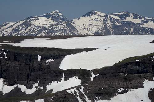
In the vicinity of Peak 12,025 are five significant alpine lakes: Green Lake, a higher lake just north of Green and part of the same drainage, Emerald Lake, Snow Lake, and Sheep Lake. The first three are visible from Peak 12,025.
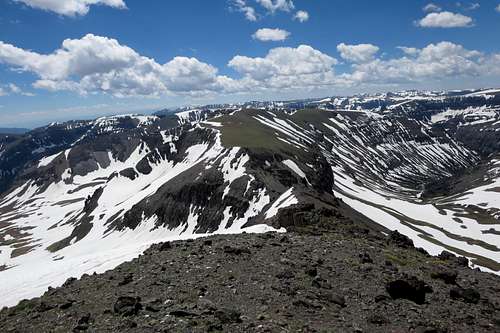
So the views...I've been talking about them almost all along, right? If it's true that you save the best for last, then I'm hoping holding off on showing the views until those from the last summit was the right choice. Here is a look if you face south and then do a complete turn clockwise. I hope you enjoy:
![Looking South from 12,025]() The ridge by whence I came
The ridge by whence I came
![Upper Frontier Creek and Green Lake]() Upper Frontier Creek and Green Lake
Upper Frontier Creek and Green Lake![Upper Lake Above Frontier Creek; Red Tops]() Upper Lake Above Frontier Creek; Red Tops
Upper Lake Above Frontier Creek; Red Tops![Red Tops and Needle Creek Drainage]() Red Tops and Needle Creek Drainage
Red Tops and Needle Creek Drainage![View NE from 12,025]() Unnamed splendor
Unnamed splendor![Emerald Lake]() Emerald Lake
Emerald LakeDown to the Headwaters
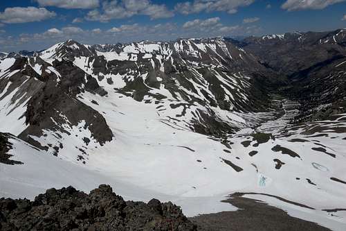
The saddle between 12,025 and 11,804 also serves as a link between two drainages: Frontier Creek to the east and Emerald Creek to the west. Although a rugged use trail supposedly goes from basin to basin via the saddle, there was so much snow about that any trail was going to be buried well into summer.
There are two alpine lakes in the basin that holds the headwaters of Frontier Creek: Green Lake and the higher one about half a mile north of it; they are not connected and instead feed different tributaries that soon converge in Frontier creek. Maps depict three other tarns in the basin, but they are not large enough to really qualify as lakes.
Green Lake was ice-free and its cousin wasn't. Since Tim and I had been able to see both lakes from the ridges and peaks above, we felt no real need to visit the actual shores, and thus the plan was simply to descend into the basin and hike south until we found the trail again. This would mean up to a mile into the basin, two miles back to the trail, and then two miles back to camp.
The descent was easy and fast, a mix of foot-skiing down scree and snow. Tim used his axe, and I would have used mine, but I had a conflict of interest: on the snow, I spotted a pretty large, beautiful spider that I knew would freeze and die if it found itself still on the snow that night. So I cupped it in my hands and kept it until I reached a large snow-free area where I could set it loose. Yes, I risked a fall or broken legs or worse to save a damn spider, and I don't care.
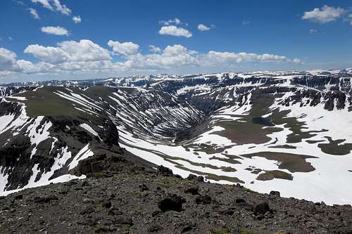
Of Peak 12,025, I said "What a peak!" Of the basin of Upper Frontier Creek, I say "What a basin!" For starters, it's rare enough to find lakes above treeline in the Absarokas. Even rarer is to find two significant ones so close to each other. And with all the snow still present, the basin only vaguely resembled typical Absaroka scenery and looked a lot more like Greater Yellowstone's glaciated ranges instead.
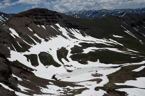
I'm too lazy to make a panorama of five separate photos, but here is a look about the basin if one is facing southeast and starts turning clockwise about 180 degrees:
![Basin Above Frontier Creek]() Peak 12,025
Peak 12,025And Back to Camp
With four miles still to go, we reluctantly began to descend the basin. This proved to be harder than we expected and actually was probably the hardest part of the day. At times, there was a use trail or a game trail to follow, but the lack of a good, consistent trail was not the problem. No, the problem was that the route crossed one avalanche chute after another, and the constant ups and downs became exhausting, at least for me; Tim had found his legs, but I had lost mine for whatever reason, probably because it was my first long hike since April. And going through avalanche chutes meant sometimes negotiating debris, with deep, soft snow around it to make things more difficult and dangerous.
As I've become more passionate (obsessed) about climbing and exploring, I've become less fond of trails. This day, though, I was glad when we finally got back on a real trail, for I really hadn't appreciated having to deal with all that crap terrain on the way down.
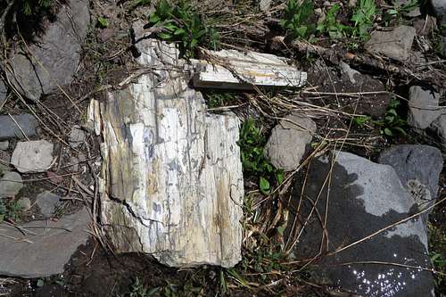
Despite that, the return hike was not without some pluses. About 8 miles up the Frontier Creek Trail, there is a petrified forest on the west side of the creek. It is very difficult to see any petrified wood from the trail, so if the creek is low enough, cross it and go check the site out. (Be aware that it is illegal to remove any petrified wood.) The creek was too high for us to cross, but we did spot a few specimens on our side.
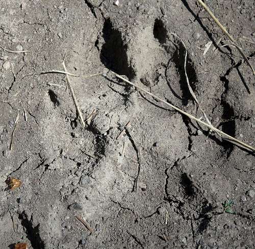
And we saw a wolf track. Too large to be from a coyote, it might have been from a big dog, but there were no other signs of recent passage by humans, dogs, or livestock anywhere on the trail, so it almost had to have been left by a wolf. Some in Wyoming rue that the wolves even exist; I rue that I have not yet seen one except through a spotting scope. I want to be much closer than that.
![Petrified Wood]() Petrified Wood
Petrified Wood
| ![Wolf Print?]() Wolf Print?
Wolf Print?
|
That night at camp, we decided to head out the next day. There were other peaks around Devils Graveyard we would have liked to climb, but neither of us really felt like retracing the approach route so soon. Very nobly, Tim helped me drink the rest of my beer so I didn't have to haul that extra weight back out. Then we got a hops-aided night's sleep, and early the next day we packed up and hiked back, pretty briskly since the mosquitoes were so damn awful. As it turned out, it was a classic win-win decision; Tim got home a day early, scoring some points with the girlfriend, and I got to go climb something I'd been meaning to for years, in the process perhaps becoming the first person to have climbed all five principal summits of the Pinnacle Buttes. While that won't make me rich or famous or irresistible to exotically beautiful women, I'll take it.
In those three days, we saw not a single grizzly despite being in the best habitat for them in the Lower 48. Yet I later saw two in a span of about 12 hours. You just never know out there in Bear Central. And you never know if you're glad or disappointed not to have seen the Great Bear. Usually, I'm disappointed; almost every time I have seen one, it's joined the list of life's greatest moments. Even
the time I thought my life was over, it was still exhilarating.
Comments
No comments posted yet.