
-
 6939 Hits
-
 75.81% Score
-
 6 Votes
|
|
Mountain/Rock |
|---|---|
|
|
28.01736°N / 15.61333°W |
|
|
Hiking |
|
|
Spring, Summer, Fall, Winter |
|
|
5814 ft / 1772 m |
|
|
Overview
 Los Moriscos seen from the base of Roque Bentaiga Los Moriscos seen from the base of Roque Bentaiga |
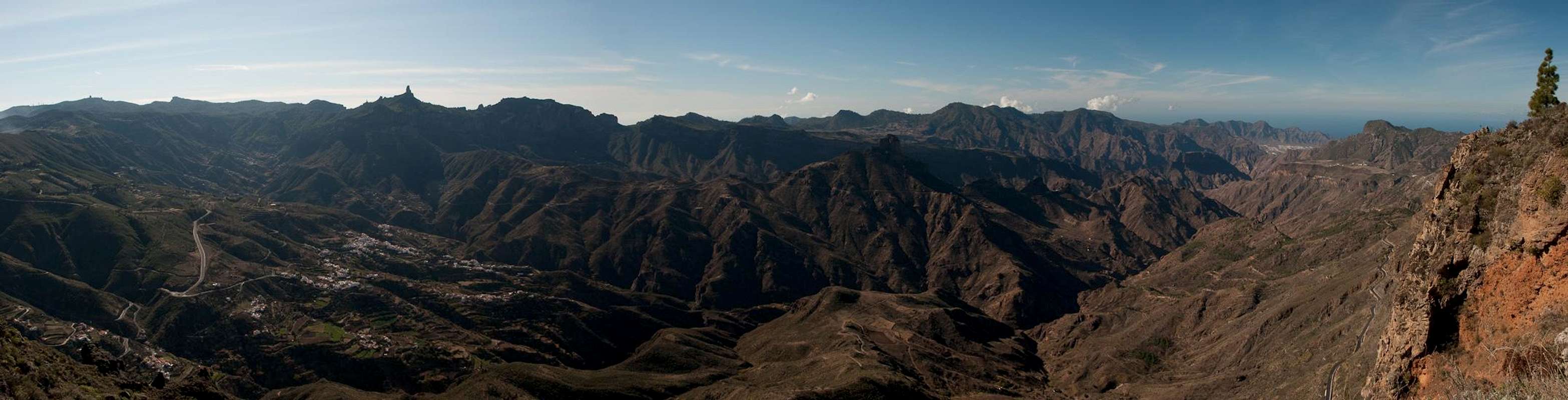
Caldera de Tejeda is one of the largest erosion craters on the Canary Islands. Right after the Cañadas del Teide on Tenerife and Caldera de Taburiente on La Palma it is number three, directly followed by Caldera de Tirajana on the opposite side of Gran Canaria's central mountain range, the Cumbre Central. It is the crater left over from the original volcano, which created Gran Canaria, millions of years ago. The crater is huge and bounded by impressive walls, mainly to the north and the west. Erosion has taken its toll and opened an outlet to the Atlantic Ocean in the west, where in present day you can find the coastal town of San Nicolas de Tolentino.
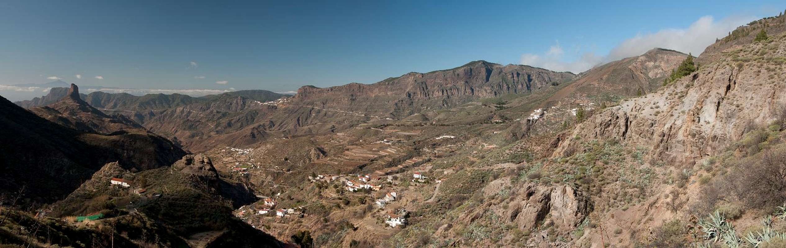
The crater stretches from east to west with the central circular part in the centre of the island. The western part narrows into a narrow gorge, the Barranco de San Nicolas. On its northern side the caldera is bounded by a long wall of several hundred metres height, which runs from the saddle Cruz de Tejeda to Altavista before dropping towards the sea near the town of La Aldea. On this ridge of 15km length there are several summits, the highest of which is called Los Moriscos (el morisco: the converted Christian inhabitant of Spain and Portugal of Muslim heritage). The ridge traverse of the whole (or only parts of the) crest is one of the great undertakings on Gran Canaria. You stay high above the massive walls of the caldera with wonderful views across the wild landscape.
 |  |  |
The ridge is part of the weather divide of the island. To the north and east the trade winds deposit massive amounts of moisture while rising towards the mountain tops while the west and south are dry and arid, almost desert-like. Often cloud caps develop above the crest and turn a wonderful hike into a complete whiteout with visibility of only a few metres. Los Moriscos, as the highest point of the ridge, often stays (barely) above the clouds while the access trails get soggy.
On the western slopes of Los Moriscos, carved into its south face you find the Cuevas de Caballero. The caves were carved out of the soft soil several centuries ago and have been sanctuaries for local shepherds and their flocks ever since. They are located on a tiny balcony in the south face of Los Moriscos, hundreds of metres above the caldera floor. They can be reached from the ridge above by a short but slippery trail. Today they have been declared "culture monument" and have been closed with iron bars. Still you can visit the balcony and enjoy the wonderfully airy view of Caldera de Tejeda.
 |  |  |
From the north a surprisingly dense pine forest reaches up to Los Moriscos. Several trails meet close to the summit, on which a radio antenna has been erected. One of these trails, coming up from the north heads across the area of the latest volcanic eruptions on Gran Canaria, which occurred 3000 years ago. Here the black cone of Montañon Negro rises above Gran Canaria's largest volcanic crater, Pinos del Galdar. The hike along this ridge is also a very popular tour on the island.
Panorama Caldera de Tejeda
  |
Getting There
Gran Canaria can be reached from any major European airport. Usually charter carriers fly there but the spanish airline Iberia has also regular flights. The airport is on the eastern coast of the island, far away from the tourist centres in the south.The most reasonable trailhead for Los Moriscos is the road crossing Cruz de Tejeda. There are restaurants and souvenir shops as well as a big parking lot there.
- From the south
- From Maspalomas take GC60 through Fataga and San Bartolome to the saddle Cruz Grande
- From the saddle stay on GC60 until you get to Ayacata.
- Still stay on the road which winds toward Tejeda
- After Tejeda switch to GC15 to Cruz de Tejeda
- From the north
- From the airport take GC1 northward to the exit Telde
- Take GC10 to Telde
- From Telde take GC41 to Vega de San Mateo, where it turns into GC811 to Cruz de Tejeda.
- Alternatively you can take GC131 from Telde which turns into GC130, direction Pico de la Nieve. The road will hit GC150 right at Gran Canaria's highpoint.
- Take GC150 northward to Cruz de Tejeda
Red Tape
 Falco tinnunculus canariensis
There's no red tape anywhere near Los Moriscos. Due to the antenae on top there is an access road which reaches very close to the summit. Some parts of the ridge traverse are used for extensive sheep grazing. The Cuevas del Caballero are a cultural monument. You can vist but not take anything with you.
Accommodation
 |
Gran Canaria has a lot of options for accommodation. Most visitors book hotel rooms from their travel offices or over the internet. However, you will most certainly end up in the ugly tourist centres along the south coast. Therefore a much better solution is to rent a holiday home, most often a rural finca. This can also be done by travel office or internet.
Camping is a bit of an issue on Gran Canaria. There are designated camping zones but getting a place often involves some bureaucracy. The closest campground is al Llanos de la Pez between the trailheads at Pico de las Nieves and La Goleta. Wild camping is not permitted anywhere on the island.
Weather Conditions
 Cloud cascade in Degollada de Becerra. Los Moriscos behind
The following table gives a rough general overview over the weather on Gran Canaria, at sea level.
| Month | Jan | Feb | Mar | Apr | May | Jun | Jul | Aug | Sep | Oct | Nov | Dec |
| Avg. day temp.[°C / °F] | 21 / 70 | 21 / 70 | 22 / 72 | 22 / 72 | 22 / 72 | 23 / 73 | 24 / 75 | 25 / 77 | 25 / 77 | 25 / 77 | 24 / 75 | 22 / 72 |
| Avg. night temp.[°C / °F] | 16 / 61 | 16 / 61 | 16 / 61 | 17 / 63 | 16 / 61 | 17 / 63 | 18 / 64 | 20 / 68 | 20 / 68 | 18 / 64 | 18 / 64 | 17 / 63 |
| Water temp.[°C / °F] | 19 / 66 | 18 / 64 | 19 / 66 | 19 / 66 | 19 / 66 | 20 / 68 | 22 / 72 | 23 / 73 | 23 / 73 | 23 / 73 | 21 / 70 | 20 / 68 |
| Rainy days | 4 | 3 | 2 | 2 | 1 | 1 | 1 | 1 | 1 | 3 | 3 | 3 |
The Canary Islands (as well as Madeira) are located in the trade wind zone. You almost always encounter northeastern winds which carry a lot of humid air. Being forced to climb to higher altitudes this moisture condenses into clouds. This in return means that most of the time the northeastern part of the islands is covered in clouds from altitudes of 1000m through 1500m.
The mountainous region in the centre of the island is of the same alltitude and higher and thus stops the clouds. While the northern parts of the islands can be foggy and rainy the southern parts most often are sunny and hot. On Gran Canaria the north-eastern part of the island collects almost all moisture. However, unlike on the other Canary Islands no cloud forest remains. The laurisilva fell victim to the agricultural development of the island.
The trailhead at Cruz de Tejeda is one of the two saddles (the other is Degollada Becerra across which the trade wind clouds move on their way from the wet north-east to the dry south-west. The surrounding summits compose the weather divide of the island. Los Moriscos is one of them and very often is hidden in fog. A sunny day can quickly deteriorate into a wet and stormy one. Fog can be extremely heavy and visibility can go down to a few yards.
Maps & Books
Regular Maps
- Gran Canaria
Kompass Map WK237
Kompass Verlag
1:50000
ISBN 3-85491-114-9
- Gran Canaria North
Public Press Map 442
1:50000
ISBN: 978-3-89920-442-1
- Gran Canaria South
Public Press Map 443
1:50000
ISBN: 978-3-89920-443-8
Digital Maps
Kompass is the only company known to me which offers GPS digital Maps. In addition for those of you with Garmin GPS receivers there is a map source map set of all Canary islands out there.
- Gran Canaria
Kompass GPS4237
Kompass Verlag
ISBN 978-3-85491-219-4
- Islas Canarias
Map Source custom map
By Manfred Pepper
downloadable zip-file
Books
My recommendation is a guidebook by Rother Verlag, available in English and German. The book is an excellent hiking guide covering all the interesting areas of the island. Since it comes with small maps for each excursion it might even be used without a map to support them.
- Gran Canaria
Izabella Gawin
Rother Verlag
ISBN 978-3-7633-4816-9 (English)
ISBN 978-3-7633-4000-2 (German)