
|
|
Mountain/Rock |
|---|---|
|
|
19.47550°N / 155.6055°W |
|
|
13677 ft / 4169 m |
|
|
Overview
Mauna Loa is often over shadowed by it's northern neighbor, Mauna Kea, which is only 112 feet higher. Mauna Kea has the distinction of being the highest point in the state and thus receives much more attention. Mauna Kea has a road to it's summit which makes it more accessible and very popular and the mountain also has a more visible profile than Mauna Loa. From Hilo, Mauna Loa appears to be nothing more than a rather large hill. However, Mauna Loa is so large, that it in fact is more like a region than a singular mountain and in fact is also the world's largest mountain (see discussion below)! "Mauna Loa" means "Long Mountain" in the Hawaiian language and its summit figures prominantly in ancient and modern Hawaiian religous practices. Historically, the mountain has been among the planet's most active volcanoes, with the most recent eruption ocurring in the spring of 1984. The summit of Mauna Loa is located within Hawai'i Volcanoes National Park.
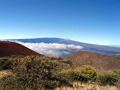 Mauna Loa above the clouds from the Mauna Kea Trail at about 10,000 feet.
Updates
As of now the Mauna Loa Summit Cabin and Observatory are closed due to the 2022 eruption. The Mauna Loa Trail is closed above Red Hill.
See the below for updates:
Mauna Loa Updates
"Largest" Mountain in the World
By far and away, Mauna Loa is the largest mountain in the world. From the ground, it only appears to be a small hill because the slopes of the peak are so gentle. Mauna Loa is known as a shield volcano because such volcanoes are similar to a shield lying on the ground, and always have very gentle slopes. An Oregon State Study (the link is now gone) claims that Mauna Loa is composed of 68,750 to 79,343 cubic kilometers of material, or 16,494 to 19,035 cubic miles of material, of which only a small part is above the ocean. So, how big is Mauna Loa? It is approximately 375 times the size of Mount Hood, and has quite a bit more rock than either the entire Cascade or Sierra Nevada mountain ranges, or to fill the Grand Canyon 18 times! In addition to the 5000 meters/16,000 feet of the mountain that is under the ocean, it is also known that Mauna Loa depresses the sea floor 8000 meters/26,000 feet. This makes the volcano's summit about 17000 meters/56,000 feet above its base by some measurements, although that is a somewhat dubious definition of a mountain base. In any case, Mauna Loa rises at least 33,000 feet above the sea floor, making it the first or second highest mountain in the world above its base. Its sister peak, Mauna Kea is the other contender and which peak is actually higher above its base is often contended.
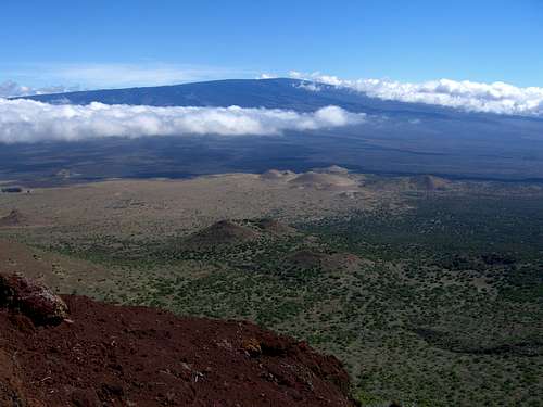 The huge mass of Mauna Loa as viewed from the slopes of Mauna Kea.
Routes Overview
Mauna Loa Trail The Mauna Loa Trail is the longest, but interestingly, for years was the most popular trail on the mountain (it seems in the last decade a lot of the traffic has switched to the Observatory Trail). The trail is long, but not overly steep or difficult. It can be hot since there is no shade available for much of the route, and it is almost always cold on top. There are two cabins to stay in along the way. The total round trip distance is 43.2 miles assuming you visit both the summit cabin and the true summit, and usually takes 3-4 days. Four is recommended. If you are staying overnight on Mauna Loa (which almost everyone would have to), you are required to register at the Kilauea Visitor Center, where you will receive the latest information about the cabins, water, weather number of people on the trail, etc. Observatory Trail The Observatory Trail is steeper than the Mauna Loa Trail. It is also much shorter and only 12.4 miles round trip. The route can be completed in a day, but many will want to camp at the Summit Cabin which is definitely recommended. The trail will climb to a junction after 3.8 miles. From the junction, the true summit is reached by following the trail 2.5 miles to the right, or the Summit Cabin is reached by heading 2.1 miles to the left. Ainapo Trail In addition to the above, there is the historic Ainapo Trail which was built by ancient Hawaiians. The Ainapo Trail is 20.4 miles round trip to the Mauna Loa Summit Cabin and usually takes three days. With 7600 feet elevation gain, this is the steepest and most difficult of the three trails to the summit of the mountain.
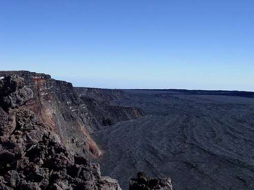 A view from of the crater from Mauna Loa's summit.
Getting There
Mauna Loa is on the island of Hawai'i (Big Island). There are two airports on the Big Island, located at Hilo and Kona. Hawai'i Volcanoes National Park is 30 miles from Hilo airport and about 96 miles from Kona airport. Mauna Loa Trail To get to the trailhead, located the signed road off Highway 11 not far west of the Hawaii Volcanoes National Park visitor center. Drive for 11.5 miles and park. In February 1995, we waited about an hour for a ride up to the trailhead. Hitching is possible, but can be slow. Observatory Trail From downtown Hilo, drive up the Saddle Road (Highway 200) about 29 miles to Pu`u Huluhulu and turn left (south). Continue 18 miles to the Mauna Loa Weather Observatory. There is a parking lot for hikers using the trail. There isn’t much traffic on this road, so hitching can be difficult, and most rental cars aren’t allowed on the road.
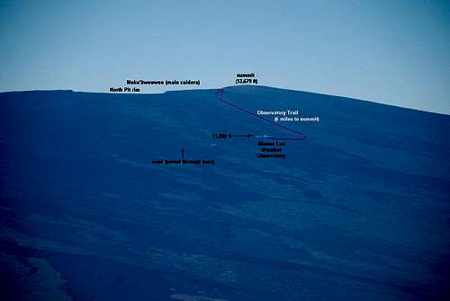 The Observatory Trail diagram.
Ainapo Trail The Ainapo Road begins at the cattle guard located on the Mauka side of Highway 11 in Ka`u, near the 40.5 mile mark. It is open during daylight hours only. You may park at either end on unvegetated sides of road and at the trailhead.
Historic Ascents of Mauna Loa
The summit of Mauna Loa was visited by prehistoric Hawaiians for ceremonial purposes. They constructed the Ainapo Trail from their closest village, Kapapala to the rim of Moku'aweoweo caldera. The Ainapo Trail had a series of shelters that were stocked with drinking water and fire wood. The Hawaiian method of ascent involved moving upslope in easy segments to lessen fatigue and to allow proper acclimatization. Footwear for the climb usually involved wrapping the feet with tea leaves or merely going barefoot. The major stages were a series of overnight camps, complete with small, warm, thatched houses and supplied with food water and firewood. Smaller stages were areas used as frequent rest stops in natural rockshelters, caves and lava tubes. Ascents of Mauna Loa by prehistoric Hawaiians were made during summit eruptions, when the godess Pele was present to honor her with chants, prayers and offerings. The first non-Hawaiian credited with climbing Mauna Loa is Archibald Menzies. Menzies was the surgeon/naturalist for the 1791-1795 Voyage of Discovery led by Captain George Vancouver of the British Navy. An expedition set out on Feb. 6 1794 from Kealakekua Bay with Chief Luhea in a large double hulled canoe that belonged to King Kamehameha. Menzies reached the summit of Mauna Loa on Feb. 16, 1794 where he used barometric readings to calculate the summit elevation at 13,564 ft. An excerpt from Menzies journal: "We managed to boil the chocolate in a tin pot over a small fire made of our walking sticks, and each had his share of it warm, with a small quantity of rum in it, before we went to bed. ...as it was agreed we should all sleep together to keep ourselves warm, we joined together everything we had for our general covering, made pillows of hard lava, and in this [way] was passed the night... Febuary 16. Next morning, at sun-rise, the Thermometer was at 26 degrees and the air was exceedingly keen and piercing... About 11 in the forenoon we arrived at the mouth of an immense crater... [we] crossed over this rugged hollow after a hard struggle, and by noon got to the highest part of the mountain, on the western brink of the great crater, where I observed the Barometer..."
Red Tape
A free backcountry permit is required and must be obtained by each party intending to overnight in the backcountry (including staying at the cabins) of Hawai'i Volcanoes National Park. They are issued on a first-come basis and can be collected at the Kilauea Visitor Center no earlier than the day before your climb. Their phone number is 808-985-6000. Office hours are 7:45 a.m. to 4:45 p.m. daily. For those climbing the Ainapo Trail (see Routes Overview), permission must be obtained from the State of Hawaii Division of Forestry and Wildlife to stay at the Halewai Shelter. Their phone number is 808-974-4221. Office hours are 8:00 a.m. - 4:00 p.m. Monday through Friday. Hikers continuing to the summit need to register with the National Park Rangers (808 985-6000). Day use of Ainapo trail does not require a permit, however, hikers are required to contact Kapapala Ranch at 808-928-8403 to obtain the combination for the locked gate. Be aware that the Mauna Loa Strip Road is sometimes closed for day use during the fire season. When the road is closed, the combination to the locked gate will be provided to those parties using the Mauna Loa backcountry overnight.
When To Climb
Mauna Loa can be climbed at anytime of the year. Spring and fall are often said to be the most comfortable times to make an ascent, but snow in winter and spring can actually be an added attraction. The tropical nature of the Hawaiian Islands lends little caution to the hazards involved in climbing Mauna Loa. Be prepared for winter conditions all year round. Yes, it really does snow in Hawai'i. It can snow at anytime of the year, with the months of December through March seeing the most accumulation and emperatures at night usually fall below freezing. There is little shade available on the mountain and sunlight is intense at the higher elevations so sunglasses and sunscreen are essential. It has been reported that snow has piled up as deep as 6-9 feet in the summit area, but this is very rare. In contrast to some other mountain areas, the higher you go, the drier the weather becomes, and on average, the summit area is much drier (but colder) than the slopes below.
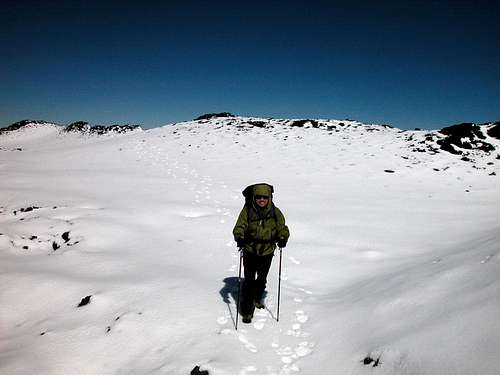 Snow does fall on Mauna Loa during certain parts of the year.
Camping
There are two free campgrounds in Hawaii Volcanoes National Park. Namakani Paio is right on the Hawai'i Belt Road (Highway 11) and is about a half a mile from the begining of the Mauna Loa Strip Road. There are also cabins at Namakani Paio operated by Volcano House lodge. Volcano House lodge is across from the Visitor Center right on the rim of Kilauea Crater. The village of Volcano also has several lodges, B & Bs, and a general store to stock up on provisions. On the mountain itself, there are very few campsites available due to the rocky nature of the peak. Nearly everyone stays in the cabins instead of camping. There are three huts available for public use on Mauna Loa. Pu'u Ula'ula (Red Hill) at 10,035 feet on the Mauna Loa Trail. Mauna Loa Summit cabin is at 13,250 feet on the Cabin Trail at the edge of Moku'aweoweo Caldera, directly across from the actual summit. Halewai shelter is at 7,750 feet and is located in the Kapapala Forest Reserve, three miles from the trailhead of the Ainapo Trail.
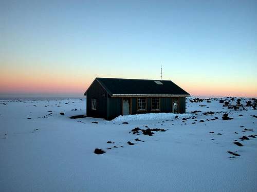 Mauna Loa Summit Cabin
Mountain Conditions
Current trail conditions can be obtained by calling the Kilauea Visitor Center at 808-985-6000. The Mauna Loa Observatory is a National Oceanic and Atmospheric Administration (NOAA) weather/solar observatory on the north slope of Mauna Loa with live web-cams and up to the hour weather reports from several sources. Weather and climate data for the Mauna Loa Slope Observatory is below. *National Weather Service Data 1955-2006. This weather station is at 11,140 and at the Observatory Trailhead. Expect it to be about 10 degrees colder at the summit of Mauna Loa or at the Summit Cabin.
| MONTH | AVE HIGH | AVE LOW | REC HIGH | REC LOW | AVE PRECIP (in) |
| JAN | 50 | 33 | 67 | 19 | 2.48 |
| FEB | 50 | 33 | 64 | 18 | 1.51 |
| MAR | 50 | 33 | 65 | 20 | 1.75 |
| APR | 52 | 35 | 67 | 24 | 1.33 |
| MAY | 54 | 37 | 68 | 27 | 1.00 |
| JUN | 57 | 39 | 71 | 28 | 0.51 |
| JUL | 56 | 39 | 70 | 26 | 1.16 |
| AUG | 56 | 39 | 68 | 28 | 1.50 |
| SEP | 56 | 38 | 67 | 29 | 1.36<TD |
| OCT | 55 | 38 | 66 | 27 | 1.16 |
| NOV | 53 | 36 | 65 | 25 | 1.78 |
| DEC | 51 | 34 | 67 | 22 | 2.01 |
External Links
Hawaii Volcanoes National Park Homepage Mauna Loa Weather Observatory The excellent Mauna Loa Trail Guide to trekking on Mauna Loa can be obtained online. It was written by a National Park Service volunteer by the name of Lisa Peterson and it is the definitive guide to the trails on Mauna Loa. It includes detailed mileage, notes on history and extensive information about the geology of Mauna Loa and eruption histories.