
-
 6915 Hits
-
 80.88% Score
-
 13 Votes
|
|
Canyon |
|---|---|
|
|
42.68400°N / 103.4888°W |
|
|
Hiking, Scrambling |
|
|
Overview
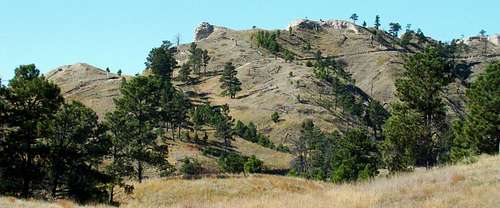
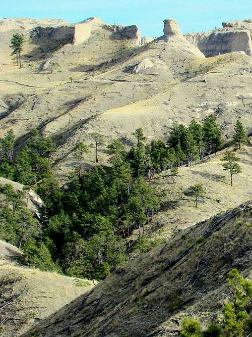 The Rugged Terrain of Mexican Canyon
There are many small canyons at Fort Robinson State Park in Nebraska. Most of those canyons are unnamed and accessible only by long hikes, usually off-trail. Mexican Canyon is possibly the most scenic of all the canyons at the state park, rivaling even the Smiley Canyon Loop Trail. The name Mexican Canyon does not show up on most maps – only state park maps. Several small branch canyons on the east side of Mexican Canyon provide explorers some exceptional opportunities. The sculpted canyon walls on the east side are magnificent representations of the rugged beauty of the whole system of buttes, ridges and canyons found at Fort Robinson. Mexican Canyon is about 2 miles long with a gain of 370 feet from the trailhead near the mouth to the trail junction high point.
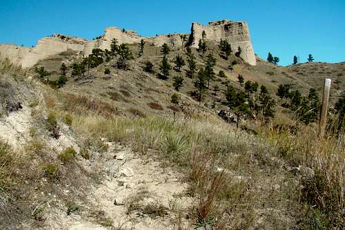 East Mexican Canyon Trail
While there is an abundance of wildlife at Fort Robinson, deer may be what are most commonly seen along the trail. However, the bighorn sheep herd at the fort seems to really like this canyon and are often seen here. Wild turkeys are also abundant in the area and eagles are sometimes seen soaring above the high cliffs and most remote locations in the canyon. The state park has a herd of longhorn cattle that are sometimes in the Mexican Canyon area. The longhorns have been seen sharing space with one of the pronghorn antelope herds at the state park. There are mountain lions in the area, but are normally pretty reclusive, thus rarely seen. There are pockets of trees in and around the canyon. But, the density of the forest there is not as great as it once was. Fort Robinson was devastated by large forest fires in 1989. By keeping much of the re-growth under control, that forest is coming back in a more controlled manner. There are a few locations along Mexican Creek where deciduous trees grow, providing a little autumn color every year. With all the rock formations, rugged buttes and deep ravines in the canyon, it would be easy to spend the better part of a day photographing the moods of the area, as well as the wildlife one encounters on a trip through the area.
Getting There
Fort Robinson is 3.4 miles west of Crawford, Nebraska on Highway 20. The trailhead is accessed from the Mexican Canyon Parking Lot, which is just north of Soldier Creek Road, about .7-mile past the historic officers’ homes.
Route Options
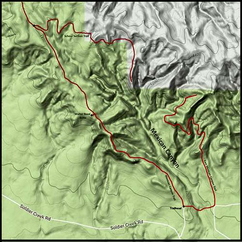 Mexican Canyon Trails Map
Mexican Canyon lies mostly in the Crawford USGS Quad, though extreme upper parts of the canyon are in the Smiley Canyon USGS Quad. Free maps for the trails at Fort Robinson are available at the office. The Nebraska National Forest - Oglala National Grassland map shows the area, but with no detail or labels. The state of Nebraska also has an interactive trails map available online. You can access that by clicking here: Nebraska Interactive Trails Map
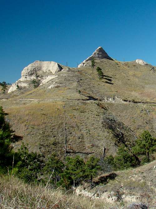 Pyramid Rock
The two main hiking routes for Mexican Canyon (both out-and-back) are the Mexican Canyon Trail and the East Mexican Canyon Trail. Both start at the Mexican Canyon Trailhead (shown on the map) and immediately go in different directions. The altitude at the trailhead is about 4,030 feet. Though there is not a trail that follows the floor of the canyon, the east trail does cross the floor at the mouth of the canyon. There is a spring there, but it is one of very few in the area. Anyone who would choose to try to bushwhack up the canyon over the floor will find it rough going. The east and west trails mostly follow old roads on the canyon sides. East Route: Heading east from the trailhead, the East Mexican Canyon Trail crosses the canyon floor and continues east for a short ways, then turns to meander in a mostly northerly direction. The trail varies from single track to two-track. There are trail markers in places, which is very helpful where the trail is faint. The distance from the trailhead to the end of the trail is about 1.5-miles, with a gain in altitude of about 270 feet. This trail takes hikers past towering sandstone cliffs and formations. The photo opportunities along this route are plentiful. West Route: The Mexican Canyon Trail is the west route and is used by those wishing to go further up the canyon, and also by those wishing to summit Walter Reed Butte. The trail is a two-track road often used by horseback riders, and infrequently by state park service Jeeps. The true high point on the Walter Reed Butte ridge is about 1.4 miles up the trail and is a short bushwhack up the side of the butte. From the trailhead to the junction with the School Section Trail is about 370 feet in altitude gain. Not only does the Mexican Canyon Trail end there, the Spring Creek Loop Trail also begins at that trail junction. The distance to the School Section trail is 2.1-miles one-way. Extra Option - School Section Trail: For any hiker wishing to explore the upper part of the east side of Mexican Canyon, the School Section Trail provides a .6-mile route (one-way) to trail’s end. It’s doubtful anyone bushwhacks over to the upper end of the East Mexican Canyon Trail, as that would be at least 2 miles of very rugged off-trail hiking and climbing. So, from the Mexican Canyon Trailhead to the end of the School Section Trail would be about 2.7 miles one-way.
Red Tape
 Mexican Canyon Trail on West Side
You will need a state park vehicle pass to get into Fort Robinson. There are camping fees, and they really do enforce campfire and fireworks regulations. The whole northwest part of Nebraska has lost over 200 square miles of forests and grasslands in the last few years. Everyone takes fire dangers seriously. That is why there are strict regulations on campfires and fireworks. There are some firearms restrictions that depend on local hunting seasons. Consumption of alcoholic beverages is also quite regulated, so be forewarned. Call the state park office at (308) 665-2900 for any other concerns.
When to Explore
 East Mexican Canyon Trail Scenic Route
 Mexican Canyon Sign on Canyon Floor
The canyon is open to explore any time of the year. But, deer hunting and wild turkey hunting seasons may not be the best times. Call the state park office for more specific information on when hunting seasons are happening at Fort Robinson. If you must hike during hunting season, wear lots of orange. There is no winter trail maintenance, so if there is much snow, you may need snowshoes. Summer lightning and hail are also things to be clearly concerned about. For the latest weather forecasts and conditions, click on the link below:
Fort Robinson – Crawford Area Weather Forecast & Conditions
Camping & Lodging Options
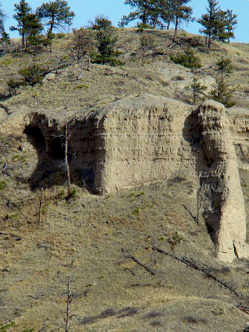 Mexican Canyon Cave
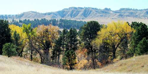 Trail View of Cheyenne Buttes
Fort Robinson offers tent and RV camping, as well as lodging in the old barracks and the historic officer’s quarters. You can find out the state park’s latest information, including how to make reservations, by clicking on their website:
If you prefer, you may call the state park office at: (308) 665-2900 There is also some camping and lodging at nearby Crawford. You can access their city website at: