
-
 4241 Hits
-
 80.49% Score
-
 12 Votes
|
|
Mountain/Rock |
|---|---|
|
|
42.39079°N / 13.68867°E |
|
|
Download GPX » View Route on Map |
|
|
Hiking, Scrambling |
|
|
Spring, Summer, Fall |
|
|
6322 ft / 1927 m |
|
|
Overview
 Monte Bolza seen across Campo Imperatore (by RenatoG) Monte Bolza seen across Campo Imperatore (by RenatoG) |
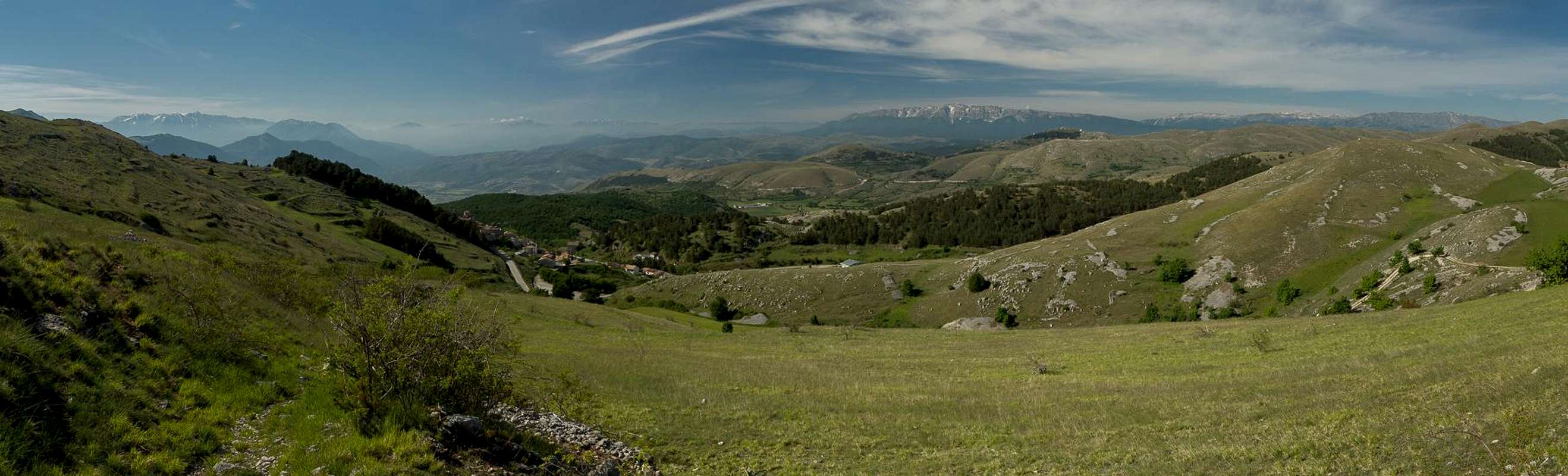
At less than 2000m Monte Bolza is rather one of the more insignificant mountains of the Gran Sasso Range. It is a grass covered mountain with several limestone summits located at both ends of a west-east running summit ridge of almost 2km length. Its highpoint, Cima di Monte Bolza (1927m) can be found at the western end while the eastern summit (sometimes also called Monte Bolza (1904m)) is located at the eastern end together with half a dozen satellite summits of comparable height. The mountain stands solitary to the south of Campo Imperatore, the huge central Italian high plateau at the base of Gran Sasso's highest mountains.
 |  |  |
Thanks to this location Monte Bolza is a famed lookout summit offering a wonderful close-up view of Gran Sasso across the plateau. It starts at Corno Grande in the west and ends at Monte Camicia with a number of minor summits following even further east. On clear days you can see the Majella Range (the Apenino's second highest one) in the south-east as well as Monte Sirente and Monte Velino in the south-west. Thus, a traverse of the Monte Bolza summit ridge belongs to one of the most memorable undertakings in the area.
 |  |  |
Monte Bolza is listed as a hiking summit and for most parts of the traverse this is true. However, the ascent from the saddle Guado della Montagna to the east summit is very steep and unmarked. Basically you scramble up the east face across limestone boulders covered by all kinds of ground-hugging plants. The face gets serious in wet conditions, even more so upon descending.
 |  |  |
The traverse of the summit ridge, in particular the eastern part is an exposed scramble across limestone blocks. Exposure never gets serious but in some parts both north and south face drop away steeply leaving a knife-edge ridge. There is one section, which usually is circumvented by descending to the north side and passing a big tower. After the first 500m the ridge gets broader and the character of the traverse turns into an easy hike. Only the descent to Sella di San Cristoforo from Cima di Monte Bolza requires a bit more than average attention.
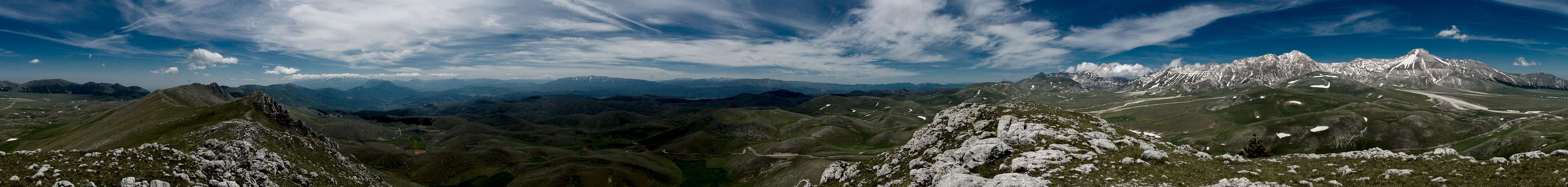
360° Summit Panorama
  |
Getting There
 |
Monte Bolza is located to the south of Gran Sasso d'Italia right across the plain of Campo Imperatore, It can be reached from Rome or Pescara (the closest airports) via motorways A24 and A25. The last stretch to the trailhead at Castel del Monte runs across narrow mountain roads.
- From Rome:
- Southern access:
- Take motorway E80 / A24 from Rome to Torano.
- Switch to motorway A25, direction Pescara.
- At the exit Popoli / Bussi switch to SS163 north.
- Pass Bussi and Capestrano.
- Right after Capestrano turn onto SS602 through Ofena.
- After the village turn onto SS17bis, which will take you to Castel del Monte.
- Take motorway E80 / A24 from Rome to Torano.
- Northern access:
- Again, take motorway E80 / A24 from Rome to Torano.
- Stay on A24 until you reach the exit Assergi.
- Switch to SS17bis east, which will take you across Campo Imperatore and straight to Castel del Monte.
- Again, take motorway E80 / A24 from Rome to Torano.
- Southern access:
- From Pescara
- Take motorway E80 / A25 westward in direction Rome.
- At the exit Popoli / Bussi switch to SS163 north.
- Pass Bussi and Capestrano.
- Right after Capestrano turn onto SS602 through Ofena.
- After the village turn onto SS17bis, which will take you to Castel del Monte.
- Take motorway E80 / A25 westward in direction Rome.
Route
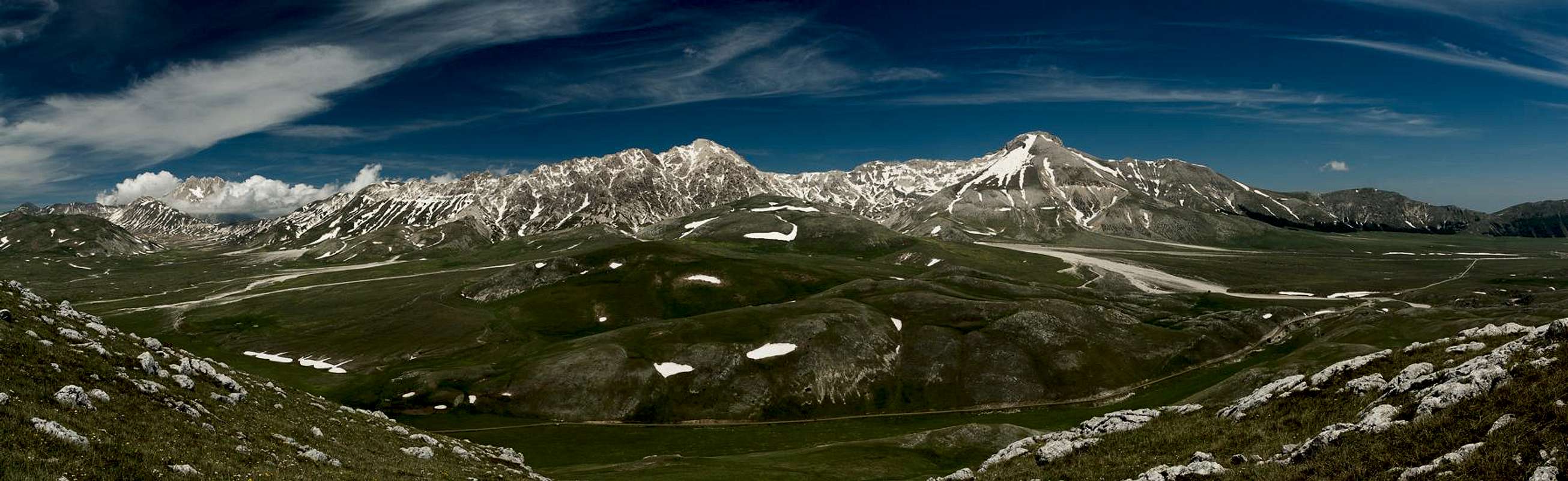
 The Monte Bolza summit ridge seen from the east summit
The traverse of the whole ridge of Monte Bolza is a wonderful day tour with exceptional views across Campo Imperatore towards the main summits of Gran Sasso 'Italia. It is listed as a hiking route but requires more than just walking practice. The ascent to the eastern summit is really steep and the meandering path across the rocky eastern part of the summit ridge is moderately exposed. There is no protection and you are on your own.
Access to the saddles to each side of Monte Bolza is easy. To the west there is a dirt road, to the west a well marked hiking path. There are no marks for the route to the eastern summit so you have to use your own judgement. We found the scramble to the southern foresummit (separated by a saddle from the eastern summit) practicable. We crossed the saddle and found minimal signs (withered arrows on the rocks) to guide us to the top.
The traverse follows the ridge except for a tower right in the middle of the rocky section, which you can pass on its northern side. Return to the ridge which gets less and less rocky and turns into a sequence of grassy hills. The western summit, Cima di Monte Bolza, is rocky again but requires no skills. Descend along a path directly across the west slopes of the Cima.
Red Tape
 Common European viper (also common adder, Vipera berus)
Monte Bolza is part of the Parco Nazionale del Gran Sasso e Monti della Laga and the usual restrictions apply. More information on the park can be found here
Accommodation
 |
The following links offer accomodation in the vicinity of Campo Imperatore. The third link lists hotels and apartments for the whole Gran Sasso area.
Weather Conditions
 Rainbow halo around the sun
Maps & Books
Maps
- Digital Maps
- Regular Maps
- Gran Sasso d'Italia. Carta dei sentieri
Technopress
1:15.000
ISBN: 978-8889429877
- Parco Nazionale del Gran Sasso,
Kompass WK2476
1:50000
ISBN: 978-3850268486
- Gran Sasso. Atlante dei sentieri
Ricerche
1:25000
ISBN: 978-8886610391
- Gran Sasso d'Italia. Carta escursionistica
Il Lupo
1:25000
ISBN: 978-8888450438
- Gran Sasso d'Italia. Carta dei sentieri
Books
- Gran Sasso 1
Emanuele Lucchetti, Federica Fais
Technopress
ISBN: 978-8889429198
- Gran Sasso 2
Emanuele Lucchetti, Federica Fais
Technopress
ISBN: 978-8889429389
- Gran Sasso d'Italia
L. Grazzini, P. Abbate
CAI
ISBN: 978-8836505180
- Sentieri nel parco nazionale Gran Sasso-Laga
Stefano Ardito
Iter Edizioni
ISBN: 978-8881772049
- Abruzzen
Heinrich Bauregger
Rother Verlag
ISBN 978-3-7633-0413-2