
-
 5647 Hits
-
 90.81% Score
-
 33 Votes
|
|
Mountain/Rock |
|---|---|
|
|
46.60322°N / 12.29713°E |
|
|
Hiking, Via Ferrata |
|
|
Summer, Fall |
|
|
7697 ft / 2346 m |
|
|
Overview
 Coming out of the tunnel with Monte de le Cianpedele's summit Coming out of the tunnel with Monte de le Cianpedele's summit |
Without its neighbours Monte de le Cianpedele could be an impressive mountain. Located between Valon de Lavaredo in the north and Val de le Cianpedele in the south its summit rises about 1000m above the confluence of the two valleys. The east face is a typical Dolomite face, though maybe a bit more brittle than is usual. On the other hand its mother range doesn't show more solidity. On the western side, however, easy slopes gradually head down to Lago di Misurina through the wide Val Longeres, from where you barely can distinguish our summit among its neighbours.
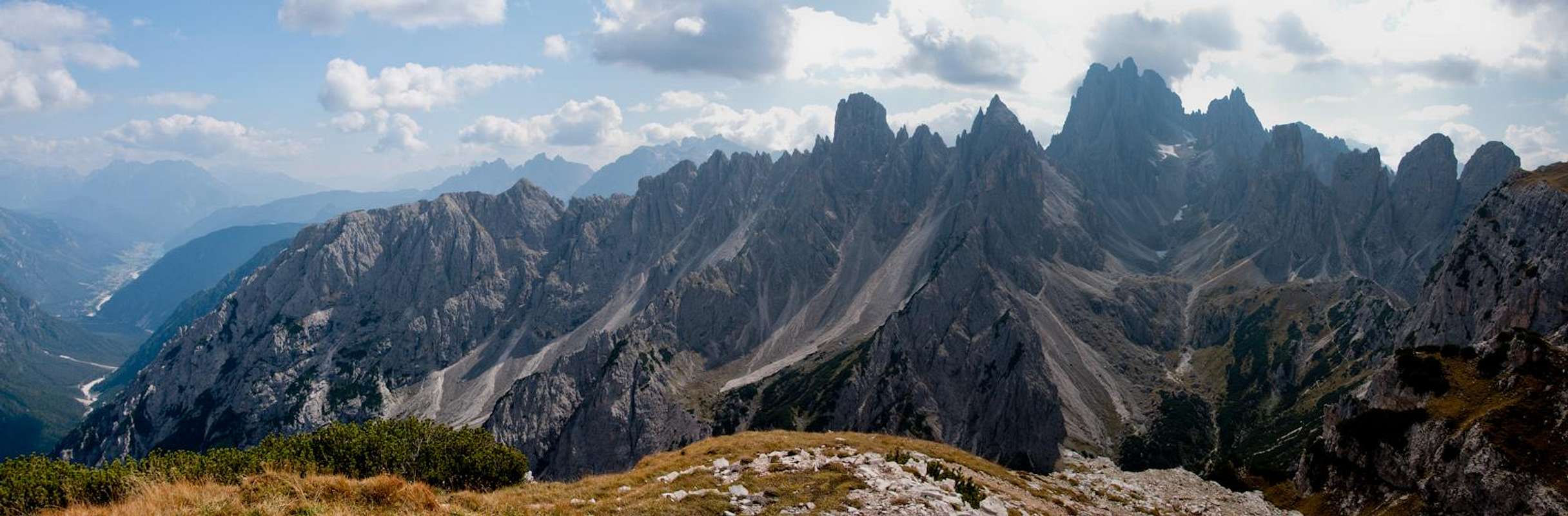
What neighbours are they? To the south, the mother range of Monte de le Cianpedele rises with an uncounted number of towers and spires: the Cadini di Misurina. To the north, only slightly more than one kilometre away, tower the south faces of Drei Zinnen / Tre Cime di Lavaredo. And all around on the mid-range horizon there are the Sexten / Sesto-, Cortina- and Prags / Braies Dolomites. And thus our mountain vanishes from sight.
 |  |  |  |
Still, many hikers visit its summit and not because of the exceptional views you have there. Monte de le Cianpedele is the northern end of Sentiero Bonacossa the famous Via Ferrata (rather Sentiero Attrezato) through the Cadini. Since most hikers climb the ferrata south to north, our mountain usually is the final climax after so many that come before. Senntiero Bonacossa climbs a 50m step in the east face of Cima Cadin de le Bisse from where it follows a beautiful ledge through and across Monte de le Ciandedele.
Yes, in one point close to the summit the path runs right through the mountain. Back in WW I, when the nearby Drei Zinnen / Tre Cime where the border between Austria and Italy, the whole mountain and its direct neighbours where fortified by the Italian Alpini. Between Forcella de Rinbianco and Forcella Longeres the natural protection was used to establish support routes which followed ledges and bands across the mountains. Today these routes are used for the ferrata and everywhere you can witness the old positions. Monte de le Cianpedele was the northernmost outpost south of the border and here a tunnel of 100m length protected one of the otherwise unprotectable sections.
 |  |  |
Views from the mountain are exceptional, thanks to its impressive neighbours. Also, there are quite a number of gullies which drop through the east face down into Val de le Cianpedele. They offer wonderful saddle views to the Cadini di Misurina. Monte de le Cianpedele has several summits, the highest of which can be found in its easternmost part. From there Rifugio Auronzo can be reached in a mere stroll. Both the rifugio and the summit are located at roughly the same elevation and Forcella Longeres is a barely pronounced saddle only 100m lower.
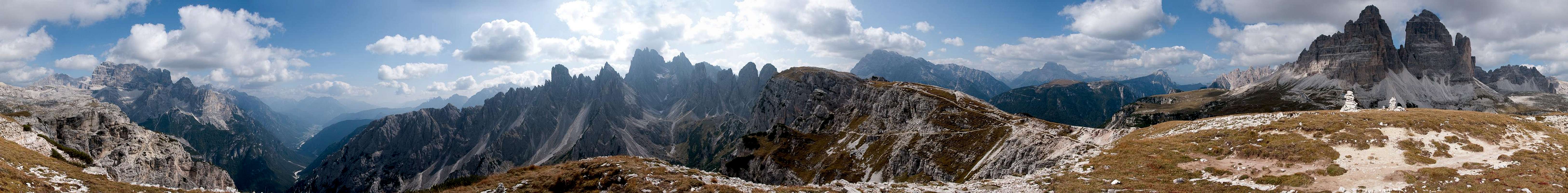
360° Summit Panorama
  |
Getting There
 |
The closest trailhead for Monte de le Cianpedele is Rifugio Auronzo beneath the south faces of Drei Zinnen / Tre Cime. To reach the summit from there you basically have to stroll across a plateau. Misurina or Auronzo can serve as trailheads as well.
From Veneto
- Take motorway A27 from Venezia (Venice) to Ponte nelle Alpi
- Take SS51 (Alemagna) to Cortina d'Ampezzo
- Take SR48 across Passo Tre Croci
- Turn left on SP49 to Misurina Lake
- Take the toll road to Rif. Auronzo from the northern end of the lake
From Südtirol / Alto Adige
- Take Brenner motorway A22 to Bressanone (Brixen)
- Take SS49 through Val Pusteria (Pustertal) until you reach Dobbiaco (Toblach)
- Turn south onto SS51 to Cortina d'Ampezzo.
- At Carbonin (Schluderbach) turn left onto SS48bis to Misurina and on to Rif. Auronzo.
From Trentino
- Take Brenner motorway A22 to Trento
- Take SS621 or SP71 into Val di Fassa
- Take SS48 across Passo Pordoi to Arabba
- Stay on SS48 and drive across Passo Falzarego to Cortina
- Take SR48 across Passo Tre Croci
- Turn left on SP49 to Misurina Lake and on to Rif. Auronzo
Red Tape
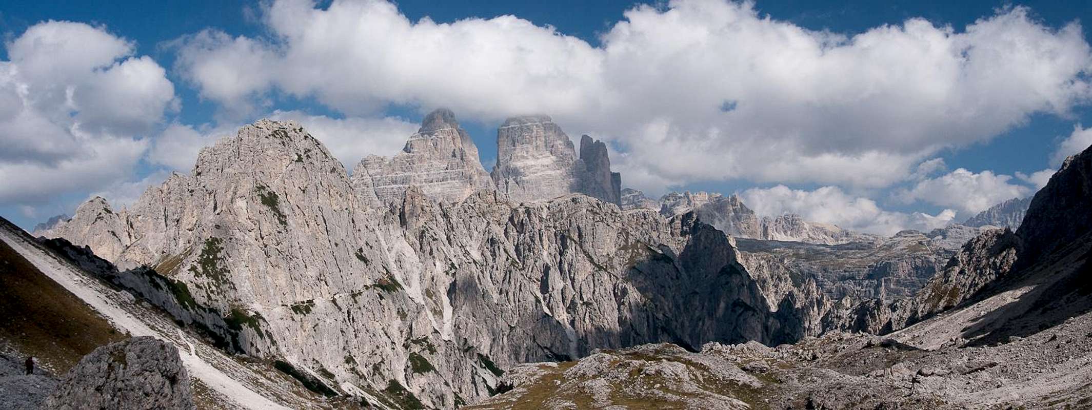
 Saddle View Cadini di Misurina
There's no red tape here. As the trails date back to WW I treat everything you find (tunnels positions) with the respect it deserves.
Accommodation
 |
The closest Refuges are
- Rifugio Auronzo
- Rifugio Lavaredo
- Rifugio Fonda Savio
Down in the Valleys Misurina and Auronzo offer the closest hotels and apartments.
Weather Conditions
Maps & Books
Maps
Digital Maps
Regular Maps
- Sextener Dolomiten / Dolomiti di Sesto
Tabacco Map 010
1:25000
ISBN: 978-8883150104
- Cortina d'Ampezzo e Dolomiti Ampezzane
Tabacco Map 003
1:25000
ISBN: 978-8883150036
- Sextener Dolomiten / Dolomiti di Sesto
Kompass Map WK58
1:50000
ISBN: 3-87051-065-X
- Sextener Dolomiten / Dolomiti di Sesto
Kompass Map WK625
1:25000
ISBN: 3-85491-749-X
Books
Monte de le Cianpedele features everywhere you find a description of Sentiero Bonacossa.
- Dolomiten 5 / Sexten - Toblach - Prags
Franz Hauleitner
Rother Verlag
ISBN: 3-7633-4199-4
- Klettersteige Dolomiten
Werner Höfler
Rother Verlag
ISBN: 3-7633-3096-8
- Hüslers Klettersteigführer Dolomiten
Eugen E. Hüsler
Bruckmann Verlag
ISBN: 3-7654-4161-9