
|
|
Route |
|---|---|
|
|
45.92059°N / 10.96383°E |
|
|
Mountaineering, Skiing |
|
|
Winter |
|
|
Half a day |
|
|
Alpine F |
|
|
Overview
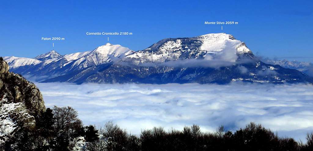
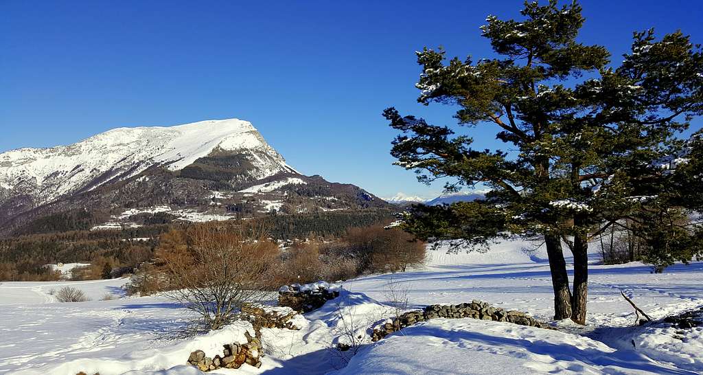
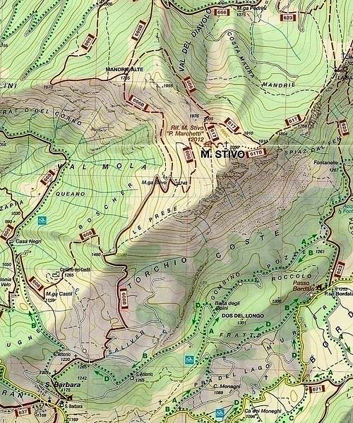
Monte Stivo 2054 m is a fine mountain located in the Trentino Pre-Alps, Bondone-Stivo chain. It is situated to the North-East of Lago di Garda in a dominant position above the town of Arco di Trento in Southern Trentino and between the Valle del Sarca to the West and the Vallagarina to the East. Monte Stivo is connected to the North to Monte Bondone by a long ridge, while to the South is facing Monte Altissimo di Nago, the Northern slopes of Monte Baldo and Lago di Garda.
Offering a superb 360° panorama, the summit of the Stivo is accessible from several sides (Passo Bordala, Santa Barbara, Malga Campo). It's a fine and rather easy destination, therefore quite popular, also in wintertime, on skis or by foot. In fact, even after fresh snowfalls there is almost always a good trace that rises from the side of S. Antonio.The proposed route is the most classic and frequented. It starts from the locality of Sant'Antonio above Passo Santa Barbara 1169 m, reachable from Bolognano di Arco or from the Val di Gresta (Ronzo-Chienis) and is the easiest way to reach the summit.
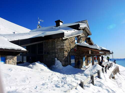
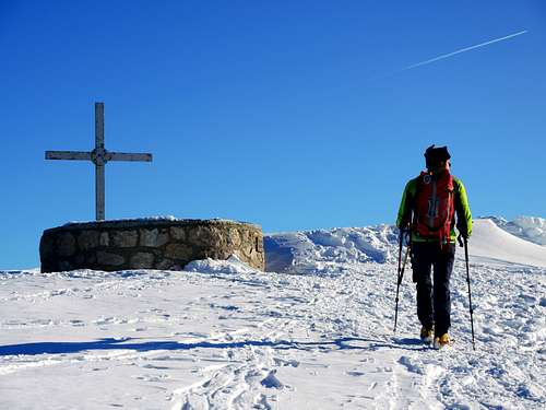
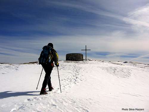
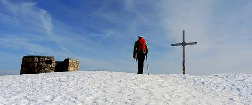
It is only necessary to have a certain resistance to overcome a difference in level of just over 800 meters. On the summit there is an iron cross and a circular stone construction equipped with a metal wheel bearing the names of all the peaks visible in every direction. About forty meters below the summit on the West side is situated the fine Refuge Prospero Marchetti 2012 m.
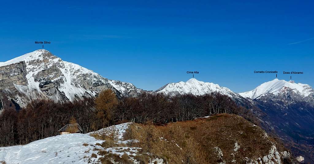
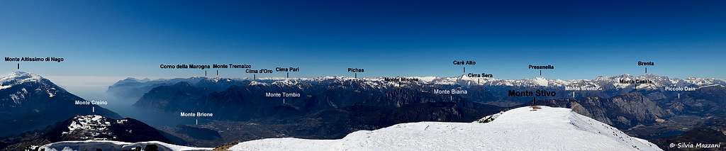
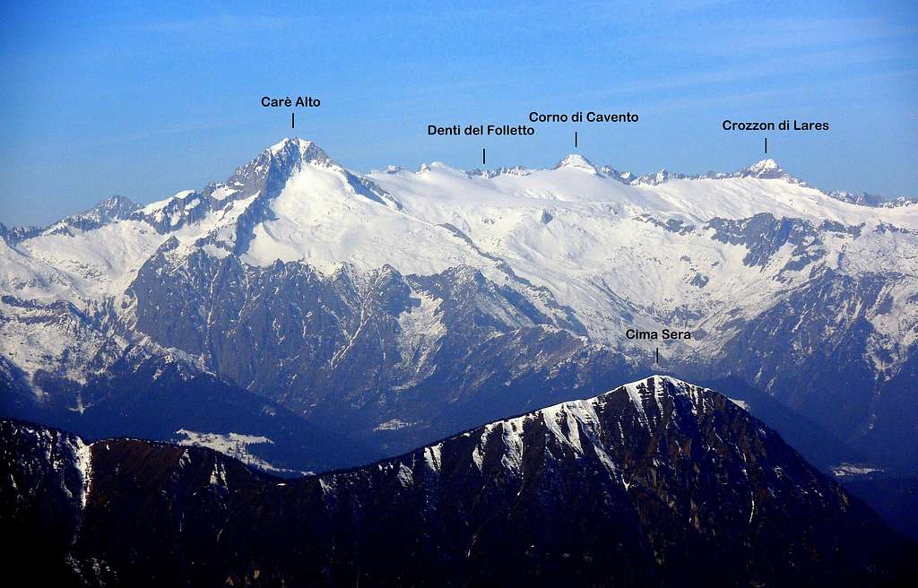
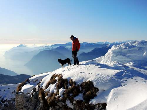
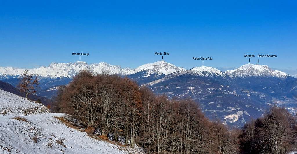
With its geographical position and the altitude of 2059 meters, Monte Stivo is an exceptional panoramic point overlooking Lake Garda, the Sarca Valley and Vallagarina. From the top the view sweeps over the Pasubio, the Piccole Dolomiti and the Lagorai to the East, the Monte Altissimo and Monte Baldo group to the South, the wild Alpi di Ledro to the SW, the Sarca Valley walls and the Adamello and Presanella groups to the NW, the Brenta Dolomites to the North.
Getting There
The starting point of this route is the locality of Sant'Antonio above Passo Santa Barbara.
Access: from the A22 Brennero autoroute exit Rovereto Sud and take the SS 240 in the direction of Riva del Garda, reaching Loppio after 6.5 km. At the roundabout leave the state road and turn to right onto the SP 88 Val di Gresta for 10 km. Pass the villages of Valle San Felice and Pannone and before entering the village of Ronzo-Chienis turn to the left on the road SP 48 that leads to Passo Santa Barbara 1169 m, reaching it after another 3 km. As well as from Ronzo-Chienis in Val di Gresta, the Passo di S. Barbara can also be reached from the opposite side, coming from Bolognano di Arco, along the narrow and amazing road of Monte Velo.
It is possible to park the car at Passo Santa Barbara or reach by car the locality Sant'Antonio above the Passo Santa Barbara and shortly after passing the Baita Castil 1224 m leave the car in a parking lot at an altitude of 1226 m. Let's leave the dirt road to the right of the parking lot and continue past the parking lot, starting to walk up the road.
Route Description
Monte Stivo winter ring from Sant'Antonio
Difficulty: F (Alpine scale) or EEI
Difference in level: 800 m from Sant'Antonio
A fine and worthwhile itinerary, leading on a superb summit
From the parking lot, leave the dirt road to the right and continue past the parking lot starting to walk up the road. As soon as we pass a small house we find a crossroads, we proceed to the left and reach a second fork where we continue straight. A few tens of meters later at a third junction the road continues to the right, we turn to left on the mule track CAI 608/bis to reach the locality Le Prese 1480 m (junction, signposts and majesty of wood, junction with the path CAI 608). The left path goes down to Monte Velo and Bolognano, the itinerary to the top of Monte Stivo instead turns to the right towards wide meadows.

|

|

|

|
Ignore the path on the left and start to climb steeply the hill in front of. After a few tens of meters above Le Prese there are two possibilities to reach the summit:
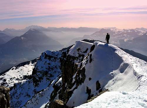
A - proceeding directly in the NE direction you will start to climb steeply the broad ridge leading directly to the summit of Monte Stivo. Continue to walk up along the wide ridge getting after a traverse ascent the Rifugio Marchetti 2012 m. To reach the summit located just above the refuge, turn sharply to the right (East) traverse toward the summit ridge and following it climb up to the summit cross and the stone observatory.
B - Proceeding instead on the left halfway on a traverse with North direction you will arrive under some alms located in the middle of the wide West slope of the mountain. Climb up in the middle of the slope reaching a first alm and a second group of alms higher up (Malga Stivo 1768 m). Continue to climb a little obliquely to the right, rejoining the previous itinerary in the vicinity of the traverse towards the refuge.
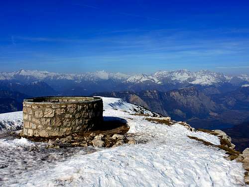
At the junction turn to the left and traverse the slope reaching the Refuge Prospero Marchetti. From the hut a last short ascent to the right leads to the summit. The view is wonderful at 360° on the various mountains and groups that surround the summit in every direction: nearby the Bondone, Piccole Dolomiti to the East, Lagorai to the NE, Monte Altissimo di Nago and Monte Baldo to the South, the Prealpi Gardesane with the Garda Lake to the SW, the Alpi di Ledro and further the groups Adamello and Presanella to the West, the Brenta Dolomites to the NW and the Valle del Sarca with its stone giants Monte Casale and Monte Brento above. For this reason on the top, next to the cross, there is an interesting stone panoramic observatory equipped with metal directional arrows inside, indicating the name and the altitude of the surrounding mountains, indicating the name and the altitude of the surrounding mountains, by means of which it is possible to identify all the most important peaks at 360 degrees with an easy and very interesting recognition.
Descent: you can indifferently follow the path you have not practiced uphill, making a ring, or return on the same route chosen for the ascent. From the summit you return to the Rifugio Marchetti and descend steeply in the broad basin below the hut, heading in the SW direction to the well visible Malga Stivo. After reaching the Malga Stivo at 1768 m, continue the descent passing the hut and aiming for the service cableway to the Marchetti refuge, then to the old building under the same. Just below the itinerary turns to the left, following a half-hill trail that leads back to Le Prese, where the ring walk is closed. Reversing the route done on the walk up we return to the parking lot. Following instead the broad ridge in the left direction you will return back to Le Prese.
Essential Gear
Warm clothing and equipment for the progression on snowy ground, an ice axe and crampons may be required in case of frozen ground.
Red Tape
No fees no permits required
When to climb
The itinerary is practicable all year round, while the winter conditions are variable depending on the snowfalls, they generally occur from mid-December to the end of March. Due to the altitude of the mountain, overcoming the 2000 meters, Winter and early Spring ascents requires the adequate clothing, crampons and an ice-axe may be useful and well as the ski-mountaineering gear in case of deep snow.
Hut
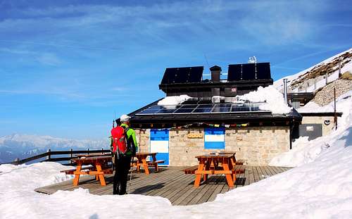
Rifugio Prospero Marchetti allo Stivo, 2012 m
Owner: S.A.T. Arco
Guardian: Alberto Bighellini
Size: 23 persons + 4 in the winter shelter
Open: from June to September and Christmas holidays. In the remaining periods it's open during the weekends
The refuge is dedicated to the founder and first president of the SAT (Società degli Alpinisti Tridentini), was inaugurated in 1906 and then repeatedly extended and renovated.
Accomodation
Several possibilities of accomodation in Arco, Val di Gresta and surroundings.
Meteo
Guidebooks and maps
Kompass 687 - 1.25.000
LagirAlpina sheet 15 - Valle del Sarca - 1:25.000