-
 9165 Hits
-
 82.48% Score
-
 15 Votes
|
|
Mountain/Rock |
|---|---|
|
|
49.75600°N / 117.22°W |
|
|
Hiking, Scrambling, Skiing |
|
|
Spring, Summer, Fall, Winter |
|
|
8035 ft / 2449 m |
|
|
Overview
For those wanting to do a straightforward summit in Kokanee Glacier Provincial Park, Mount Giegerich may be the mountain to begin with. It is located in the southwest portion of the park. Established in 1922, Kokanee Glacier Provincial Park is one of the oldest parks in British Columbia’s provincial park system. Mount Giegerich lies at the south end of a 5 km long ridge that connects itself to Nansen Mountain, Mount Robert Smith, and Boomerang Mountain. The mountains of the park are part of the Kokanee Range, a subrange of the Selkirk Mountains.
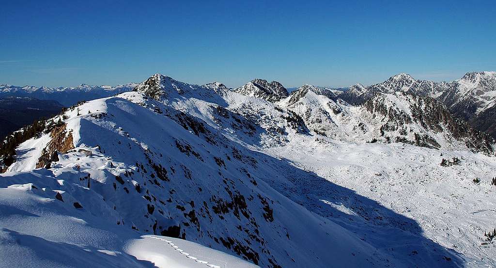
The views from the top are great and from the vantage point of the summit, you are able to see the Valhalla Range to the west, the Purcells to the north, and Glory Basin and the mountains surrounding it to the southeast. Once you are on Giegerich, Nansen Mountain is a relatively simple traverse to the NNW for those wishing to visit another peak for the day.
Besides being a great destination for hiking, scrambling, and mountaineering, the area is also a very popular destination for backcountry skiers. When talking about skiing in the park, Chic Scott describes it as "one of the best destinations for powder skiing in Western Canada" (Summits and Icefields - Columbia Mountains by Chic Scott, page 69).
Mount Giegerich is named after Henry Giegerich, a prominent merchant in the Ainsworth and Kaslo area during the early 1900’s.

Getting There
Most people doing the Mount Giegerich scramble would be those who are staying at the Kokanee Glacier Cabin or camping at Kaslo Lake. The scramble can be done in a day without staying in the park, but the combination of driving and hiking would make it a full day. This page will only describe the approach from the Gibson Lake trailhead. Lemon Creek and Enterprise Creek are other options for entering the park, however, both receive little in the way of trail maintenance. As of 2011, entering the park from Enterprise Creek is not recommended. The road is washed out around 7km from the trailhead and there is a significant amount of fallen trees on the trail obstructing the way. Please check on current road and trail conditions if you wish to enter this way. Lemon Creek is more manageable, however, it still requires driving up potentially poor road conditions and hiking up overgrown and unmaintained trail. There is some talk of doing some work to this trail in the near future.
To get to Gibson Lake from Nelson, cross the bridge and take Highway 3A along the north shore of the West Arm of Kootenay Lake for approximately 19 km. Once you are in Kokanee Creek Provincial Park, watch for a sign indicating the turnoff for Kokanee Glacier Provincial Park. It is a small sign and easy to miss. Take the turnoff and drive up Kokanee Glacier Road for about 16 km to the parking lot at Gibson Lake. This is a rough road and driving the 16 km can take 45 minutes or more. Low clearance vehicles do make it up the road regularly, but it isn’t always recommended.
If you are leaving your vehicle overnight at the trailhead, wrap it up with chicken wire to protect it from the porcupines of the area who will chew on tires, wiring, and rubber hoses. There is all the chicken wire needed at the parking lot. Secure the bottom with rocks and prop the top up with sticks. There will be plenty of vehicles to see and use as an example.
The hike to the campground takes you to the south end of Kaslo Lake or carry on to the north end of the lake to get to the Kokanee Glacier Cabin. It is 7.5 km to the cabin from Gibson Lake and involves an elevation gain of around 450m (1500 feet). It is a very well travelled and groomed trail to take when it is dry. When snow exists, traversing across the slope above Kokanee Lake can be very difficult and treacherous. The slope is susceptible to slides. Lingering snow in early summer can make hiking poles and even an ice axe needed items. In early summer, wait until afternoon to traverse across the slope so that you are able to kick steps into the softened snow. You would not want to try to make the traverse across this slope by attempting to kick steps into frozen snow.
Winter access into the park and the cabin are by helicopter only (described in the “Camping & Lodging” section below). The road to Gibson Lake is not plowed in the winter months and the trail crosses several avalanche zones.

Route
Topo Map: 82 F/14 Slocan
Mount Giegerich is an easy scramble beginning where the Sapphire Lakes Trail reaches Lemon Pass. The approach to the mountain takes a person through the Griffin Creek area, an exceptionally scenic hike abound with wildflowers in the late summer. It is a possible and straightforward daytrip from Gibson Lake, but makes for a very full day. It is more commonly done by those already staying at Kaslo Lake.
The distances and elevation gains involved are:
Starting at Gibson Lake via Kaslo Lake (both ways): 21 km return, 915m (3000 feet) elevation gain
Starting at Gibson Lake via Kaslo Lake (returning through Commission Creek drainage): Approx 18.5 km return, 915m (3000 feet) elevation gain
Only go this way if you are comfortable with routefinding. Several maps and guidebooks incorrectly label Commission Creek as Outlook Creek.
Starting at Kokanee Glacier Cabin: Approx. 6 km return, 475m (1565 feet) elevation gain
With the directions to Kaslo Lake having already been provided in the “Getting There” section above, the following description will only outline the way to Mount Giegerich from Kaslo Lake. Locals familiar with the park can traverse up and around the north side of Mount John Carter or improvise a scramble up the Commission Creek drainage (occasionally mislabelled as Outlook Creek on some maps) to get there. Those not familiar with the park should simply hike to the Kokanee Glacier Cabin and carry on from there. Realistically, most doing this scramble will already be staying at the cabin or the Kaslo Lake campground.
From the Kokanee Glacier Cabin, take the Sapphire Lakes Trail which leads along the northern shoreline of Kaslo Lake. The trail quickly switchbacks up to Enterprise Pass. A sign at the pass points you to the left (south) to continue on the Sapphire Lakes Trail. There are some boulders to walk up at this sign and once you have walked up them, you will see the trail clearly again. Do not go up and over Enterprise Pass, as this will take you down to Tanal Lake.
Follow the trail as it crosses Griffin Creek and then eventually winds its way south to Lemon Pass. As the trail takes on more of a southerly direction, you will pass by two lakes below you to your right. The second (more southerly) one is Griffin Lake. As you pass by Griffin Lake, the rise of land ahead of you is Lemon Pass. To your right, you will see Nansen Mountain and Mount Giegerich. As you come up over Lemon Pass you will see a relatively flat plateau ahead which leads you to the Sapphire Lakes. The sight of Sunset Mountain in the background is one of the best views in the core of the park. Once over the pass, instead of following the trail to Sapphire Lakes, begin making your way upwards and to the right up Mount Giegerich. As you begin up the slopes of Giegerich, maintain a relatively southern course at first to find the easiest way.
From the summit of Mount Giegerich, one can traverse NNW to Nansen Mountain, however, be warned that afterwards the slog back to the Sapphire Lakes Trail over the boulder fields is long and tedious.
For those returning to Gibson Lake, one option to get back to the main trail connecting Kaslo Lake and Gibson Lake is to go down the Commission Creek drainage from Lemon Pass. From the south side of Lemon Pass begin heading down the creek drainage to the east. Begin on the north side of the creek through some grassy meadows. Eventually faint trails and the odd cairn will appear, however, some of the descent is improvised routefinding. You will cross the creek more than once on the way down. Once at the bottom of the drainage, you must again improvise and find a crossing of the creek to get back to the main trail. This may be difficult to do in early summer with high meltwater runoff. This way can also be taken for those returning to Kaslo Lake at the end of the day. Simply turn left (north) when you reach the main trail. Only take the Commission Creek drainage if you are comfortable with a little bit of off-trail routefinding.
Kokanee Glacier Provincial Park is bear (both black and grizzly) and cougar country. Be knowledgeable of all normal precautions to take for travelling in this type of country.
For those lucky enough to be staying at the Kokanee Glacier Cabin in the winter months (see “Camping & Lodging” section below), Mount Giegerich is one of the many destinations for the backcountry skiers there.
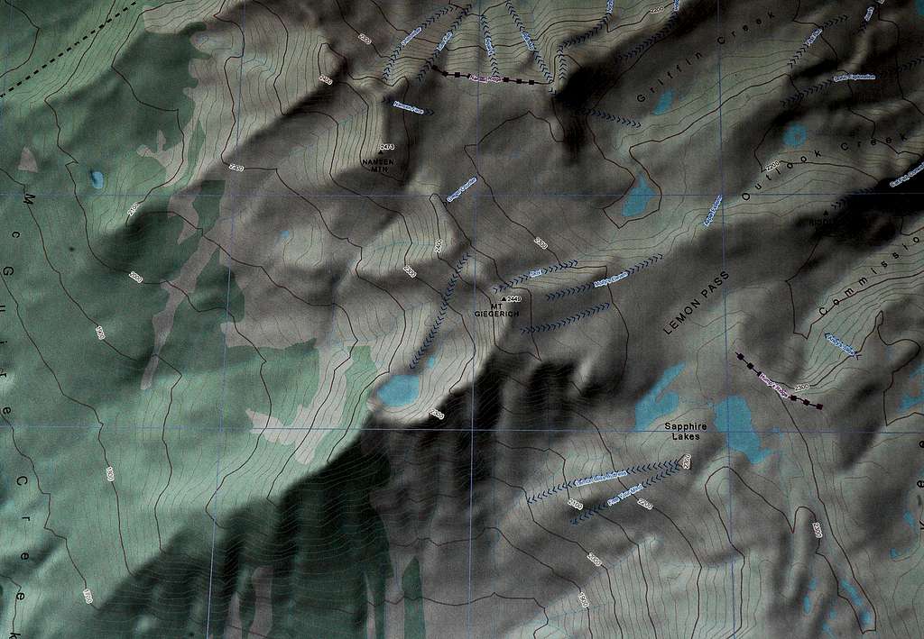
The picture below shows the ski runs on, and around the area of, Mount Giegerich.

Along with the incredible abundance of snow the area receives, comes the corresponding avalanche risks. Up to and including 2011, there have been 14 avalanche fatalities involving backcountry skiers in the park. Being equipped for and being knowledgeable of travel through terrain with avalanche risks is a must. Touring groups are expected to be self reliant in terms of rescue and choice of ski terrain.
Red Tape
Dogs are not allowed in Kokanee Glacier Provincial Park at any time.
There are no open fires allowed in the park.
Maximum stays allowed in the park: 7 consecutive days; 14 days per year total.
Alpine Club of Canada winter lottery rules and logistics
Winter guests information
When to Climb
The ideal times for the Mount Giegerich scramble are mid-July to the end of September, depending on the specific conditions in any given year. The trail to Lemon Pass can potentially be covered with snow into early August and patches of snow can exist year round. As mentioned earlier, Giegerich is an objective for backcountry skiers, making it possible in all four seasons. However, access into the park is limited at certain times of the year. Winter access into the park and the cabin are by helicopter only. The road to Gibson Lake is not plowed in the winter months and the trail crosses several avalanche zones.
When snow exists, traversing across the slope above Kokanee Lake can be very difficult and treacherous. The slope is susceptible to slides. And the lingering snow in early summer can make hiking poles and even an ice axe needed items. In early summer, wait until afternoon to traverse across the slope so that you are able to kick steps into the softened snow. You would not want to try to make the traverse across this slope by attempting to kick steps into frozen snow.
Outside of the months where it is possible to hike into Kaslo Lake, Giegerich should only be attempted by those winter guests who are staying at the Kokanee Glacier Cabin. Furthermore, winter touring groups are expected to be self reliant in terms of avalanche rescue and choice of ski terrain.
Camping & Lodging
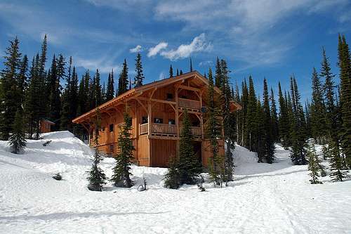
Most people staying in the core of Kokanee Glacier Provincial Park stay at the Kokanee Glacier Cabin at the north end of Kaslo Lake. It is an ideal location for hiking, scrambling, and backcountry skiing. Bookings during the summer can be made through the Alpine Club of Canada. Walk in guests can register at the cabin itself, but are not guaranteed spots will be available.
There is also camping in the core at the park at the south end of Kaslo Lake (10 sites) or down at Tanal Lake. Camping is no longer allowed at Sapphire Lakes. Also, the Slocan Chief Cabin has been converted into an interpretive centre on the history of the park and is no longer an option for shelter for the night.
As of 2011, the summer prices for staying in the park are:
Cabin (per night):
$25/person (children 12 and under free)
Camping (per night):
$10/adult
$5/adolescent (13 to 18 years old)
Children 12 and under free
In the winter season, availability at the Kokanee Glacier Cabin is through a lottery system. Those who obtain a spot for their group in the lottery are flown in and dropped off at the cabin for a period of one week. There are no accommodations for walk-ins during the winter months. Links for all the information on the lottery system and winter guests can be found on the Alpine Club of Canada’s page for the cabin:
http://www.alpineclubofcanada.ca/facility/kglacier.html
For the 2011/2012 season, the links are:
Lottery information
Winter guests information

Mountain Conditions
Nelson Weather Forecast
Updated forecasts are available at the Kokanee Glacier Cabin.
Be prepared for any conditions year round. Snow is possible in any month and lightning storms are frequent in the summer.
Trail Conditions
Canadian Avalanche Centre bulletins for the South Columbia Mountains
External Links
Kokanee Glacier Provincial Park
Alpine Club of Canada's page for the Kokanee Glacier Cabin
Discover Nelson Website


