
-
 38447 Hits
-
 88.53% Score
-
 27 Votes
|
|
Mountain/Rock |
|---|---|
|
|
39.17880°N / 106.5059°W |
|
|
Hiking, Mountaineering, Scrambling, Skiing |
|
|
Spring, Summer, Fall, Winter |
|
|
13845 ft / 4220 m |
|
|
Mount Oklahoma Overview
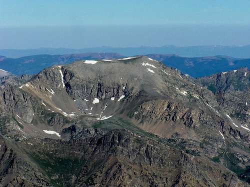
Residing in a sea of 14,000 ft. peaks, Mt. Oklahoma (13,845 ft.) is the real deal. Only 1.8 miles west of Mt. Massive, Mt. Oklahoma rests quietly within the backbone of the Colorado Continental Divide, the Sawatch Range. This complex range stretches nearly 100 miles north and south, starting at Tennessee Pass and ending at the Marshall Pass area. The Sawatch is home to 15 fourteeners and 14 centennial thirteeners; no other Colorado mountain range contains as many Centennials. When hiking this range, there are a few things you can count on, long approaches, plenty of vertical, and endless Class 2 hiking.
Mt. Oklahoma is another big and bulky Sawatch mountain, similar in configuration to Colorado's highest two mountains, Mt. Elbert and Mt Massive. Staying with the typical Sawatch mountaineering theme, Mt Oklahoma has steep surrounding slopes and gentle, broad ridges leading to its large summit plateau. In contrast to its popular neighboring fourteeners, Mt. Oklahoma does not have a trail all the way to its summit. You should find solitude, a moderate challenge in route finding, and a better summit view than most fourteeners in the area. The easiest route for Oklahoma is the Class 2 southeast slopes route however there is a more obscure route that ascends the north ridge. The standard route starts at the Halfmoon Creek Trailhead (10,240 ft.), and covers 8 miles round trip and around 3,700 feet vertical gain.
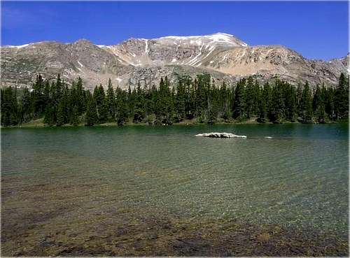 Mount Oklahoma Mount Oklahoma | 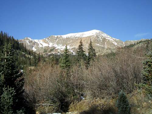 Snow-capped Mount Oklahoma from the Halfmoon Lake Trail Snow-capped Mount Oklahoma from the Halfmoon Lake Trail |
Getting There - North Halfmoon Creek TH
Starting in Leadville Colorado, continue on U.S 24 about 3.5 miles from the center of town. You will see a turn-off on your right (west) for Colorado 300 right outside of the city limits. Turn right and go .07 miles on Colorado 300 (paved). Turn left on Lake County 11 (dirt). Go 1.8 miles and turn right on another dirt road with an obvious sign for Halfmoon Campground. Go 5.6 miles on FS 110 to the Halfmoon Campground and continue on passed the Elbert Creek Campground at 6.7 miles. At 7 miles you will reach the well-marked Mt. Massive Trailhead, which is also the Colorado Trail. Continue another 2 miles until the road abruptly gets rougher, there is a turn-off to the left. Four-wheel drive vehicles can go another .5 mile on FS 110 to the actual Halfmoon Creek Trailhead. This is also the trailhead for a hike to Halfmoon Lake or an alternate route up Mt. Massive's east slopes.
 Mount Oklahoma from high in North Halfmoon Creek Basin Mount Oklahoma from high in North Halfmoon Creek Basin | 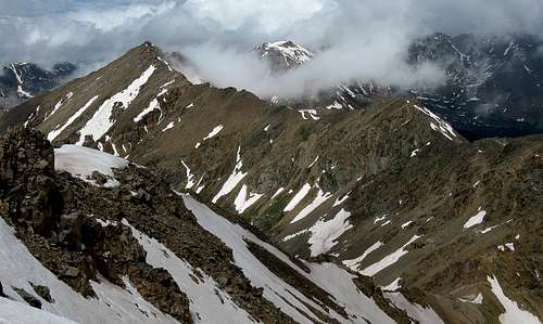 Looking across most of the traverse from Mt Oklahoma to UN 13736 Looking across most of the traverse from Mt Oklahoma to UN 13736 |
Standard Route - Southeast Slopes
Approach
Start hiking on FS 110 which is a 4WD dirt road and go west about a half mile to the start of the Halfmoon Creek Trail at 10,500 feet. This half-mile portion of the hike can be easily bypassed with a high-clearance vehicle. Begin hiking northwest on a well-worn single-track trail which gradually ascends with Halfmoon Creek up into the beautiful basin between Point 13,045 and Mt Massive. At 11,400 feet, you will reach a large meadow with good views of Deer Mountain to the west. From the meadow, leave the trail and head northwest up through trees for about a half mile to another nice meadow at 11,770 feet where you will break out of the trees and see the east ridge of Mount Oklahoma above you. Continue due west up the bowl just south of Oklahoma. In summer this bowl is lots and lots of talus but in spring it makes a nice snow ascent. Aim for the gentle slope where there is the break in the cliffs to your right. At 12,700 feet you will reach the base of the slope leading up to the east ridge.
 Massive from North Halfmoon Creek Trail Massive from North Halfmoon Creek Trail |  North Halfmoon Creek TH North Halfmoon Creek TH |
Route
Begin ascending to the north up the talus on the nice consistent slope for 500 feet to the crest of the east ridge at 13,200 feet. Continue the final 650 feet to the summit by heading northwest up the gentle upper slopes of the mountain. When this is covered in nice firm snow the climb is very enjoyable. Descend the way you came. You can also ascend class 4 rock and some steep snow just to the right of the standard ascent slope for some added fun (see red line in the photo below).
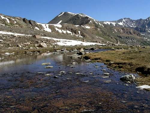
 Mount Oklahoma from Mount Elbert. Notice the break in the cliffs right in the middle of the photo...this is the route Mount Oklahoma from Mount Elbert. Notice the break in the cliffs right in the middle of the photo...this is the route | 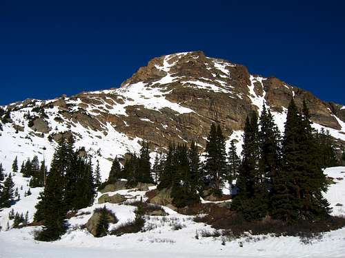 The nice meadow at 11,700 feet near treeline with Mount Oklahoma The nice meadow at 11,700 feet near treeline with Mount Oklahoma |  Sunrise from the summit of Mount Oklahoma Sunrise from the summit of Mount Oklahoma |
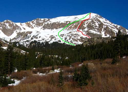 GREEN: Standard Southeast Slopes - Class 2 RED: Snow couloir/Scramble Variation I Took - Class 4
Camping/Red Tape
Plenty of camping can be found in the area. Halfmoon Campground and Elbert Creek Campground are within a couple of miles of the trailhead on the Halfmoon Creek Road. Here is an excellent link for Colorado Camping Reservations. An additional reservation fee of $8.65 is charged for this service. Snow closures vary on FS 110. Early winter snow closure can be as soon as Halfmoon Campground. Complete melt-out is by mid or late June. For a check of road conditions in and around Leadville by calling (719) 486-1410 or (719) 486 1249.
Some wilderness areas in Colorado now, or will soon be implementing a free required permit that parties must obtain at trailheads. This isn't to start requiring fees to enter but rather get a better idea on use of the wilderness areas. Some of these include the Holy Cross Wilderness, Maroon/Snowmass Wilderness among others. Specific information about this can be viewed here.
 Mount Massive seen from Mount Oklahoma
Map
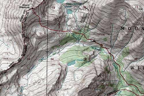 Map of the standard route on Mount Oklahoma
External Links
North Halfmoon Creek TH Conditions
Mount Oklahoma on Lists of John
Great Standard Route Trip Report