-
 96711 Hits
-
 82.48% Score
-
 15 Votes
|
|
Mountain/Rock |
|---|---|
|
|
35.62562°N / 82.28876°W |
|
|
Buncombe |
|
|
Hiking |
|
|
Spring, Summer, Fall, Winter |
|
|
3760 ft / 1146 m |
|
|
Overview
“Lookout” is deservedly the most beloved and popular hike in the vicinity of Black Mountain and Montreat, North Carolina. A little burst of energy on a beautifully designed trail takes you to a rocky viewpoint overlooking Montreat and its surrounding wilderness.
Lookout has two summits. Big Lookout, the higher one at 3760 feet, has a wooded top and doesn’t get many visitors. When people say “I’m climbing Lookout,” they generally mean Little Lookout, the rocky southwest summit of the overall mountain. Montreat expert Perrin Wright has surveyed Little Lookout’s elevation at 3621 feet.
Getting There

Trailhead marker
The mountain is located in Montreat, North Carolina. Take the only road into Montreat (NC 9). One mile beyond the Montreat Gate, turn right onto Lookout Road. Follow this about half a mile to a well-marked trailhead with parking on the right.
Routes
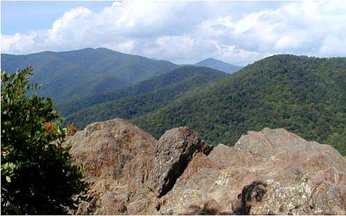
North from the top of Little Lookout. Graybeard at left center; Pinnacle (5665') in distance. Photo used by permission of The Inn on Mill Creek Innblog.

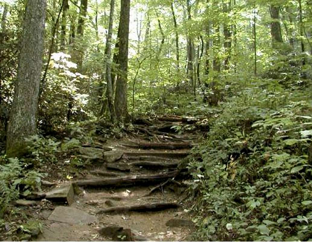
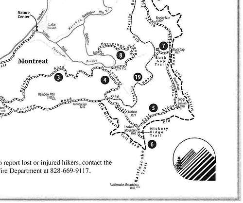
Lookout Trail (Lookout Trace): The main trail to Little Lookout, blazed with yellow diamonds, is just 0.57 miles long. Maintaining a pretty steady 23% grade, it climbs 700 vertical feet in that distance. After first ascending along a brook for a couple of hundred yards, the trail tunnels through a pretty stretch overhung by rhododendrons. Exactly halfway up in terms of vertical rise, it crosses the Old Trestle Road, once the railbed of a narrow-gauge logging and tourist railroad to Mt. Mitchell. Above here, the trail climbs an increasingly steep and exciting ridge to the viewpoint. There is a little bare rock to scramble over toward the end.
A more primitive trail continues from the far side of the Little Lookout summit, climbing the additional 140 vertical feet to Big Lookout in about 250 yards. The trail over to Big Lookout is the beginning of Montreat’s East Ridge Trail that eventually continues all the way to Long Gap.
South Side: The Old Mitchell Toll Road is a gated track that was once the route for Model T’s to chug their way to Camp Alice below Mt. Mitchell. It circles behind (south of) Lookout. You get on the Toll Road by making a 100-yard jog to the right on the Trestle Road when you encounter it halfway up the regular trail. Turning left onto the Toll Road, follow this gently-graded route a little more than half a mile. There is a well signed intersection with the Hickory Ridge Trail on the left, which takes you 300 yards to the top of Big Lookout.
People staying at Ridgecrest can climb Lookout via the Rattlesnake Mountain trail behind their own property, continuing to the Old Mitchell Toll Road and the Hickory Ridge Trail. Details are in the description of Rattlesnake Mountain.
Loop: About as nice a short hike as you will devise around Montreat is to make a loop taking in both Lookout summits and Rattlesnake Mountain. Start by climging Little Lookout by the Lookout Trail, continuing across to Big Lookout. At the very top of Big Lookout, take a right onto the marked Hickory Ridge Trail and descend 5 minutes to the Old Mitchell Toll Road. Walk 50 yards right and turn downhill again on the well signposted trail that leads on 0.3 miles to Rattlesnake Mountain. After taking in Rattlesnake, return to the Old Mitchell Toll Road and turn downhill, following it until you reach the Trestle Road; turn right and shortly rejoin the Lookout Trail. All this adds up to about 2½ miles with elevation gains of 1100 feet in total.
Red Tape
The Montreat valley is privately owned by the Mountain Retreat Association, affiliated with the Presbyterian Church. Hikers are welcome. You can’t camp anywhere near Lookout, and you can’t mountain bike on the Lookout Trail.
Mountain Bikes are allowed on the Rainbow Road and the Old Mitchell Toll Road, but NOT the Trestle Road or any of the other trails. In addition, the Old Mitchell Toll Road is closed to mountain biking in bear hunting season. Montreat has been closed to mountain biking in the past, and it will be again if this restriction is not respected.
Local Lodging
Assembly Inn, Montreat
B&B Black Mountain
B&B near Ridgecrest
Camping--Montreat
Camping--Old Fort
Recommended vacation rental in next valley
Trail running over Lookout and the Seven Sisters:
Link 1
Link 2
Link 3
A handstand at the top of Lookout (along with more trail running)
![]()
Links and Sources
Perrin Wright, Geographic Place Names In and Around Montreat, N.C. (2003).Trail running over Lookout and the Seven Sisters:
Link 1
Link 2
Link 3
A handstand at the top of Lookout (along with more trail running)
Reward
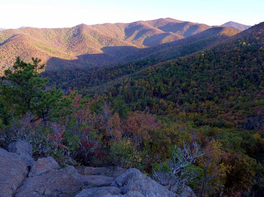
Anytime of the day or year, Lookout rewards a short effort with the finest of views. Here's the outlook across the Montreat wilderness at dawn in October: