
|
|
Route |
|---|---|
|
|
40.24010°N / 105.6592°W |
|
|
One to two days |
|
|
Class 4 |
|
|
Pilot Mountain
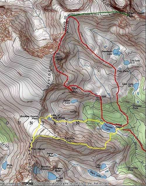
RT -17 miles and 5,000-ft
First, car camping is not allowed at the Wild Basin TH, and the parking area is patrolled during the night. Remember, there is a Ranger Station just down the road-see “Camping”.
For Pilot Mountain I will describe the route from the summit of Mount Alice. Climbing Alice first makes sense when climbing Pilot Mountain. However, if your goal is Pilot, then an approach from Thunder Lake would work. Also, Pilot is one of those peaks that you descend to get to its summit, like Lone Eagle Peak.
First read an excellent Hourglass Ridge Route description for Mount Alice by SP member Smudge.
From the 13,310-ft summit of Mount Alice, descend south about 250 vertical feet before leaving the south ridge. From here, locate Mount Alice’s steep grassy southeast slopes and begin your descent. Locate a climbers trail that helps expedite the descent to Pilot Mountain. Once on the trail, descend about a 1000-ft and look sharp to the right and locate the obvious summit pinnacle of Pilot Mountain. Depending on how you feel at the moment, the view of Pilot from here can be discouraging or inspiring.
Leave the trail and traverse south, down into a steep, grassy, ledge-ridden gully. Cross below a snowfield at the base of some cliffs and ascend back up to the gentle, grassy slope just north of Pilot. Using the slope to get to the ridge crest of Pilot won’t go because of a surprise cliff band to the south. The TOPO does not show this cliff band. Hike west to the top of the slope to the base of more cliffs. From here, you can peer down into the Falcon Lake area. Locate a slight weakness in the cliff band and descend a steep, narrow, class 3 dihedral to the ridge that escorts you to Pilots summit via the knife edge. This grassy ridge quickly turns into a knife-edge towards the summit.
Traverse out onto the ridge as it quickly turns into a knife-edge. Traverse the exposed knife-edge, using bomber holds and cracks. Continue traversing sometimes reaching the ridge crest until you get to an obvious notch in the ridge, just below Pilot’s summit pinnacle. From here you can peer 800-ft down to the south to Falcon Lake. Locate some class 4 rock in the notch that ascends about 15 feet out of the notch onto more near vertical slabs of granite. From the slabs traverse another 6 ft onto the incredibly exposed north face of Pilot Mountain. From here, climb more exposed class 3 rock to the tiny summit. There is enough room for 2 people on the summit.
While you are on the summit, the slope 450-ft below to the north is a lot steeper than the TOPO indicates. Using this slope to descend back down into the Fan Falls area will save you from having to climb back up to the beginning of the descent to the summit. Warning…this rocky slope cliffs-out at the bottom, however with good route finding you can descend through the cliffs.
NOTE: From the beautiful Fan Falls you can drop down into the Thunder Lake area. It seems cliffed-out but it goes with careful route finding. There is a small pond just north of Fan Falls. Hike to the south side of the lake and cross Fan Falls Creek and ascend a about 20 vertical feet up a treed knoll. Drop down the other side of the knoll and locate a steep dirt gully. This class 3 dirt gully descends steeply through the trees about 100 yards east of fan falls. From here, follow Fan Falls Creek where it meets with Falcon Lake Creek and follow it back to the Thunder Lake Trail, which circles Thunder Lake.