
-
 10028 Hits
-
 77.48% Score
-
 8 Votes
|
|
Mountain/Rock |
|---|---|
|
|
39.77350°N / 2.78330°E |
|
|
Download GPX » View Route on Map |
|
|
Hiking |
|
|
Spring, Summer, Fall, Winter |
|
|
3556 ft / 1084 m |
|
|
Overview
 Puig de sa Rateta summit above Cùber Reservoir Puig de sa Rateta summit above Cùber Reservoir |
Mallorca, the largest of the Islas Baleares is best known for its coasts and beaches. Howeverm, with Serra de Tramuntana it has its own mountain range, which follows the whole western coastline from the north-east to the south-west. The range is made up from rather brittle limestone, which forms large barren karst areas. Though vegetation takes hold in nooks and crevices trees only grow in the valley so that the range looks much mor impressive than it actually is. Its highest mountain, Puig Major is less than 1500m high and any summit higher than 1000m is considered a big one.
 |  |  |
Thus it is not surprising that a triplet of three mountains, Puig de Sa Rateta, Puig de Na Franquesa and Puig d l'Ofre range among the most popular summits, especiallly since they can be climbed at one go in a large loop trail. This loop is considered one of the must-do activities for hikers on Mallorca. All three are higher than 1000m and thus offer excellent views across Serra de Tramuntana and the rest of the island. The first (north-easternmost) summit of these is Puig de Sa Rateta.
 |  |  |
Together with Morro de Cùber it towers above Embalse de Cùber, a drinkwater reservoir in the midst of Serra de Tramuntana. While steep faces bound the summit on three sides (W/N/E) the southern side is accessible via a paved camino, which heads up from Coll de Roca Mala towards the summit. In the summit's vicinity you find a large, sloped karst plateau on which in all times of the year you find grazing sheep and goats.
 |  |  |
The mountain itself is twin peaked. Both summits lie on the north-west ridge and are separated by some 200m. From the higher north summit you have a stunning view towards the Cùber Rreservoir with Puig Major and Puig de Massanella towering above on both sides. To the south you can see Serra de Afabia and Serra de Boixos (both also part of Tramuntana) and in the east the bulk of the island shimmers in the distance behind a handful of table-top mountains.
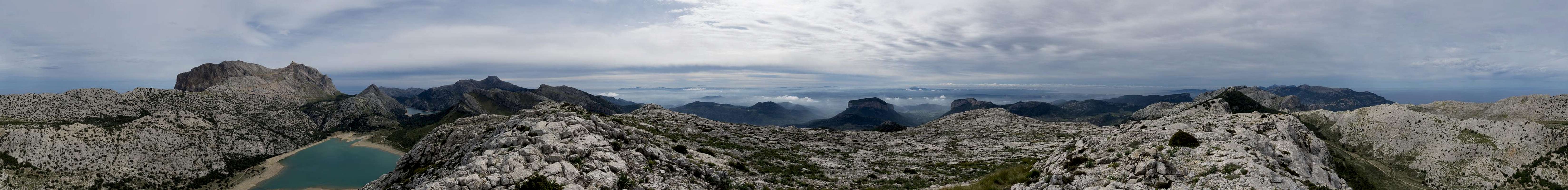
360° Summit Panorama
  |
Getting There
 Puig de Sa Rateta seen from Coll des Gats
A typical tourist location, the island Mallorca can be best reached by plane. There are flights from virtually every European international airport to Palma de Mallorca. From the island capital the following itinerary leads to the most common trailhead at Font des Noguer:
- Take motorway Ma-13 from Palma north-east to Inca.
- Switch to Ma-2130, direction Lluc Monastery
- At the intersection between Ma-2130 and Ma-10 to Polenca switch onto Ma-10 in direction of Sòller.
- Pass Embalsement de Gorg Blau. There are two parking lots, one close to the source Font des Noguer, one a little later near Embalsement de Cuber. Both are connected by a short trail.
Route
 Puig de Sa Rateta north summit seen in front of Puig Major
Start at Embalse de Cùber and follow its eastern side until you reach the dam. Cross it to the far side, where a narrow path heads into the canyon of Torrent d'Almedrà. Follow the canyon, twice switching sides and crossing through the saddle Pas de sa Foradada. About the double distance from the pass a path turns off steeply to the right, turning into a paved mulaateria later on. It negotiates the south face of Puig de Sa Rateta, quickly gaining height. Finally you reach the karst plain around the summit, where orientation gets a bit more difficult, especially in foggy conditions. In clear weather make the beeline to the summit.
Descend along the ridge towards the south-west, climbing a side summit, then quickly losing height by climbing down to Coll des Gats. From here, still following the ridgeline head up to Puig de Na Franquesa. Halfway up the mountain, the path turns away from the ridge and climbs a broad couloir to the vicinity of the summit. Again, descend (very steeply) towards the next saddle, Coll des Cards. Here a path turns off to the north-west, heading to Coll d l'Ofre. Instead stay on the original path which now negotiates the overgrown north side of Puig d l'Ofre. Some 40m beneath the summit a very steep path (sections UIAA I) turns off towards the summit.
Return to this intersection then follow the original path further towards the south-west. In Coll d'en Poma turn north around Puig de l'Ofre until you reach Coll d l'Ofre. From here a straight path / road heads down to Embalse de Cùber, where you can reach the starting point along either side.
Red Tape
There is no red tape here. However, most of Mallorca is privatelly owned and hiking these trails is rather condoned with in many places. There are some gates on the way back to the reservoir - please keep them shut. The Cùber Reservoir itself stores drinking water so please keep it clean. Also, swimming is not allowed.When to Climb
You can climb Puig de Sa Rateta all year round, however September through May is the best time. Avoid the hot summer months. In Winter snow may cover Serra de Tramuntana. I wouldn't think of skiing here but snowshoeing definitely can be an option.Accommodation
 Northern Serra de Tramuntana seen from the summit
Generallly, there are lot of accommodation options on Mallorca, which you can find on the usual portals. Prices, however, are quite high.
The trekking trail GR221 runs along the area. There are several self-service huts along its way, the closest ones Refugi dels Cornadors and Refugi Cùber.
Weather Conditions
 Puig de Sa Rateta seen during the ascent of Puig de Massanella
The right clothing provided, the mountain can be accessed in any weather condition.
Maps & Books
There are many publications about hiking on Mallorca. I include the ones which I have used myself as well as recommendations by other SPers. The book by Rolf Götz, which is available in four languages has a good choice of routes, two thirds of them in Serra de Tramuntana. Two routes are dedicated to Massanella.In particular I want to recommend the book by Marc Schichter & Kirsten Elsner, even though it is only available in German. It comes with an excellent map of Serra de Tramuntana (probably the best available) and lots of routes which can be connected at will.
Maps
- Mallorca
4 map box set
Kompass Verlag
1:35000
ISBN: 978-3-99044-062-9
- Walk Mallorca
Discovery Walking Guides
1:40000
ISBN: 978-3-99044-062-9
Books
- Mallorca
Rolf Götz
Rother Verlag
ISBN: 978-3-7633-4805-3 (English)
ISBN: 978-3-7633-4122-1 (German)
ISBN: 978-3-7633-4923-4 (French)
ISBN: 978-3-7633-4701-8 (Spanish)
- Wandern auf Mallorca
Marc Schichter & Kirsten Elsner
Reise Know-How
ISBN: 978-3-89662-289-1
- Walking in Mallorca: Classic Mountain Walks in Mallorca
June Parker
Cicerone Press
ISBN: 978-1852844882